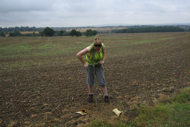
Systematic geochemical sampling and analysis of rural stream sediment, stream water and soil samples was carried out across the UK by the G-BASE and TellusNI projects, resulting in a number of regional geochemical datasets and outputs.
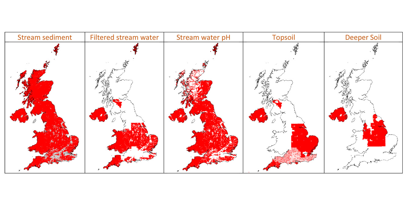

Spatial extent of geochemical data coverage.
General enquiries about the G-BASE project, data sales and products can be submitted through BGS Enquiries.
Visit the geochemistry section of the BGS Onshore GeoIndex to search for G-BASE sample locations and data availability across the UK. This on-line GIS displays sample sites for the different media collected (soil, sediment, water and pan concentrates) on a topographic backdrop. Individual sites can be selected and detailed information about site identifiers and the analytes determined can be displayed.
Attached to the GeoIndex is a comprehensive set of information pages about BGS UK geochemistry data holdings (soil, sediment, water, panned concentrates and rock).
Main outputs of G-BASE
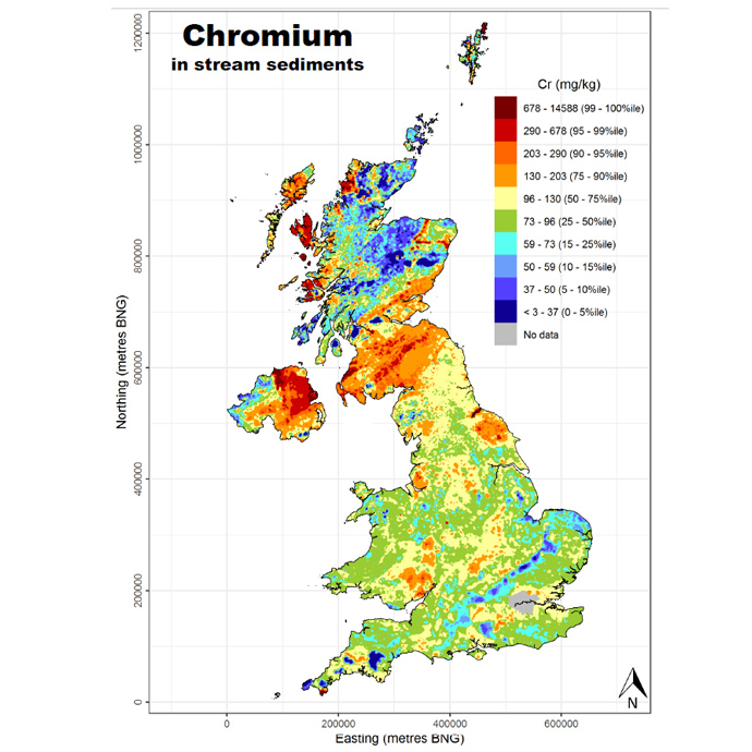
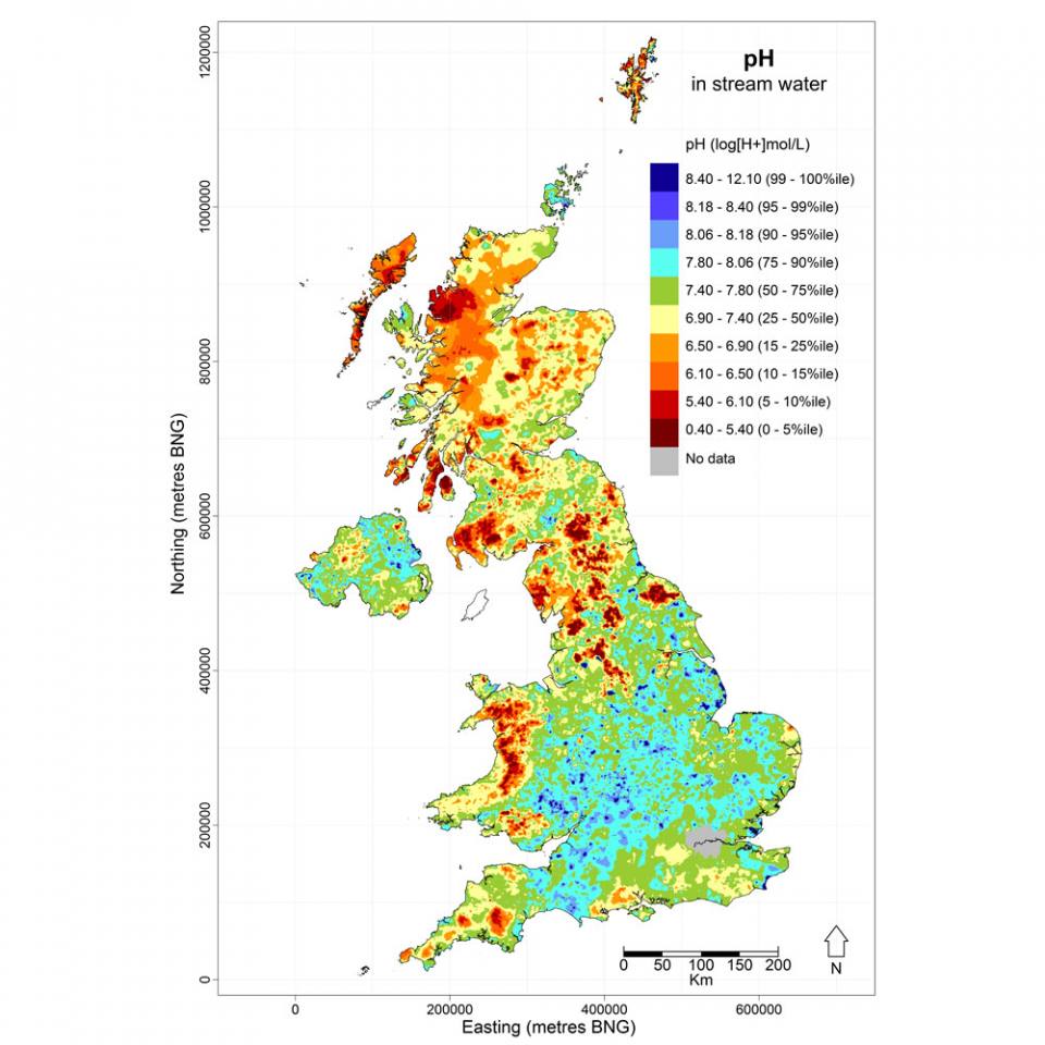
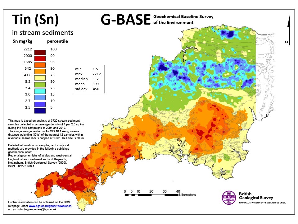
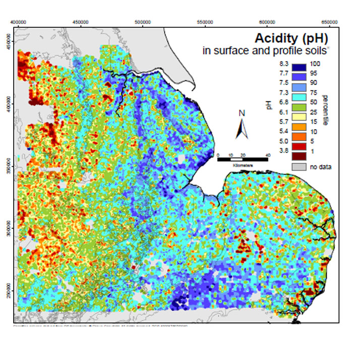
Geochemical maps are the principle means of presenting the G-BASE regional (rural) stream sediment, stream water and soil data. These comprise interpolated images of the point geochemical data that are published at various scales.
In the past, geochemical data was printed as a series of hardcopy geochemical atlases for certain regions of Great Britain in the Regional geochemical atlas series. More recently, geochemical atlases and interpolated data grids have been published in digital format as follows.
G-BASE and TellusNI UK geochemical data
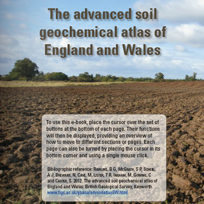
- The advanced soil geochemical atlas of England and Wales
- Interpolated grids of the elements in the advanced atlas
Maps from the advanced atlas can be viewed in the UK Soil Observatory (UKSO) viewer.
G-BASE soil data is available under licence from the BGS. Please contact BGS Enquiries.
G-BASE stream water geochemistry data is available under license from the BGS. Please contact BGS Enquiries.
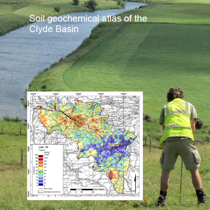
G-BASE regional products
Soil maps from south-west England can also be viewed in the UK Soil Observatory (UKSO) viewer.
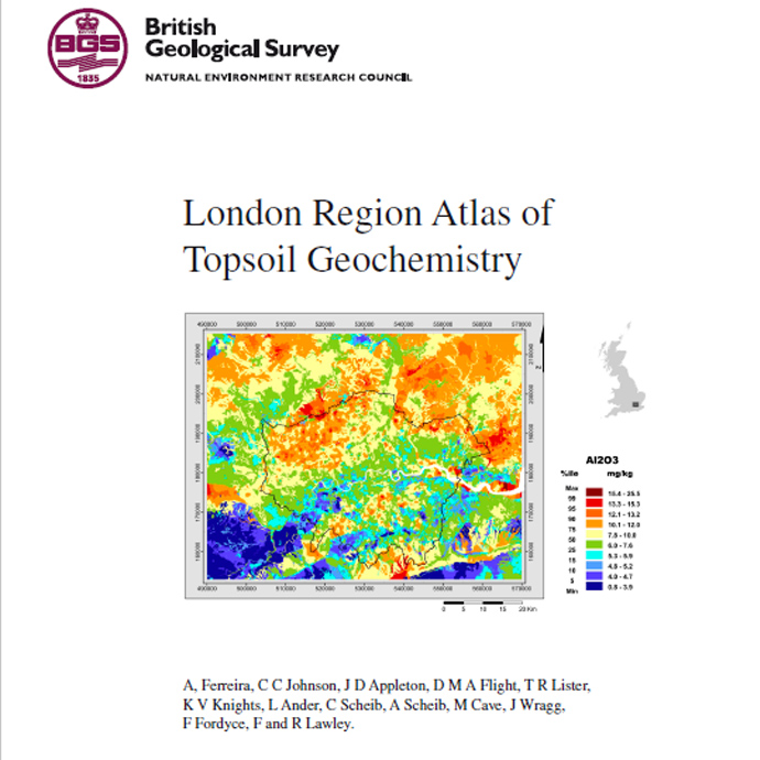
- London Region Atlas of Topsoil Geochemistry (overview)
- London Region Atlas of Topsoil Geochemistry (pdf)
- For London urban publications see London Earth
Publications
Appleton, J D, and Cave, M R. 2018. Variation in soil chemistry related to different classes and eras of urbanisation in the London area. Applied Geochemistry, Vol. 90, 13–24.
Appleton, J D, Johnson, C C, Ander, E L, and Flight, D M A. 2013. Geogenic signatures detectable in topsoils of urban and rural domains in the London region, UK, using parent material classified data. Applied Geochemistry, Vol. 39, 169–180.
Ferreira, A, Johnson, C C, Appleton, J D, Flight, D, Lister, T R, Knights, K V, Ander, L, Scheib, C, Scheib, A, Cave, M, Wragg, J, Fordyce, F, and Lawley, R. 2017. [Online] London region atlas of topsoil geochemistry. Earthwise, British Geological Survey.
Publications
Appleton, J D, Cave, M R, and Wragg, J. 2012. Modelling lead bioaccessibility in urban topsoils based on data from Glasgow, London, Northampton and Swansea, UK. Environmental Pollution, Vol. 171, 265–272.
Breward, N. 2007. Arsenic and presumed resistate trace element geochemistry of the Lincolnshire (UK) sedimentary ironstones, revealed by a regional geochemical survey using soil, water and stream sediment sampling. Applied Gechemistry, Vol. 22(9), 1970–1993.
Breward, N, Kemp, S J, Ambrose, K, Powell, J H, Morigi, A, and Wagner, D. 2015. Anomalous enrichment of molybdenum and associated metals in Lower Jurassic (Lias Group) black shales of central England, as revealed by systematic geochemical surveys. Proceedings of the Geologists’ Association, Vol. 126(3), 346–366.
Cave, M R, Wragg, J, and Lister, R. The effect of lead in soil on crime deprivation in Derby, Leicester and Nottingham Applied Geochemistry, Vol. 88(B), 198–212.
Freestone, S E, O’Donnell, K E, and Brown, S E. 2004. Geochemical baseline data for the urban area of Kingston-upon-Hull. British Geological Survey Internal Report IR/02/080. (Nottingham, UK: British Geological Survey.) (Unpublished.)
Freestone, S E, O’Donnell, K E, and Brown, S E. 2004. Geochemical baseline data for the urban area of Mansfield. British Geological Survey Internal Report IR/02/082. (Nottingham, UK: British Geological Survey.) (Unpublished.)
Freestone, S E, O’Donnell, K E, and Brown, S E. 2004. Geochemical baseline data for the urban area of Sheffield. British Geological Survey Internal Report IR/02/084. (Nottingham, UK: British Geological Survey.) (Unpublished.)
O’Donnell, K E. 2005. Geochemical baseline data for the urban area of Lincoln. British Geological Survey Internal Report IR/02/081. (Nottingham, UK: British Geological Survey.) (Unpublished.)
O’Donnell, K E. 2005. Geochemical baseline data for the urban area of Scunthorpe. British Geological Survey Internal Report IR/02/083. (Nottingham, UK: British Geological Survey.) (Unpublished.)
O’Donnell, K E. 2002. Geochemical baseline data for the urban area of Doncaster. British Geological Survey Internal Report IR/02/079. (Nottingham, UK: British Geological Survey.) (Unpublished.)
O’Donnell, K E. 2001. Geochemical baseline data for the urban area of York. British Geological Survey Internal Report IR/02/085. (Nottingham, UK: British Geological Survey.) (Unpublished.)
Palumbo, B, Rawlins, B, Herbert, C, Kessler, H, and Klinck, B. 2004. Human health risk assessment for exposure to soil at London Road Allotments, Coventry (UK). British Geological Survey Commissioned Report CR/04/045N. (Nottingham, UK: British Geological Survey.) (Unpublished.)
Palumbo-Roe, B, Cave, M R, Klinck, B A, Wragg, J, Taylor, H, O’Donnell, K E, and Shaw, R A. 2005. Bioaccessibility of arsenic in soils developed over Jurassic ironstones in eastern England. Environmental Geochemistry and Health, Vol. 27, 121–130.
Rawlins, B, and Brown, S. 2003. Assessing geostatistical methods for presenting urban soil geochemical data from Coventry. British Geological Survey Internal Report IR/03/012. (Nottingham, UK: British Geological Survey.) (Unpublished.)
Rawlins, B G, and O’Donnell, K E. 2004. Presentation of lead and zinc data from soil geochemical surveys of the urban area of Corby and surrounding rural land. British Geological Survey Internal Report IR/04/095. (Nottingham, UK: British Geological Survey.)
Rawlins, B G, Lark, R M, O’Donnell, K E, Tye, A M, and Lister, T R. 2005. The assessment of point and diffuse metal pollution of soils from an urban geochemical survey of Sheffield, England. Soil Use and Management, Vol. 21(4), 353–362.
Rawlins, B G, Webster, R, and Lister, T R. 2003. The influence of parent material on top-soil geochemistry in eastern England. Earth Surface Processes and Landforms, Vol. 28(13), 1389–1409.
Scheib, A J. 2007. Investigation of G-BASE regional soil geochemistry over Pleistocene till deposits in East Anglia using factor analysis. British Geological Survey Internal Report IR/07/057. (Nottingham, UK: British Geological Survey.) (Unpublished.)
Scheib, A J, and Lee, J R. 2010. The application of regional-scale geochemical data in defining the extent of aeolian sediments: the Late Pleistocene loess and coversand deposits of East Anglia, UK. Quaternary Newsletter, Vol. 120, 5–14.
Scheib, A J, Lee, J R, Breward, N, and Riding, J B. 2011. Reconstructing flowpaths of the Middle Pleistocene British Ice Sheet in central-eastern England: the application of regional soil geochemical data. Proceedings of the Geologists’ Association, Vol. 122(3), 432–444.
Wragg, J, Cave, M R, and Gregory, S. 2014. The solid phase distribution and bioaccessibility of arsenic, chromium, and nickel in natural ironstone soils in the UK. Applied and Environmental Soil Science, Vol. 2014, Article ID 924891.
Publications
For additional publications see the main G-BASE page and the Regional geochemical atlas page.
You may also be interested in

Applied geochemistry
Since the 1960s, the BGS has amassed considerable geochemical data holdings and developed significant expertise in applied geochemistry.