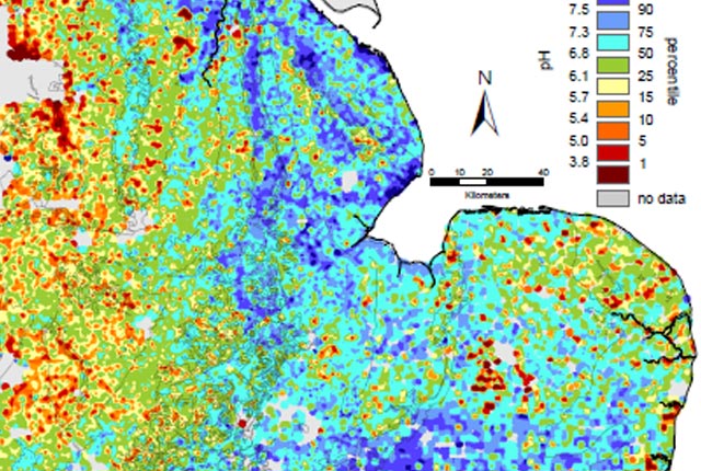
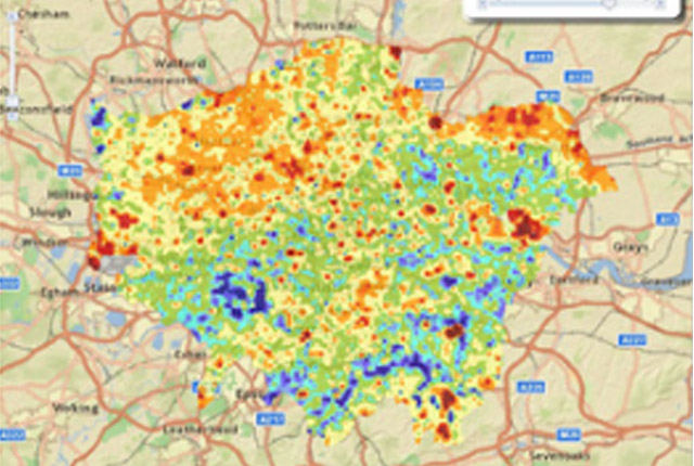
The BGS Geochemical Baseline Survey of the Environment (G-BASE) is the national strategic geochemical mapping programme in Great Britain. The project set out to establish the chemistry of the surface environment by the collection and analysis of stream sediment, stream water and soil samples.
Beginning in the late 1960s in northern Scotland and moving southwards across the country, the primary focus was mineral exploration, however, the project quickly developed to address important environmental concerns. The final G-BASE samples were collected in southern England in 2014.
The outputs from the G-BASE project provide an invaluable, systematic baseline of geochemical information for Great Britain, serving as a marker of the state of the environment against which to measure future change.
Applications of baseline geochemical data include:
- support and information for local and regulatory authorities, land use planners, developers and the general public on the state of the environment and environmental hazards
- identifying anomalous environmental conditions resulting from, for example, mineralisation and industrial pollution
- assessing the condition and health of soil, stream water and stream sediment for catchment management and agricultural and ecosystem functions
- identifying and quantifying human impact on the environment
- identifying new opportunities for mineral exploration
- improved understanding of earth system processes
We offer expertise in all aspects of baseline geochemistry, including sampling and data visualisation and interpretation, and the applications of surface geochemistry data to human and ecological health studies and mineral resource management. For more information, contact BGS Enquiries.
Based on this expertise, we have played a leading role in the development of geochemistry study methods both in the UK and internationally.
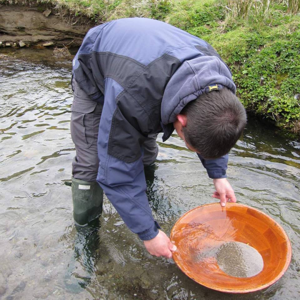
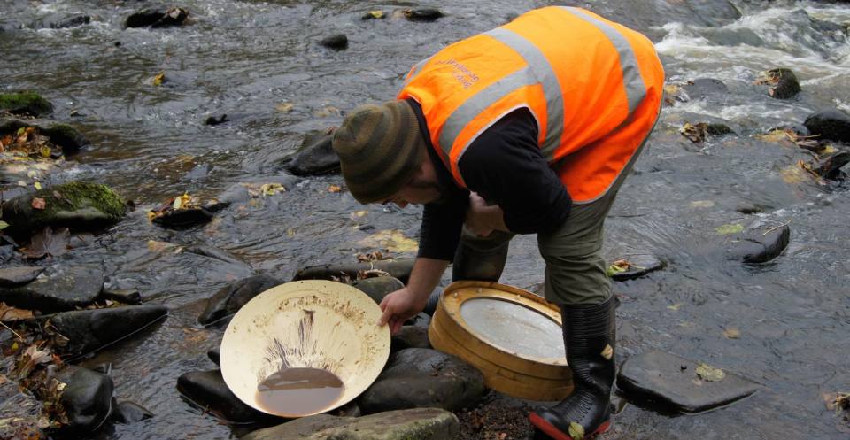
Stream sediments were the primary sample medium for G-BASE. The sediment was collected from the centre of the stream and sieved through two sieves (2 mm and 150 µm) to obtain a fine grain-size fraction of <150 µm. Excess material from the <2 mm fraction was panned to collect a heavy mineral concentrate.
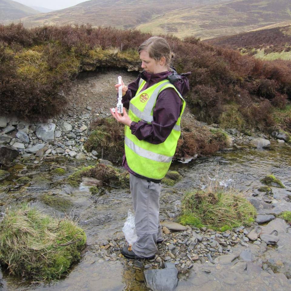
Stream water samples were collected also at each drainage site. Four different water samples were collected routinely: two filtered waters (for major and trace elements) and two unfiltered waters (for pH, conductivity and alkalinity).
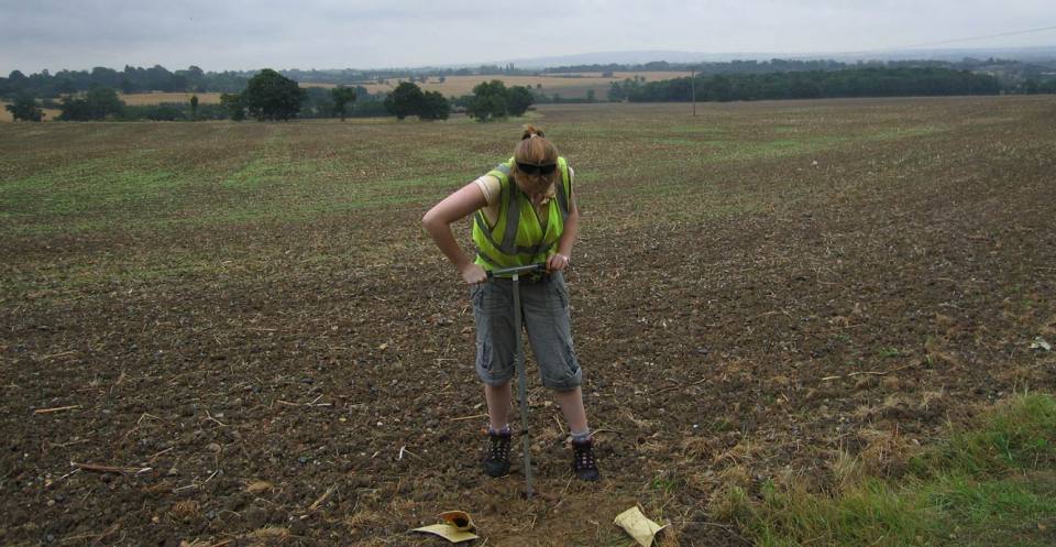
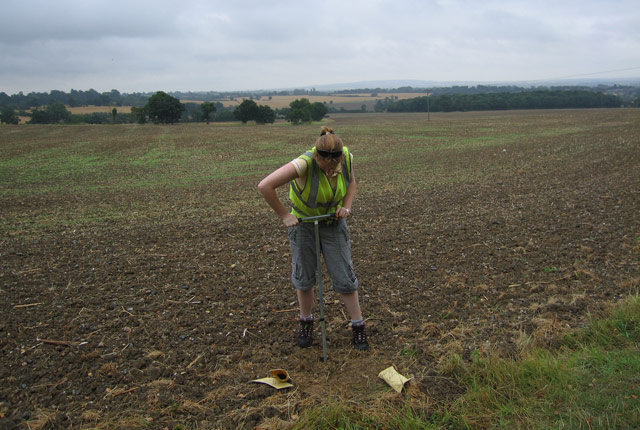
The routine collection of soil samples was introduced in 1986 in areas of poor drainage density. This coincided with the project working in agriculturally important areas of England. Understanding the chemical quality of soil is very important for environmental protection, agriculture and land-management policies.
Urban soil sampling commenced in 1991, to quantify the chemical quality of soil in city environments as an aid to sustainable planning and development.
In rural (regional) environments, stream sediment and water samples were collected at an average density of one per 1.5–2 km2, ideally from small (first or second order) streams. Soil samples were collected by hand auger, from two depths (5–20 cm topsoil and 35–50 cm deeper soil) at an average density of one every 2 km2.
In urban environments, soil samples were collected at a higher density of four samples per 1 km2.
Details of the sampling methodology can be found in the G-BASE field procedures manual.
Stream water
Stream water pH, conductivity and alkalinity were determined in the field. Water samples were returned to our laboratories and analysed by inductively coupled atomic emission and mass spectrometry (ICP-AES/MS), ion chromatography (IC)/ion selective electrode (ISE) for up to 50 chemical parameters. Waters were also analysed for non-purgeable organic carbon (NPOC) to determine dissolved organic carbon content.
Stream sediment and soil
The <150 µm fraction of the stream sediment and the <2 mm fraction of topsoil were analysed by techniques including X-ray fluorescence (XRF)/direct reading optical emission spectrometry (DR-OES) to determine the concentration of up to 53 major and trace elements. Loss on ignition (LOI) and pH were determined in topsoil samples. The deeper soil samples were stored in the G-BASE sample archive. Panned concentrate samples are also stored.
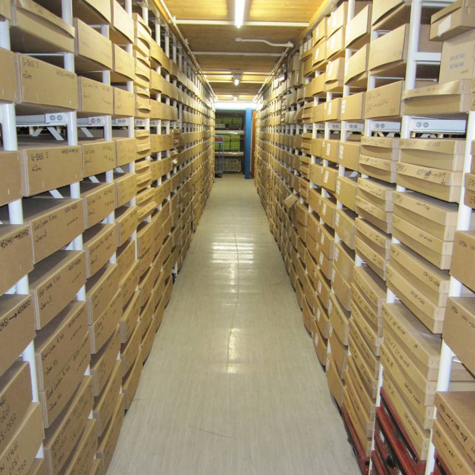
After preparation and analyses all soil, stream sediment and panned concentrate samples and excess material were stored and archived at the BGS’s National Geoscience Data Centre (NGDC). The archive holds more than 40 years’ worth of material collected across the UK from Shetland in the north to Kent in the south.
For more information on the outputs and data available from the G-BASE project see:
The G-BASE and TellusNI datasets provide information on the location of key mineral resources. In the BGS, the application of geochemistry to locate mineral deposits in Great Britain has been done principally through the now-discontinued Mineral reconnaissance programme (MRP), in which regional geochemical data generated by the G-BASE project was used to identify targets for further follow-up work.
Geochemistry, combined with geophysics, detailed geological mapping and drilling, has successfully identified new mineral deposits in many areas. Notable successes, which have attracted significant commercial investment, include discoveries of gold in the Ochil Hills in Scotland, base metals and platinum in Shetland and the world-class barytes deposit near Aberfeldy, Scotland.
In Northern Ireland, the TellusNI project generated a significant increase in mineral exploration, with mining companies that licensed the data investing more than £30 million between 2007 and 2012.
Selected publications
Allen, M A, Cave, M R, Chenery, S R N, Gowing, C J B, and Reeder, S. 2011. Sample preparation and inorganic analysis for urban geochemical survey soil and sediment samples. 28–46 in Mapping the chemical environment of urban areas. Johnson, C C, Demetriades, A, Locutura, J, and Ottesen, R T (editors). (Wiley Online Library.)
Atkinson, N R, Bailey, E H, Tye, A T, Breward, N, and Young, S D. 2011. Fractionation of lead in soil by isotopic dilution and sequential extraction. Environmental Chemistry, Vol. 8(5), 493–500.
Bearcock, J, and Wragg, J. 2015. BGS’s 250 000 shovels of mud: why each one counts and what it means. British Land Reclamation Society Journal, Vol. 5.
Di Bonito, M, Breward, N, Crout, N M J, Smith, B, and Young, S D. 2008. Overview of selected soil pore water extraction methods for the determination of potentially toxic elements in contaminated soils: operational and technical aspects. 213–249 in Environmental Geochemistry: Site Characterisation, Data Analysis and Case Histories. De Vivo, B, Belkin, H E, and Lima, A (editors). (London, UK: Elsevier.)
Fordyce, F,M, Green, P M, and Simpson, P R. 1993. Simulation of regional geochemical survey maps at variable sample density. Journal of Geochemical Exploration, Vol. 49(1–2), 161–175.
Johnson, C. 2005. 2005 G-BASE field procedures manual. British Geological Survey Internal Report IR/05/097. (Nottingham, UK: British Geological Survey.) (Unpublished.)
Johnson, C C, and Breward, N. 2004. G-BASE: Geochemical Baseline Survey of the Environment. British Geological Survey Commissioned Report CR/04/016N. (Nottingham, UK: British Geological Survey.) (Unpublished.)
Johnson, C C, Flight, D M A, Ander, E L, Lister, T R, Breward, N, Fordyce, F M, Nice, S E, and Knights, K V. 2017. The collection of drainage samples for environmental analyses from active stream channels. 45–78 in Environmental Geochemistry: Site Characterisation, Data Analysis and Case Histories. (Second Edition.) De Vivo, B, Belkin, H E, and Lima, A (editors). (Oxford, UK: Elsevier.)
Johnson, C, Ander, L, Lister, R, and Flight, D. 2008. Data conditioning of environmental geochemical data: quality control procedures used in the British Geological Survey’s regional geochemical mapping project. 93–118 in Environmental Geochemistry: Site Characterisation, Data Analysis and Case Histories. De Vivo, B, Belkin, H E, and Lima, A (editors). (London, UK: Elsevier.)
Johnson, C C, Breward, N, Ander, E L, and Ault, L. 2005. G-BASE: baseline geochemical mapping of Great Britain and Northern Ireland. Geochemistry: Exploration, Environment, Analysis, Vol. 5(4), 347–357.
Kirkwood, C, Cave, M, Beamish, D, Grebby, S, and Ferreira, A. 2016. A machine learning approach to geochemical mapping. Journal of Geochemical Exploration, Vol. 167, 49–61.
Lark, R M, Patton, M, Ander, E L, and Reay, D M. 2018. The singularity index for soil geochemical variables and a mixture model for its interpretation. Geoderma, Vol. 323, 83–106.
Lister, T R, and Johnson, C C. 2005. G-BASE data conditioning procedures for stream sediment and soil chemical analyses. British Geological Survey Internal Report IR/05/150. (Nottingham, UK: British Geological Survey.) (Unpublished.)
Plant, J A. 1973. A random numbering system for geological samples. Transactions of the Institute Mining & Metallurgy Vol. 82(Section B), 63–66.
Plant, J A. 1971. Orientation studies on stream sediment sampling for a regional geochemical survey in northern Scotland. Transactions of the Institute Mining & Metallurgy, Vol. 80(Section B), 323–346.
Rawlins, B G, Scheib, A J, Lark, R M, and Lister, T R. 2009. Sampling and analytical plus subsampling variance components for five soil indicators observed at regional scale. European Journal of Soil Science, Vol. 60(5), 740–747.
Simpson, P R. 1995. Geochemical baselines for sustainable development. The G-BASE Project – British Geological Survey. Mineralogical Society of London Bulletin. Vol. 109, 21–26.
Smyth, D. 2007. Methods used in the Tellus geochemical mapping of Northern Ireland. British Geological Survey Open Report OR/07/022. (Nottingham, UK: British Geological Survey.) (Unpublished.)
The principal hard copy product of the G-BASE project is a series of regional geochemical atlases.
Everett, P A, Lister, T R, Fordyce, F M, Ferreira, A M P J, Donald, A W, Gowing, C J B, and Lawley, R S. 2019. Stream sediment geochemical atlas of the United Kingdom. British Geological Survey Open Report OR/18/048. (Nottingham, UK: British Geological Survey.)
Ferreira, A, Johnson, C C, Appleton, J D, Flight, D, Lister, T R, Knights, K V, Ander, L, Scheib, C, Scheib, A, Cave, M, Wragg, J, Fordyce, F, and Lawley, R. 2017. [Online] London region atlas of topsoil geochemistry. Earthwise, British Geological Survey.
Flight, D M A, Christie, J L, Lister, T R, Simpson, P L, and Smith, B. 1995. Results of a pilot geochemical survey, Northern Ireland. Geological Survey of Northern Ireland Technical Report, No. GSNI/95/6. (Belfast, Northern Ireland: Geological Survey of Northern Ireland.)
Fordyce, F M, Everett, P A, Bearcock, J M, Lister, T R, Gowing, C, Watts, M, and Ellen, R. 2017. Soil geochemical atlas of the Clyde Basin. British Geological Survey Open Report OR/14/032. (Edinburgh, UK: British Geological Survey.)
Johnson, C.C. 2011. Geochemistry@BGS: a guide to geochemical data at the British Geological Survey. British Geological Survey Open Report OR/09/028. (Nottingham, UK: British Geological Survey.) (Unpublished.)
Kirkwood, C, Lister, R, Fordyce, F, and Lawley, R. 2017. User guide for the British Geological Survey stream sediment geochemistry (500 m grid) dataset. British Geological Survey Open Report OR/17/004. (Nottingham, UK: British Geological Survey.) (Unpublished.)
Rawlins, B G, McGrath, S P, Scheib, A J, Breward, N, Cave, M, Lister, T R, Ingham, M, Gowing, C, and Carter, S. 2012. The advanced soil geochemical atlas of England and Wales. (Nottingham, UK: British Geological Survey.)
Smedley, P L, Bearcock, J, M, Fordyce, F M, Everett, P A, Chenery, S, and Ellen, R. 2017 Stream water geochemical atlas of the Clyde Basin. British Geological Survey Open Report OR/16/015. (Nottingham, UK: British Geological Survey.)
Young, M, and Donald, A (editors). 2013. A guide to the Tellus data. (Belfast, Northern Ireland: Geological Survey of Northern Ireland.)
Buchanan, D L, and Dunton, S N (editors). Precious-metal distribution in Shetland: refinement of targets for gold exploration. (Lerwick: Shetland Islands Council.) ISBN: 0904562352. Available from BGS Library; please contact BGS Enquiries.
Dempster, M, Cooper, M, Dunlop, P, and Scheib, A. 2016. Using soil geochemistry to investigate gold and base metal distribution and dispersal in the glaciated north of Ireland. 89–99 in Unearthed: Impacts of the Tellus Surveys of the North of Ireland. Young, M E (editor). (Dublin, Ireland: Royal Irish Academy.)
Lusty, P A J, Scheib, C, Gunn, A, G, and Walker, A S D. 2012. Reconnaissance-scale prospectivity analysis for gold mineralisation in the Southern Uplands–Down–Longford Terrane, Northern Ireland. Natural Resources Research, Vol. 21, 359–382.
Plant, J A, Breward, N, Forrest, M D, and Smith, R T. 1989. The gold pathfinder elements As, Sb and Bi – their distribution and significance in the southwest Highlands of Scotland. Transactions of the Institution of Mining and Metallurgy, Vol. 98, 91–101.
Plant, J A, Breward, N, Simpson, P R, and Slater, D. 1990. Regional geochemistry and the identification of metallogenic provinces: examples for lead-zinc-barium, tin-uranium and gold deposits. Journal of Geochemical Exploration, Vol. 39(1–2), 195–224
Plant, J A, Cooper, D C, Green, P M, Reedman, A J, and Simpson, PR. 1991. Regional distribution of As, Sb and Bi in the Grampian Highlands of Scotland and English Lake District: implications for gold metallogeny. Transactions of the Institution of Mining and Metallurgy, (Section B).
Find out more about G-BASE
G-BASE: regional geochemistry
Systematic geochemical sampling and analysis of rural stream sediment, stream water and soil samples was carried out across the UK by the BGS and GSNI.
G-BASE: urban geochemistry
An integral part of the G-BASE and TellusNI survey programs was to map and establish the soil geochemical baselines of urban areas in the UK. Systematic geochemical sampling and analysis of soil samples was carried out in 25 urban centres.
G-BASE: environmental geochemistry
In addition to expertise in geochemical mapping, BGS geochemists are involved in numerous activities and research that relate to the collection of geochemical samples, the use of geochemical baseline data and the interpretation of those as part of a wide range of geoscientific and environmental studies.
You may also be interested in

Applied geochemistry
Since the 1960s, the BGS has amassed considerable geochemical data holdings and developed significant expertise in applied geochemistry.