Please note: CLiDE (2013) is a legacy product and is no longer actively supported. It is made available under the BGS Software Disclaimer and downloaded at the user’s own risk.
Environmental response to climate change is potentially complex, as surface processes are linked together to varying degrees. In response to the lack of appropriate holistic models tackling environmental change, the BGS initiated a research programme to address the dynamics of environmental sensitivity to climate change (DESC).
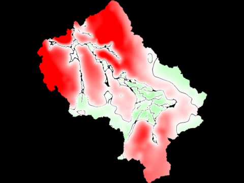


Groundwater head changes in the Eden catchment over a year. Red: increasing groundwater heads; green: reduced heads; black: no change.
CLiDE development
The DESC project seeks to explore the interactions that exist between earth systems at a range of spatiotemporal scales by coupling current landscape-evolution modelling technologies to a host of bespoke geoprocessing modules. The CAESAR-Lisflood-DESC (CLiDE) modelling platform, a quasi-3D geomorphological simulator that couples cellular automata modelling from various backgrounds, was developed to achieve this.
CLiDE is designed primarily for environmental systems research at the annual to decadal scale and is particularly focused on system interaction. A variety of climate-derived, looped feedback earth systems research can be undertaken at daily to centennial timescales.
A derived version of the well-established CAESAR model, CAESAR-Lisflood, is used as the platform kernel. The surface water partitioning and subsurface water routing components of the model have since been replaced with a distributed hydrological model. To deal with complex energy and sediment fluxes that occur during a debris flow, a modified version of the SCIDDICA model has been incorporated into the CLiDE platform.
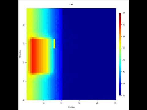
A hypothetical debris flow with a barrier positioned on slope. Colours represent elevation — blue: low; red: high.
What is CliDE being used for?
The CLiDE platform is currently being used in conjunction with Ghent University (Belgium) to assess the link between changes in land use and climate and gully development in Ethiopia and France, and in conjunction with the Indian Institute of Technology (IIT) in Kanpur to simulate erosion and sediment transport processes in the Ganges basin.
Barkwith, A, and Coulthard, T. 2014. CLiDE V1.0 user guide. British Geological Survey Open Report OR/14/011. (Nottingham, UK, British Geological Survey.)
Barkwith, A, Hurst, M D, Jackson, C R, Wang, L, Ellis, M A, and Coulthard, T J. 2015. Simulating the influences of groundwater on regional geomorphology using a distributed, dynamic, landscape evolution modelling platform. Environmental Modelling and Software, Vol. 74, 1–20.
Barkwith, A, Hurst, M, Ellis, M, and Coulthard, T. 2014. Assessing the impacts of climate, groundwater and land use on regional geomorpholog. [Poster] AGU Fall Meeting 2014, San Francisco, USA, 15–19 December 2014.
Tye, A M, Hurst, M D, Barkwith, A K A P. 2013. Nene phosphate in sediment investigation – Environment Agency Project REF: 30258. British Geological Survey Open Report OR/13/031. (Nottingham, UK, British Geological Survey.)
This data is delivered under the GNU Licence of the CAESAR-Lisflood model.
Downloads
Please enter your details to download the CLiDE executable, source code (c# .NET) and example input files.
Contact
If you want to discover more then please contact Andrew Barkwith.