In 1999, the Department of Trade and Industry (now the Department for Business, Energy & Industrial Strategy (BEIS)) began a sequence of sectoral strategic environmental assessments (SEAs) of the implications of further licencing of the UK Continental Shelf (UKCS) for oil and gas exploration and production.
The SEA process subdivided the UKCS into eight areas. Beginning in 2008, integrated offshore energy SEAs have been undertaken that cover the whole UKCS.
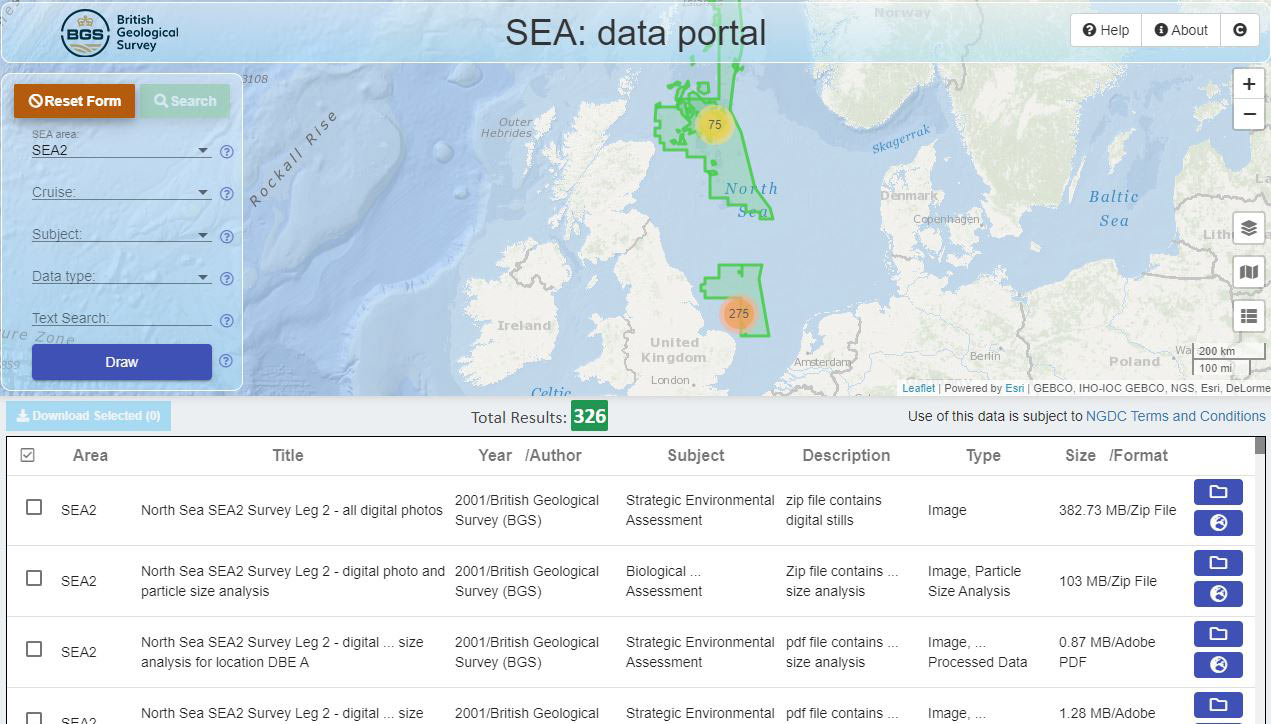

SEA data portal user interface. BGS © UKRI.
An integral part of the SEA programme has been a series of research and monitoring surveys commissioned to acquire new data about the offshore environment and used to help inform the relevant SEAs. Technical reports describing the surveys are available from the current offshore energy SEA.
To enable free and open access to data collected during the SEA surveys, BEIS commissioned us to develop and maintain this data portal with the aim of providing all reports and datasets associated with each SEA.
Find SEA data and reports
Search using forms or a map index to find data and documents by their SEA area, subject and type.
Search SEA data portal
More about SEA data
| Name | Area | Sector | Licencing / Leasing Round | Year |
|---|---|---|---|---|
| SEA 1 | The deep water area along the UK and Faroese boundary. | Oil & gas | 19th round | 2001 |
| SEA 2 | The central spine of the North Sea, which contains the majority of existing UK oil and gas fields. | Oil & gas | 20th round | 2002 |
| SEA 2 Extension | Outer Moray Firth | Oil & gas | 20th round | 2002 |
| SEA 3 | The remaining parts of the southern North Sea. | Oil & gas | 21st round | 2003 |
| R2 | Three strategic regions off the coasts of England and Wales in relation to a second round of offshore wind leasing. | Offshore wind | 2nd round | 2003 |
| SEA 4 | The offshore areas to the north and west of Shetland and Orkney. | Oil & gas | 22nd round | 2004 |
| SEA 5 | Parts of the northern and central North Sea to the east of the Scottish mainland, Orkney and Shetland. | Oil & gas | 23rd round | 2005 |
| SEA 6 | Parts of the Irish Sea. | Oil & gas | 24th round | 2006 |
| SEA 7 | The offshore areas to the west of Scotland. | Oil & gas | 25th round | 2008 |
| OESEA | UK offshore waters and territorial waters of England and Wales. | Offshore wind; oil & gas | 26th round | 2009 |
| OESEA2 | UK offshore waters and territorial waters of England and Wales. | Oil & gas; offshore wind, wave and tidal; gas and carbon dioxide storage | 27th round 28th round | 2011 2014 |
| OESEA3 | UK offshore waters and territorial waters of England and Wales | Oil & Gas, Offshore wind, wave and tidal, gas and CO2 storage | 29th round
30th round 31st round 32nd round | 2016
2017 2018 2019 |
Data types
The available data types are:
- data files (in a variety of specialist formats)
- maps
- processed data
- processed images
- raw data
- raw images
- still images (photographs)
- reports
- video
Data access and copyright
The data was produced as part of BEIS’s offshore energy strategic environmental assessment programme; © Crown Copyright, all rights reserved. The BEIS SEA must be acknowledged in any maps or publications that make use of the data. All the data files are freely available to the public.
Many files can be downloaded directly from this website. Those that are too large to download can be ordered for postal delivery from the BGS.
Intellectual property rights (IPR)
The BGS (UKRI) has been contracted by BEIS to publish SEA datasets on its behalf.
All intellectual property rights (including, without limitation, copyrights, database rights and all other rights which subsist or may at any time in the future subsist in the Dataset(s)) in the Dataset(s) (‘Intellectual Property Rights’) are owned by BEIS (formerly the Department of Trade and Industry, and the Department for Business, Enterprise and Regulatory Reform and the Department of Energy and Climate Change).
Data is made available under the Open Government Licence (OGL). Use of this data is subject to [2] NGDC terms and conditions.
About
The site is run and managed by the BGS on behalf of BEIS.
The purpose of the website is to:
- provide simple and easy access to the datasets that have been collected to date
- collect all the raw and interpreted datasets and published reports
- store the datasets in one repository for the foreseeable future
Partners
- Department for Business, Energy and Industrial Strategy: principal regulator of the offshore oil and gas industry and has overall responsibility for the SEA process.
You may also be interested in

Technologies
Applications, software and online services created by the BGS and our collaborators.