BGS·SIGMA is an integrated toolkit for digital geological data capture and mapping, which enables the assembly, capture, interrogation and visualisation of geological information as well as the delivery of digital products and services.

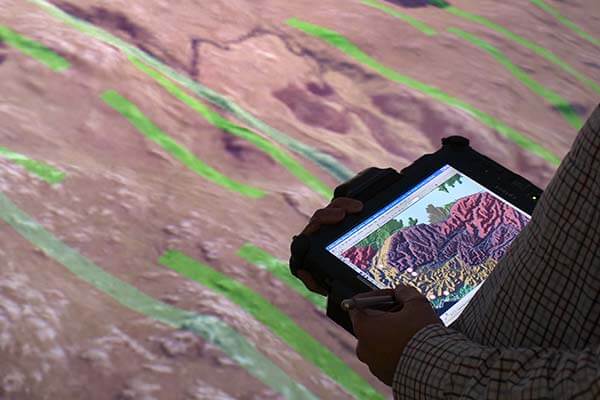
A BGS geologist using BGS·SIGMA out in the field. BGS © UKRI.
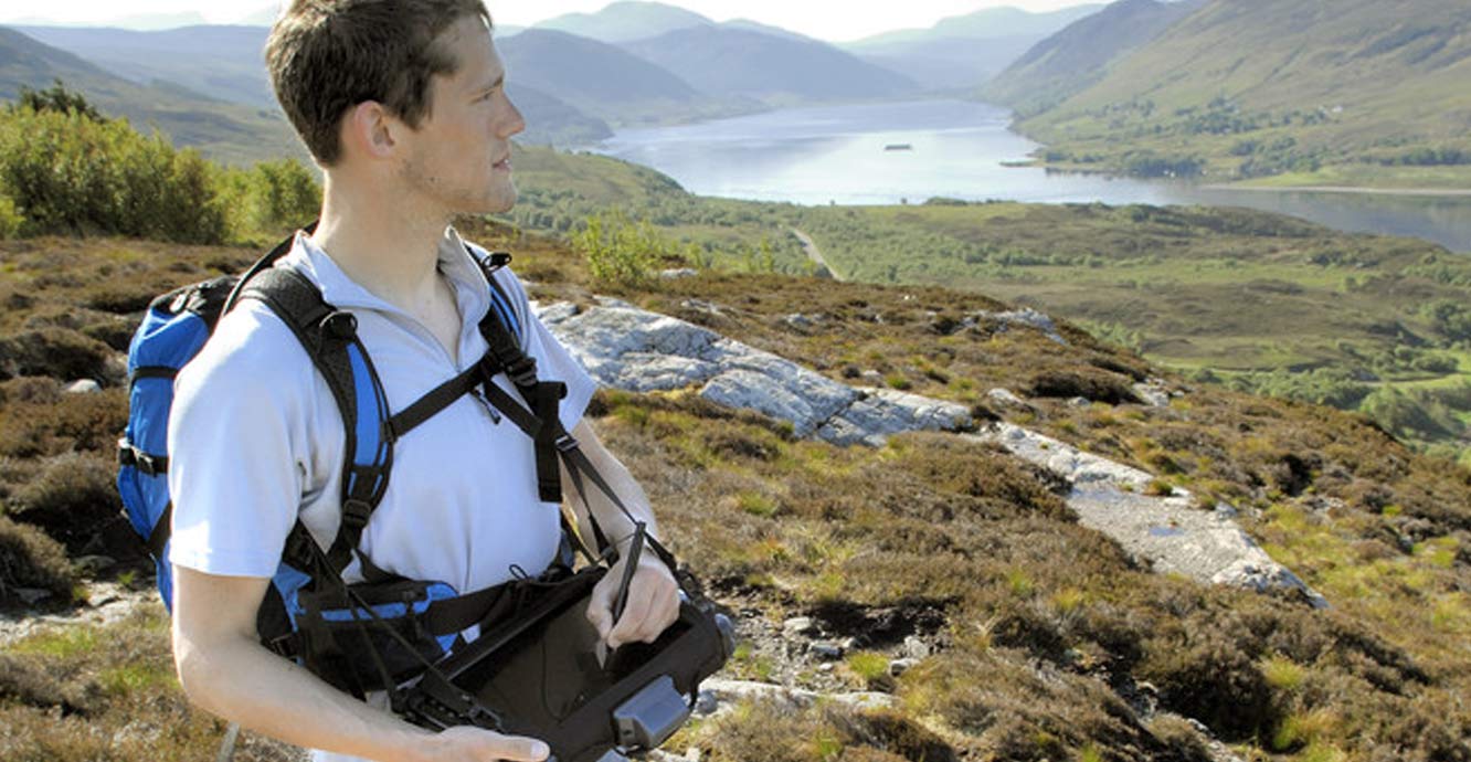
The system is comprised of two customised ESRI ArcMap toolbars: BGS·SIGMAmobile and BGS·SIGMAdesktop. BGS·SIGMAmobile is designed for digital data capture and mapping in the field using ruggedised tablet PCs, while BGS·SIGMAdesktop has tools for data interrogation, data interpretation and the generation of finalised data and products. These end products could be datasets, maps or 3D models.
Benefits of using BGS·SIGMA
The benefits of digital data capture using BGS·SIGMA are extensive. The system enables data to be gathered in a standardised format through the use of a custom-built data model and pre-defined dictionaries. A wide variety of geological information, photographs, sketches and comments are easily collected through the use of tailor-made data-entry forms and all data is linked to a digital location point on the map.
The system enables project teams to start building their digital geological map in the field by merging data collected by multiple geologists, building line work and polygons, and subsequently identifying areas for further investigation. This digital data can then be easily incorporated into corporate databases and used in 3D visualisation software such as GeoVisionary once back in the office.
Quick links
FAQs
BGS·SIGMA is the default toolkit within the BGS for bedrock and superficial mapping as well as other data acquisition projects across the UK and overseas. It is also being successfully used worldwide by:
- geological surveys including Norway, Sierra Leone and Tanzania
- universities including Leicester, Keele and Kyoto
- mining organisations in Brazil and the USA
Its use is global, with nearly 5000 free licenses granted worldwide to date and has been used on all seven continents.

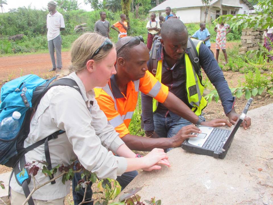
BGS·SIGMA in use around the globe: in a Malaysian hotel and on location in Sierra Leone.
The fourth release of the BGS·SIGMA system contains these updates:
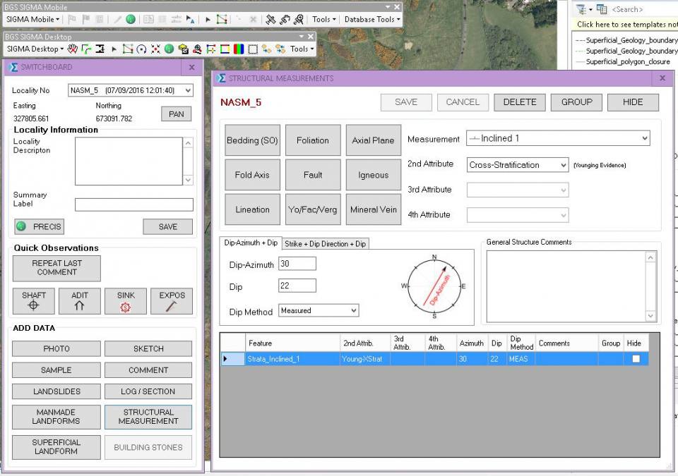
- all data entry forms are now in ESRI ArcMap, allowing for a more streamlined interface for data entry as well as an increase in the speed and efficiency of the system
- redesigned data entry forms, resulting in improved data entry capabilities and ease of use
- all BGS·SIGMAmobile tools are now available from a single toolbar in ESRI ArcMap
- an improved data model
- all main datasets now have feature classes in the geodatabase and all data collection point locations can be viewed in ESRI ArcMap
- improved field report and precis tool
- tools for merging individual databases to create project databases
- grouping of structural data
- a new, redesigned sketch tool
Core functionality
BGS·SIGMAmobile
- Entry of field observation points along with linked data for:
- structural measurements (bedding; faults; folds, etc.)
- superficial landforms (erratics; glacial; periglacial; topographic)
- artificial landforms (adits; shafts; pits, etc.)
- simple log/section
- landslides
- samples
- sketches
- comments
- photos
- Map face notes
- Line data can be drawn directly (and correctly attributed) into ArcMap under these main categories:
- artificial ground
- mass movement
- landforms
- superficial deposits
- bedrock
- Polygon seeds for polygon generation in BGS·SIGMAdesktop
- Field report generator that collates user-defined data into an MS Word document
- Data export tools for using data in other software
BGS·SIGMAdesktop
- Suite of tools to assist in map compilation and decision making:
- combining data from all geologists into one database for generating final data compilation for the project
- cleaning linework
- generating polygons (advanced licence required)
- add more data/hide data
These tools can be used in whichever way suits the user and still maintains the user’s own working practice.
BGS·SIGMAv2015 is designed to run on any 64 bit Windows 7 or Windows 10 PC or tablet PC running:
- ArcGIS 10.1 or 10.3
- MS Word
- 8Gb RAM (BGS recommendation)
An MS Access licence is no longer required, unless your organisation wishes to view and manipulate the data directly in the database or make changes to the dictionaries.
The BGS does not supply ESRI ArcMap or MS Access as part of BGS·SIGMA. It requires a Standard ArcMap licence to run.
BGS currently maintains two types of hardware for digital field-data collection:
Prior to commencing fieldwork, a BGS geologist will carry out an initial desk study of their field area using Socetset (a stereo aerial photography system) or GeoVisionary (3D visualisation software) and observations are recorded directly into ArcMap/BGS·SIGMA. Once datasets have been assembled in the office using BGS·SIGMAdesktop, targeted fieldwork can commence using BGS·SIGMAmobile.
Following fieldwork, BGS·SIGMAdesktop can be used again to finalise data, combine field projects and compile final datasets. As part of this process, GeoVisionary can once again be used to validate the data in a 3D environment.
The BGS·SIGMA project was initiated in 2001 in response to a major stakeholder review of onshore mapping within the BGS. That review proposed a significant change, with the recommendation that digital methods should be implemented for field mapping and data compilation. As digital data became more readily accessible, it meant that paper maps, fieldslips, satellite imagery, aerial photography and other resources could be made available for the area of study. GIS software was evolving and meant we could embed custom built GIS tools into ESRI ArcMap, meaning that, in essence, BGS·SIGMAmobile became the access route to the digital fieldslip with the underlying database becoming the digital notebook.
As BGS·SIGMA evolved over the years it adapted and developed to meet the needs of our geologists. BGS·SIGMAdesktop was added as a toolbar from another piece of BGS-developed software, to make the digital fieldslip into a geological map.
Once the geological data has been collated and finalised, it’s not just maps that can be created: the information can be used in 3D platforms, such as GeoVisionary and GSI3D, and can be used for subsurface interpretation using BGS Groundhog.
We are now developing a BGS▪SIGMA app to compliment the main BGS▪SIGMA system enabling the flexibility to capture of data on a smartphone as well as a tablet or PC.
Yes!
Whilst the system was initially built to replicate traditional geological survey mapping at the BGS, we have successfully designed and developed data entry forms for use by our geodiversity, landslides and buildings stones teams, enabling them to carry out vital work within their areas of expertise.
Outside the BGS, we have developed specialised custom forms for use by mining companies and other organisations (e.g. the built heritage sector, enabling digital condition surveys of traditional or historic buildings).
The core components of the BGS·SIGMA system (observation points; photographs; sketches; samples; comments) apply to most areas of digital data capture and integrating custom requirements into the system can be carried out by our team of specialist developers.
BGS·SIGMAv2015 is available as a free download to anyone who wishes to use it. If you require help in implementing the system within your organisation we can assist.
- We offer standard or customised training courses to suit your organisation.
- Our developers can design, develop and integrate new, customised data entry modules specific to your organisation’s needs.
- Our digital data solutions experts can assist in integrating BGS·SIGMA into your existing digital workflow or help you design a new workflow.
- We can advise on modifying the system to utilise dictionaries and symbology specific to your organisation or country.
- We can help to migrate data collected in previous versions of BGS·SIGMA (versions 2012 and earlier).
Licensing
BGS·SIGMAv2015 is available free for use by commercial and non-commercial organisations.
Please read and accept the licence agreement before downloading.
All databases created in the previous version of BGS·SIGMA (v2012) can be viewed in this new system using the import database tool, but they cannot be edited and all new work must be done in the new v2015 database due to changes in the system.
BGS·SIGMAv2015 download contents
The downloads comes as a .zip file containing:
- BGS·SIGMAv2015 installation files (versions for ArcGIS 10.1 and ArcGIS 10.3 — please install the relevant version)
- a brief installation guide
- a ‘What’s new’ guide
- user manual
To download BGS·SIGMA please complete the form.