Standardised framework provides assessment of carbon dioxide storage site readiness
Geoscientists have developed a practical framework for assessing the degree of ’readiness’ of a prospective carbon dioxide storage site.
28/10/2021 By BGS Press

A practical framework for assessing the degree of ’readiness’ of a prospective carbon dioxide (CO2) storage site, drawing on decades of North Sea basin experience, has been shared in a new paper published by the International Journal of Greenhouse Gas Control.
Geoscientists from the ALIGN-CCUS project have developed a framework of CO2 Storage Readiness Levels (SRLs), which capture the entire picture of technical appraisal, permitting and planning activities for a potential storage site and what must be completed before it can become operational.
The framework is based on the national CO2 storage portfolios of the UK, Norway and the Netherlands, which represent 742 saline formation and hydrocarbon field sites. However, the methodology can be applied to a potential storage site at whatever stage of appraisal anywhere in the world.
The system has allowed a comparison of investment levels and the amount of appraisal time required to achieve a permit-ready North Sea CO2 storage site.
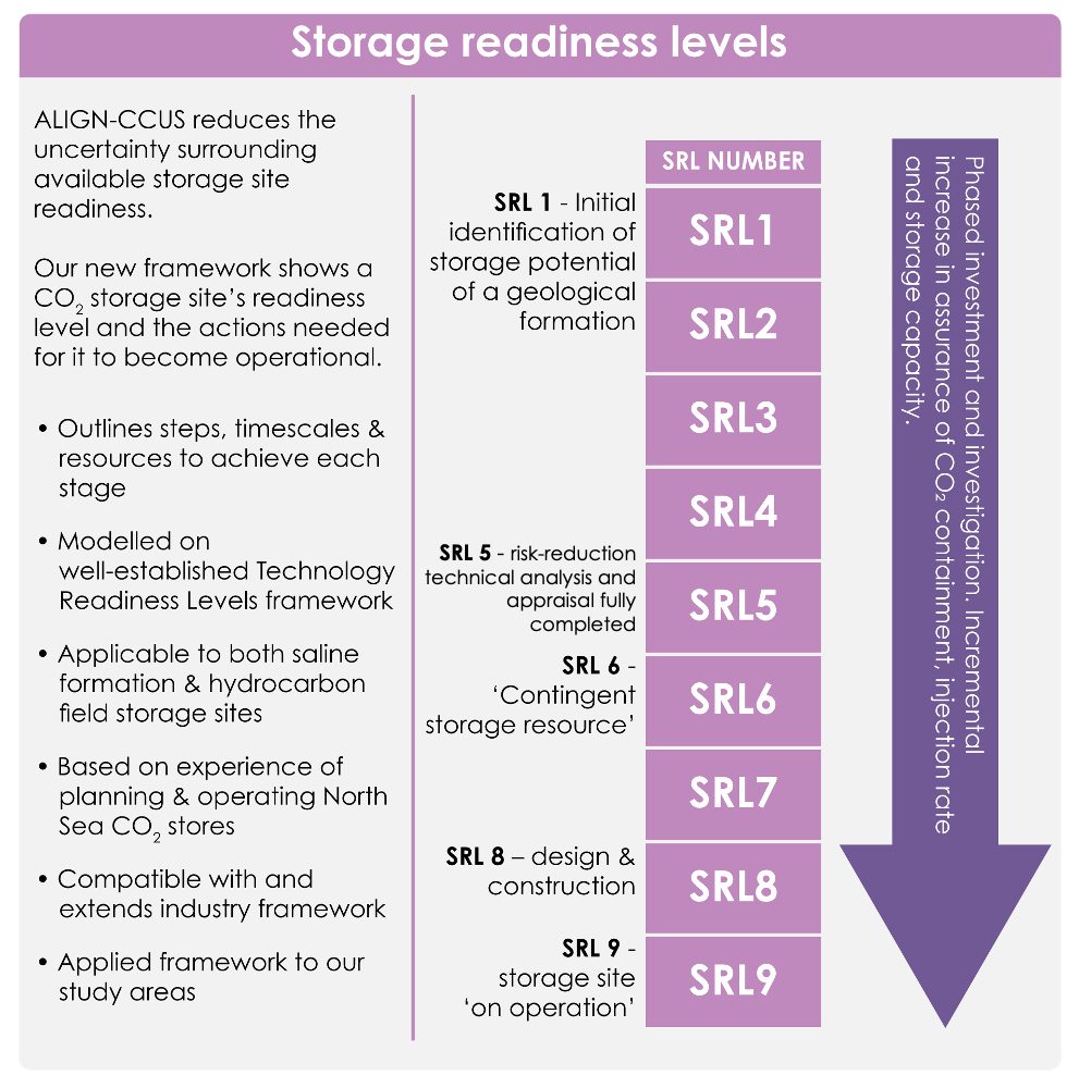
Storage Readiness Levels show the actions that need to be taken for a storage site to be ready for operation. © ALIGN-CCUS/MJD Design.
The researchers took inspiration from Technology Readiness Levels (TRLs), which are used to mark progress in the development of an innovative technology from inception to commercial delivery.

Objectivity is very important for scientific research so we completed our framework first before applying it to the portfolio of prospective and planned sites in each of our countries.
Our system of nine levels benefited greatly from discussion with regulators and offshore industry representatives, which ensured the progression through the SRLs is consistent with the licensing steps required by European legislation. It also ensured that our SRLs are consistent with industry management systems.
Learning from North Sea experience gives realistic estimates of the time and cost needed to bring a site to operational storage and so increase the confidence of investors and operators.
Dr Maxine Akhurst, lead author from the British Geological Survey.
The multidisciplinary ALIGN-CCUS project, which concluded last year, was funded through the EU’s ERA-NET ACT programme to help transform six European industrial regions into economically robust, low-carbon centres by 2025.
Relative topics
Related news

Isotopes and science: my student placement at BGS
08/04/2026
Industrial placements at BGS for undergraduate students give real-life experience of working in laboratories and learning different analytical techniques.

Updated geological assessment of the Southern North Sea set to underpin future offshore infrastructure development
25/03/2026
The first regional assessment for 30 years will support offshore marine and subsurface planning for the UK’s low-carbon energy infrastructure, including the 2030 target of 45 to 50 GW generated through offshore wind.

New research could help provide a more reliable water supply for millions in rural Africa
24/03/2026
A new BGS-led study has revealed crucial insights into the longstanding challenges affecting the reliability and performance of rural water supply infrastructure in sub-Saharan Africa.

Call for new members and Chair to join the NERC facilities steering committees
25/02/2026
New members are needed to join the committees over the next four years.

Your views wanted: developing a geothermal energy subsurface data portfolio
24/02/2026
BGS is aiming to support the growth of the sector by providing the best-available, location-specific geothermal and ground source heat information as an accessible product or service.

Map of BGS BritPits showing the distribution of worked mineral commodities across the country
18/02/2026
BGS’s data scientists have generated a summary map of the most commonly extracted mineral commodities by local authority area, demonstrating the diverse nature of British mineral resources.

Funding awarded to map the stocks and flows of technology metals in everyday electronic devices
12/02/2026
A new BGS project has been awarded Circular Electricals funding from Material Focus to investigate the use of technology metals in everyday electrical items.

New UK/Chile partnership prioritises sustainable practices around critical raw materials
09/02/2026
BGS and Chile’s Servicio Nacional de Geología y Minería have signed a bilateral scientific partnership to support research into critical raw materials and sustainable practices.

Extensive freshened water confirmed beneath the ocean floor off the coast of New England for the first time
09/02/2026
BGS is part of the international team that has discovered the first detailed evidence of long-suspected, hidden, freshwater aquifers.

Funding secured to help mitigate ground risk in UK construction sector
05/02/2026
The BGS Common Ground project has been awarded new funding to help unlock the value of ground investigation data.

Can sandstones under the North Sea unlock the UK’s carbon storage potential?
02/02/2026
For the UK to reach its ambitious target of storing 170 million tonnes of carbon dioxide per year by 2050, it will need to look beyond the current well-studied geographical areas.

Quaternary UK offshore data digitised for the first time
21/01/2026
The offshore wind industry will be boosted by the digitisation of a dataset showing the Quaternary geology at the seabed and the UK’s shallow subsurface.