Landslides triggered by Storm Ciara and Storm Dennis in the UK
On Sunday 9 February 2020, Storm Ciara hit the UK with very high winds and intense rainfall causing widespread disruption and flooding.
21/02/2020 By BGS Press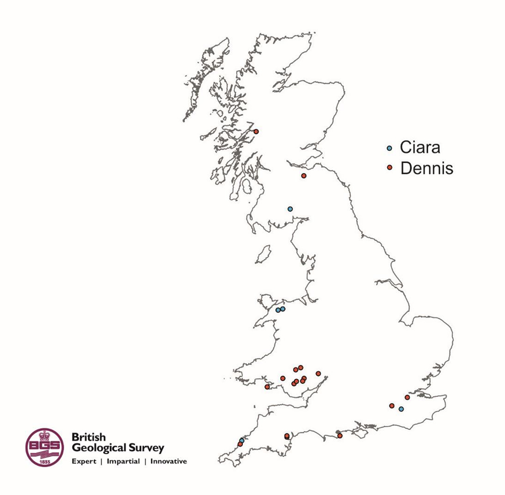

On Sunday 9 February 2020, Storm Ciara hit the UK with very high winds and intense rainfall causing widespread disruption and flooding.
Regions particularly affected were southern and northern England, including the Pennines, and North Wales. Six landslides were reported to us as a result of Storm Ciara.
On Saturday 15 February, Storm Dennis impacted the UK with two days of widespread strong winds and particularly heavy rain. Areas most affected were catchments in South Wales and several areas of England. To date, 32 landslides have been reported to us as result of Storm Dennis.
Reports are coming in every few hours and we expect there to be further information in the coming days and weeks. For more information visit this section.
The map gives an indication of the landslides currently reported and entered in the National Landslide Database following Storm Ciara and Storm Dennis to date.
*Please note that there appears to be five landslide points in blue as opposed to six. This is because two are very close together.
Relative topics
For further details or to arrange media interviews please contact:
Sarah Nice, British Geological Survey Press Office, Keyworth, Nottingham, NG12 5GG
Office: +44 (0)115 936 3605
Mobile: +44 (0)7989 115 657
E-mail: sebr@bgs.ac.uk
Twitter @Sarahnice1
Notes to Editors
Available for interview:
Ashley Patton (BGS landslides team, Wales)
Vannessa Banks (BGS landslides team, Keyworth)
British Geological Survey
The British Geological Survey (BGS) is a world leading applied geoscience research centre that is part of UK Research and Innovation (UKRI) and affiliated to the Natural Environment Research Council (NERC). BGS core science provides objective and authoritative geoscientific data, information and knowledge to inform UK Government on the opportunities and challenges of the subsurface. It undertakes national and public good research to understand earth and environmental processes in the UK and globally. The BGS annual budget of approximately £60 million pa is funded directly by UKRI, as well as research grants, government commissions and private sector contracts. Its 650 staff work across the UK with two main sites, the head office in Nottingham and Lyell Centre, a joint collaboration with Heriot Watt University in Edinburgh. BGS works with more than 150 private sector organisations, has close links to 40 universities and sponsors about 100 PhD students each year. Please see www.bgs.ac.uk.