New maps reveal heat stored in Britain’s abandoned coal mines
BGS and the Coal Authority have released maps which for the first time, reveal the extent to which heat is stored in Britain’s abandoned coal mines.
01/12/2020 By BGS Press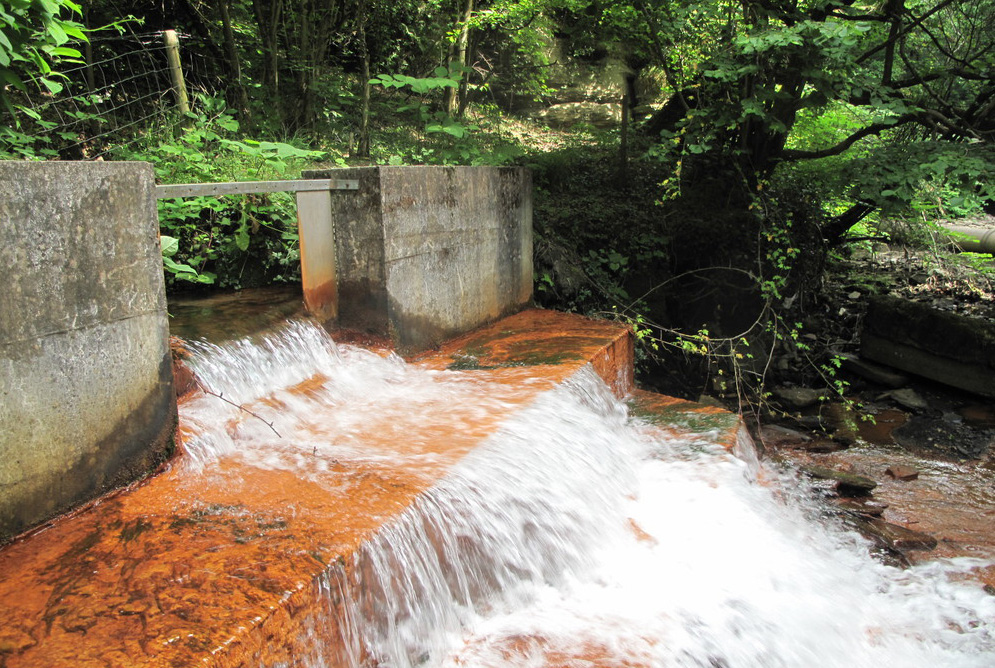

According to the Coal Authority, one quarter of the UK’s population live above abandoned coal mines. The mines are warmed by natural geothermal processes and flooded parts of the mines are now being developed as a source of low-carbon energy to heat homes and businesses.
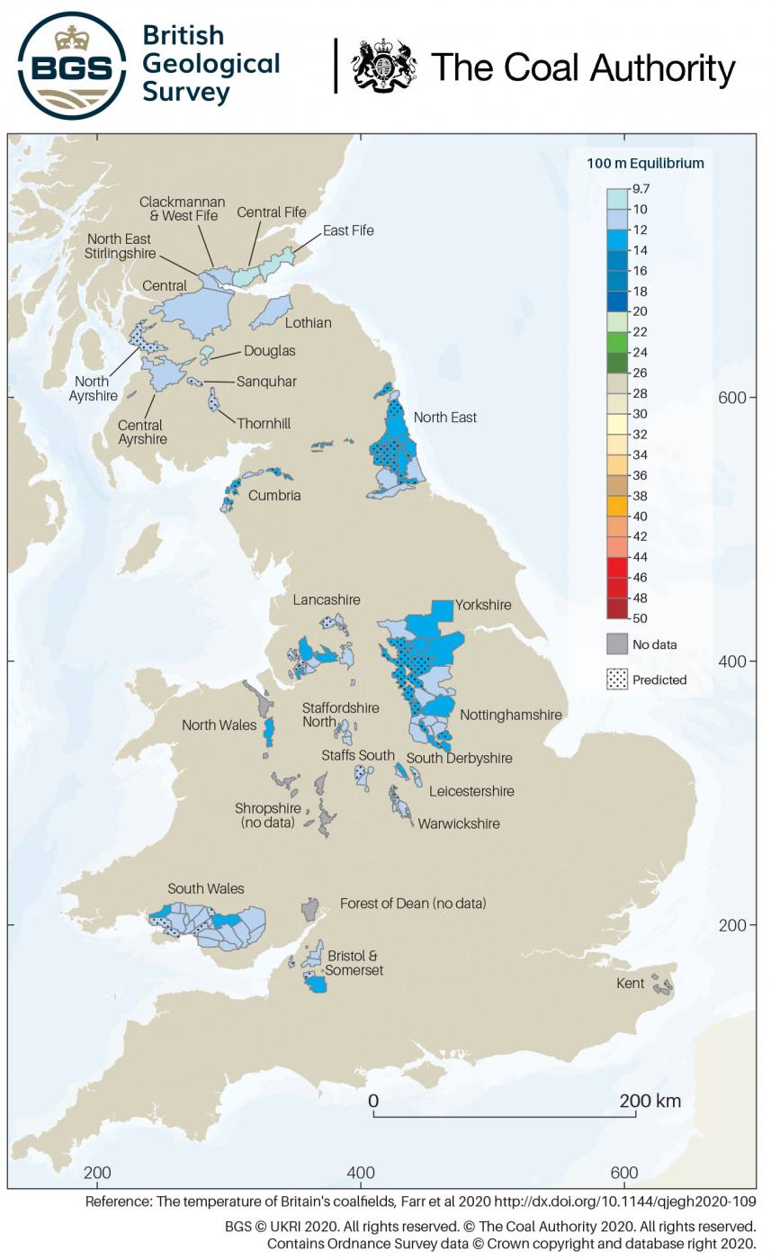
BGS and the Coal Authority have released maps revealing the extent to which heat is stored in Britain’s abandoned coal mines. BGS © UKRI 2020. © The Coal Authority 2020. Contains Ordnance Survey data © Crown copyright and database right 2020.
To understand its potential more effectively, BGS and the Coal Authority have released an interactive map showing where the mines are and the extent by which temperatures increase with depth. The new mapping tool will be freely available to use by developers, planners and researchers to identify opportunities to investigate the use of mine water as a sustainable heat source. Visit the interactive map viewer.
It is the first time the data has been brought together in this way, and illustrates the long-term feasibility of heating homes and buildings using this zero-carbon energy source.

This has been a very exciting piece of work. It’s the first time we have been able to visualise the temperature of Britain’s coalfields. We have found records of heat temperatures going back over 100 years and compared them to temperatures in the mines now, and found them to be quite similar. This is a clear indication that geothermal processes that create this heat will be here for a long time to come.
Combined with other layers of data, the maps provide an important groundwork for developers, local authorities and scientists to explore new minewater heating schemes, and we are hopeful they will be of value to inform policy decision making.
Project leader Gareth Farr, BGS geoscientist
The UK government has a target to increase the number of homes on heat networks from 2% to 18% by 2050. It is recognised that geothermal energy from mines, combined with heat pump technology, could provide a sustainable energy source for these networks that is both local and low cost.
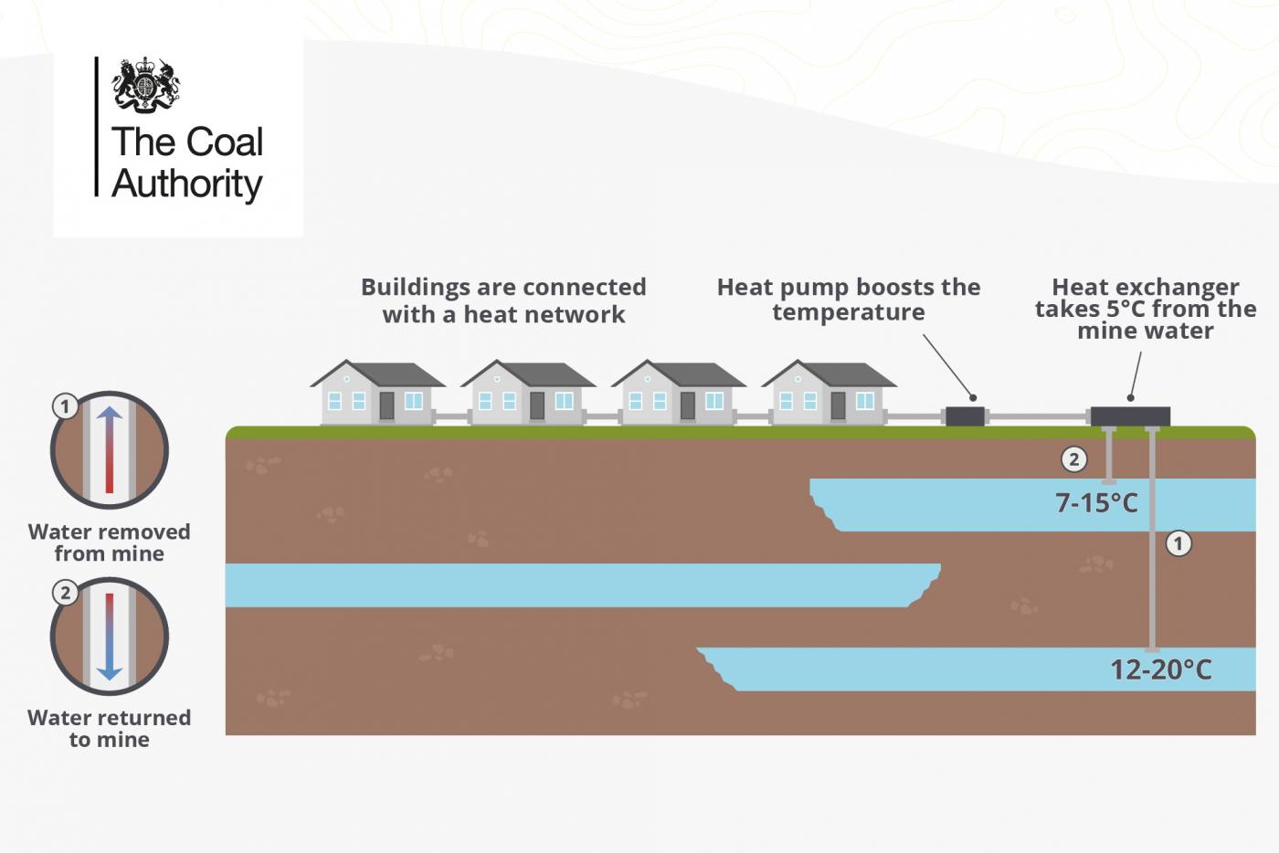
This infographic from the Coal Authority illustrates the potential to utilise minewater energy to heat buildings and homes. © The Coal Authority 2020.
Technical specialists at the Coal Authority say there is potential to kick-start a new renewable industry, creating employment, tackling climate change and attracting investment to the coalfield communities previously disadvantaged by mine closures.
When aligned with the government’s Ten Point Plan for a green industrial revolution, the warm water in abandoned coal mines is now being seen as a viable new form of sustainable energy with the potential to play a vital role in making homes and public buildings greener, warmer and more energy efficient.
When miners were working in hot, dusty conditions, they would not have known that their efforts and the heat they worked in, would one day create a sustainable source of energy for hundreds of years to come.
We are currently reviewing over thirty potential heat network opportunities using geothermal mine energy. Seaham Garden Village and Gateshead are the first two such schemes to secure funding from the government’s £320 million Heat Network Investment Programme, with others to follow.
Jeremy Crooks, The Coal Authority’s Head of Innovation
The interactive maps highlight areas where warm water has been abstracted by pumping, creating opportunities to harvest heat without drilling into the workings.
Crooks added:
Heating accounts for 44 per cent of energy use in the UK and 32 per cent of its air pollution. It’s ironic that mining coal, a fossil fuel, would provide access to a low carbon, clean air, energy source that will last far longer than the 200 years of intensive mining that created this opportunity. The maps we’ve jointly produced is a visual indication of how real and exciting this opportunity is.
The research behind the maps is published in an open access paper by the Quarterly Journal of Engineering Geology and Hydrogeology.
Relative topics
For media enquiries relating to geothermal processes and the research behind the maps please contact Hannah Pole, BGS press office: hapo@bgs.ac.uk | 07565 398 132
Available for interview: Gareth Farr, British Geological Survey (Cardiff)
For media enquiries relating to the development of heat networks, including information about Seaham Garden Village and Gateshead, or the future potential for heating from mine water, please contact Shirlene Campbell-Ritchie, Coal Authority’s communications and engagement team: communications@coal.gov.uk | 01623 637437
Available for interview: Jeremy Crooks, the Coal Authority (Mansfield)
Notes to Editor:
The maps can be viewed on The Coal Authority interactive map viewer.
Full open access paper published in the Quarterly Journal of Engineering Geology and Hydrogeology.
- As the UK moves towards a low carbon, clean growth economy, it will need to significantly reduce its greenhouse gas emissions to meet an ambitious target of net zero for all greenhouse gasses by 2050.
- Currently, heating in homes, businesses and industrial processes is responsible for a third of the UK’s greenhouse gas emissions.
- Following the closure of the majority of the British underground coal mines during the 1980s-1990s, the requirement to dewater ceased and many collieries were left to become flooded.
- Heat recovery and storage in Britain’s coal mines is still in its infancy and many challenges need to be addressed including: the ownership of heat, identification of flooded workings, development of regulatory and licensing frameworks and costs.
- A bespoke ‘geo-observatory’ is being constructed in Glasgow as part of the UK Geoenergy Observatories (UKGEOS) programme to address scientific questions associated with sustainable use of abandoned mines for low enthalpy heat recovery and storage.
- The data sources used to create the map include; Coal Authority downhole temperature profiles from boreholes and shafts, data from the BGS UK Geothermal Catalogue and historic in-situ strata temperatures measured in operational coal mines.