New geological map of the Maltese Islands published
The new map, commissioned by Malta’s Continental Shelf Department, is the first update for almost 30 years.
19/12/2022 By BGS Press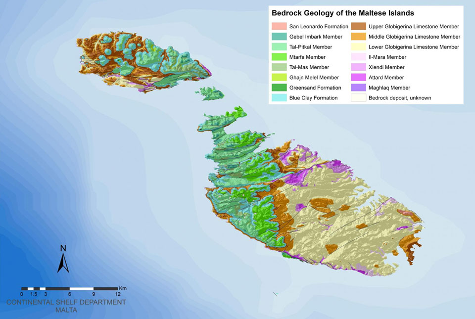

An updated geological map of the Maltese Islands was published last week by Malta’s Continental Shelf Department following a contract awarded to BGS in 2021. The new map is the first update for almost 30 years.
BGS has been surveying the Maltese Islands over the last two years, conducting several field surveys between 2021 and 2022. The new geological map is the first update since 1993 and, at a scale of 1:10 000, is over twice the resolution of its predecessor.
The map is available free of charge through the Continental Shelf Department website. Users can navigate the interactive map through seven different themes, or layers, that define the island’s geological landscape. A GIS version of the new map is also available to download in shapefile format.

Working with the Continental Shelf Department in Malta on an updated geological map of Malta has been a wonderful opportunity for BGS to use its longstanding experience and expertise in surveying and mapping. We hope the updated dataset will be of great benefit to those with an interest in the geology of Malta over the coming years.
Dr David Schofield, director of BGS National and International Geoscience.
The resurveying of the Maltese Islands at a scale of 1:10 000 by BGS represents a significant contribution to the geological mapping of the Maltese Islands. Working with the BGS team over the past two years has been a positive experience with fruitful discussions and exchanges of information leading to a more detailed interpretation of the geology of the Maltese Islands.
Albert Caruana, director general, Continental Shelf Department, Malta.
Relative topics
Related news

Call for new members and Chair to join the NERC facilities steering committees
25/02/2026
New members are needed to join the committees over the next four years.

Your views wanted – developing a ‘Geothermal energy subsurface data portfolio’
24/02/2026
BGS is aiming to support the growth of the sector by providing the best-available, location-specific geothermal and ground source heat information as an accessible product or service.

Map of BGS BritPits showing the distribution of worked mineral commodities across the country
18/02/2026
BGS’s data scientists have generated a summary map of the most commonly extracted mineral commodities by local authority area, demonstrating the diverse nature of British mineral resources.

Funding awarded to map the stocks and flows of technology metals in everyday electronic devices
12/02/2026
A new BGS project has been awarded Circular Electricals funding from Material Focus to investigate the use of technology metals in everyday electrical items.

New UK/Chile partnership prioritises sustainable practices around critical raw materials
09/02/2026
BGS and Chile’s Servicio Nacional de Geología y Minería have signed a bilateral scientific partnership to support research into critical raw materials and sustainable practices.

Extensive freshened water confirmed beneath the ocean floor off the coast of New England for the first time
09/02/2026
BGS is part of the international team that has discovered the first detailed evidence of long-suspected, hidden, freshwater aquifers.

Funding secured to help mitigate ground risk in UK construction sector
05/02/2026
The BGS Common Ground project has been awarded new funding to help unlock the value of ground investigation data.

Can sandstones under the North Sea unlock the UK’s carbon storage potential?
02/02/2026
For the UK to reach its ambitious target of storing 170 million tonnes of carbon dioxide per year by 2050, it will need to look beyond the current well-studied geographical areas.

Quaternary UK offshore data digitised for the first time
21/01/2026
The offshore wind industry will be boosted by the digitisation of a dataset showing the Quaternary geology at the seabed and the UK’s shallow subsurface.

Suite of ten new soil reference materials released
02/01/2026
BGS has a longstanding track record of producing high-quality reference materials and has released ten new soil reference materials.
Perth and Kinross tops the UK’s earthquake activity charts for 2025
29/12/2025
Seismologists at BGS have published data on the number of seismic events over the past 12 months with over 300 earthquakes recorded.

BGS awarded funding to support Malaysia’s climate resilience plan
17/12/2025
The project, funded by the Foreign, Commonwealth & Development Office, will focus on minimising economic and social impacts from rainfall-induced landslides.