‘First of its kind’ online tool created to help tackle pollution in London
The new Road Pollution Solutions tool predicts pollution levels from road runoff and suggests nature-based solutions to combat it.
04/09/2023 By BGS Press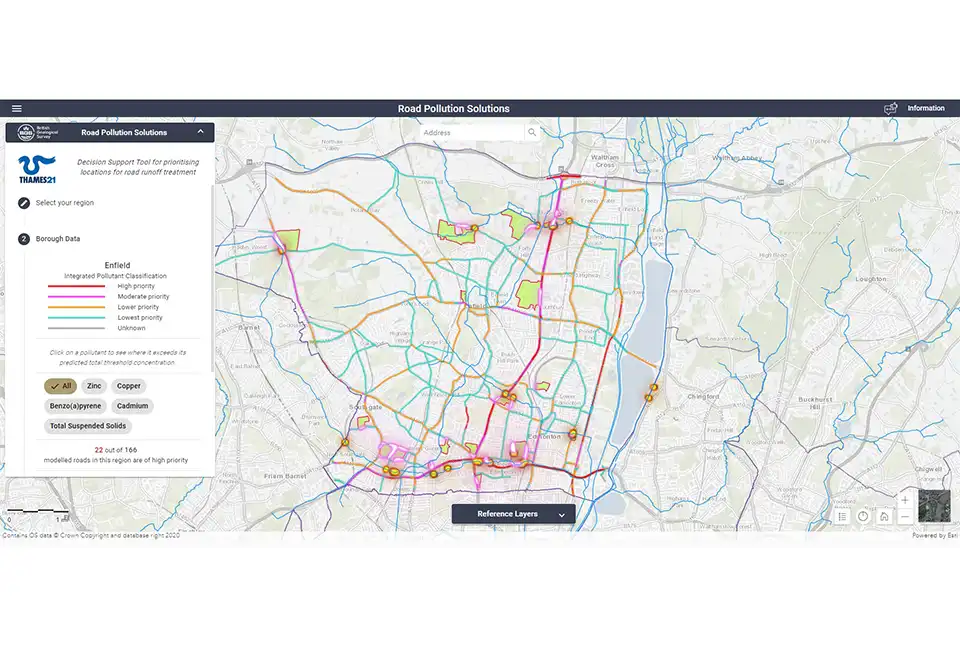

BGS’s new, first of its kind online tool, Road Pollution Solutions, has gone live today (4 September 2023) and predicts which roads in London create the most runoff pollutants and how this can be tackled with nature-based solutions. The tool will help local authorities to prioritise water-quality improvement interventions at roads where major road runoff pollution is occurring and in the greenspaces that lie between the roads and the rivers.
Road runoff pollution in rivers and streams comes from oil, diesel and petrol spills as well as the wearing of roads, tyres and braking systems. These all leave residues and sediment that are washed off the roads and into waterways by rain. Roads where heavy goods vehicles regularly apply their brakes are often the worst affected.
Modelling shows that more than 2400 road sections covering a total of 451 km of London’s major roads pose a high risk of causing road runoff pollution. These roads are the priority for treatment, with natural barriers, such as wetlands, being used to help capture and prevent some of this road runoff pollution from entering rivers and streams.
The London boroughs ‘predicted’ to have the most polluting roads include:
- Barking and Dagenham
- Barnet
- Havering
- Haringey
- Waltham Forest

We have been delighted to work with Thames21 and its partners to create the Road Pollution Solutions tool. It will help local authorities and anyone seeking to improve our water environment to quickly identify the major sources of pollution from roads and to prioritise interventions to tackle them. Nature-based solutions have multiple benefits and we expect the tool to speed up their implementation.
Chris Jackson, BGS Head of Environmental Modelling
Road Pollution Solutions is built on years of research by environmental charity Thames21 and its partner Middlesex University, as well as the South East Rivers Trust. The charity started its initial road runoff project identifying key polluting London roads in 2019, with funding help from the Greater London Authority, Transport for London and the Environment Agency.
Additional support for the creation of the tool was provided by the UKRI/NERC-funded CAMELLIA project.
- Project delivered by:
- researchers:
- Thames21
- Middlesex University
- South East Rivers Trust
- funders:
- Environment Agency
- Transport for London
- Greater London Authority
- Project supported by:
- Middlesex University
- Zoological Society of London (ZSL)
- CAMELLIA
- Built by: BGS
- researchers:
This study uses numbers of vehicles and vehicle types to predict the amount of pollution deposited on roads and then predicts the degree of damage these contaminants could cause to our rivers. The modelling for this project only applies to the major roads in outer London for which Transport for London has modelled or observed data around vehicle movements. All the roads assessed have potential for damaging river health.
The project assessed six pollutants, five of which have environment quality standards (zinc, cadmium, copper, total suspended solids and benzo(a)pyrene). Pyrene was also modelled as an important indicator of road runoff, though it does not yet have an environment quality standard.
About BGS
The British Geological Survey (BGS) is a world-leading geological survey that undertakes strategic science for the benefit of society. BGS is part of UK Research and Innovation (UKRI) and a research centre within the Natural Environment Research Council (NERC).
BGS delivers research, products and services for the UK, and operates internationally to maximise the impact of its science and to contribute to the UK’s international priorities. BGS is the national centre of geological data and information and undertakes monitoring and analytical research programmes. These enable the timely and authoritative provision of impartial and independent information and advice to governments, industry and civil society.
The new BGS Strategy for 2023 to 2028, ‘Understanding our Earth’, sets out its four priority science areas for the next five years, helping to deliver the necessary geological data and knowledge for a sustainable future. See www.bgs.ac.uk.
Related news

Delving deep into mountains for future water security
16/07/2026
A BGS-led project is using new water-tracing investigation methods, geophysics and modelling to understand how water moves from mountains to the lowlands, helping to improve water security for billions of people.

Collecting beach pebbles: fun hobby but is it legal?
14/07/2026
The UK coastline will be inundated with keen holidaymakers this summer, many of whom will take a memento of their trip home in the shape of a pebble or two — but is it legal?

Updated national 3D model will determine the depth to the solid bedrock beneath our feet
13/07/2026
The BGS Superficial Deposit Thickness Model now includes an elevation model of geological rockhead for the first time, providing important data for civil engineers, geoscientists and environmental scientists.

UK’s world-class research organisations launch new collective
10/07/2026
The launch of the National Research Organisations Group brings together more than 100 science leaders to provide an authorativive voice on science, research policy and long-term investment.

Cheshire Geoenergy Observatory releases key geological datasets for UK thermal energy storage scheme design
09/07/2026
A new report and data packs from BGS will provide a unique resource for scientists working on the geology and hydrogeology of the Sherwood Sandstone Formation, an important aquifer and reservoir rock.

New geological mapping underway to help manage flooding along the River Tweed
08/07/2026
Scientists are surveying the Tweed catchment for the first time in over 100 years to enhance understanding of localised groundwater and improve flood forecasting.

Geological research in North Sea helping to safeguard subsea cables
06/07/2026
Subsea power and telecommunications cables are critical to the UK’s energy infrastructure and global connectivity, yet they remain vulnerable to damage from ship anchors, fishing activity and natural hazards.

UK Critical Minerals Intelligence Centre makes recommendations for the next UK criticality assessment
01/07/2026
CMIC has outlined the enhancements made to the next assessment update to ensure it is better tailored to the structure of the UK economy.

From archive to discovery: historical mineral reports support gold exploration in Scotland
25/06/2026
Digitised geological records show potential to unlock untapped mineral resources in Ardlochan, Argyllshire.

UK and Philippines scientists investigate natural hydrogen generation processes at atomic scale
22/06/2026
BGS researchers were granted access to use the Diamond Light Source facility in order to study hydrogen in light brighter than the sun.

Shortage of end-of-life materials presents challenge to UK critical minerals security
17/06/2026
A new report by the UK Critical Minerals Intelligence Centre reveals insufficient end-of-life material stocks present a supply risk over the coming decade, but offer significant long-term potential to meet critical mineral demand through recycling.

UK geothermal catalogue receives update
16/06/2026
BGS releases the second digital version of the UK geothermal catalogue of subsurface temperature and rock thermal conductivity measurements and heat flow calculations.