Ascension Island is a subtropical volcanic island in the South Atlantic, rising 4 km from the sea floor to a height of 859 m above sea level with an area of approximately 91 km2. Like all volcanic islands, most of the volcano is below sea level, so the island comprises just the summit and the volcano appears deceptively small.
About the island
Ascension is one of three islands that collectively form the UK Overseas Territory (UKOT) of St Helena, Tristan da Cunha and Ascension. St Helena lies 800 miles to the south-east and Tristan da Cunha 2300 miles to the south of Ascension.
The island was discovered in 1501 but was only settled in 1815. Charles Darwin stopped here on the return trip of the HMS Beagle voyage from the Galápagos in 1836 and inspired James Hooker of Kew Gardens to conduct an ecological experiment in 1843 on the rocky, barren island by terraforming the highest peak, Green Mountain, and creating a tropical cloud forest. Ascension Island has the largest green turtle nesting site in the South Atlantic and, in 2019, the entire Exclusive Economic Zone of Ascension Island was designated a Marine Protected Area.
Despite the amazing fauna and endemic flora of Ascension Island, it has also been dubbed ‘The Mars of the Mid-Atlantic’ and this rocky perspective is due to the volcanic history of the island.
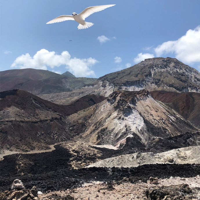

Trachyte lava domes of White Hill in the east of the island, with scoria and lava flows from ‘Devil’s Inkpot’ being observed by a fairy tern. BGS © UKRI
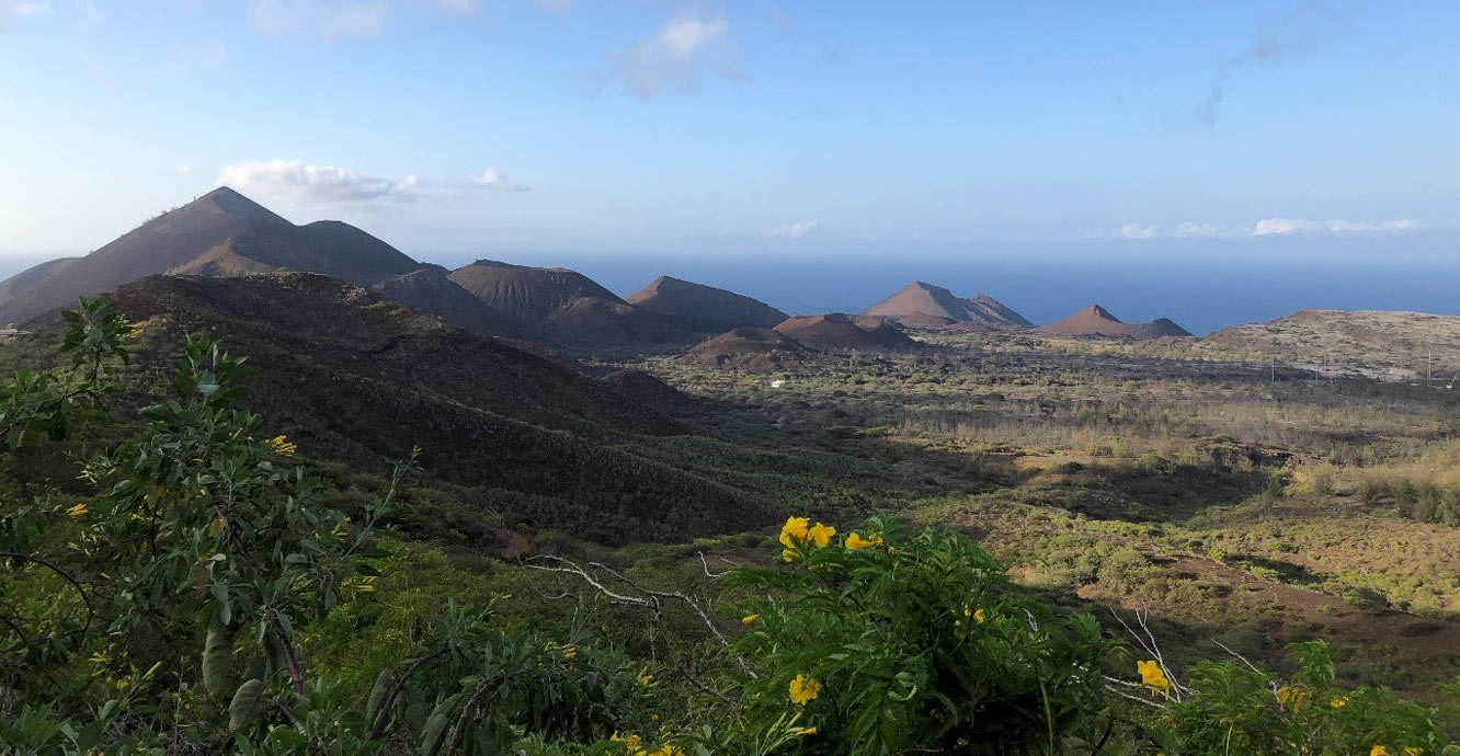
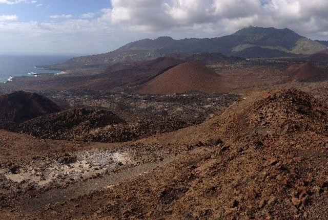
Sisters Peak cinder cone complex viewed from the slopes of Green Mountain. BGS © UKRI.
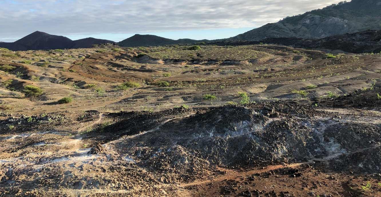
Concentric layers of scoria, pumice fall and sediments within the so-called ‘Devil’s Riding School’, an old weathered trachytic lava dome and one of the locations described by Darwin on his visit to Ascension Island. BGS © UKRI
Volcanic history
Ascension Island’s eruptive history began on the sea floor around six million years ago and the island emerged above sea level in the last one million years. Ascension Island is not associated with a hotspot and the crustal structure cannot be reconciled with a classic intraplate ocean island.
Volcanic activity has been dominated by lava flows produced from vents distributed all over the surface of the island, with less frequent explosive eruptions producing volcanic ash and pyroclastic flows originating from the central and eastern areas.
Green Mountain is the dominant peak on the island. This elevated ground is the result of eruptions of lava domes and flows and associated pumice fall deposits, some of which have been mantled by younger, mafic scoria that forms the highest point. Much of this peak is now vegetated. The southern slopes dip steeply toward the sea, ending in sea cliffs up to 100 m high. The remaining surface of the island is dominated by low-lying plains of rubbly lava flows that are punctuated by more than 45 cinder cones.
There have been at least 74 explosive eruptions in the subaerial history of the island from a series of vents located around Middleton’s Ridge, Green Mountain and the south-eastern side of the island. By contrast, much of the basaltic volcanism has occurred from monogenetic vents distributed on the volcano’s flanks, with little evidence of basaltic activity having occurred within the craters produced by silicic eruptions. One particular site, Sisters Peak, located on the northern side of the island, has been the site of numerous basaltic eruptions including two of the three most recent eruptions that occurred in the last 2000 years (dated as 0.51 ±0.18 ka; 0.55 ±0.12 ka, and 1.64 ±0.37 ka) and an extensive cinder cone complex reflects this history.
BGS research
Our scientists have been working collaboratively on research projects on Ascension Island to investigate the subsurface processes that have controlled the style, size and frequency of volcanic eruptions, establish the frequency-magnitude distribution of past eruptions and better understand the diversity of eruption styles and the volcanic hazards that might occur again.
We have used the volcanic history, eruptive styles and wider geological understanding of the island to co-design a series of volcanic eruption scenarios with the Ascension Island Government. These have been used to provide input data to ash fall hazard models to discuss a range of possibilities and potential impacts if there is an eruption in the future on Ascension.
Research alongside collaborators from the universities of Durham, UEA, Swansea, Derby and Glasgow has contributed to a new understanding of the processes driving explosive volcanic activity on Ascension Island and its timing. Until this research, which began in 2014, Ascension Island had no records of recent Holocene volcanic activity. The BGS and Durham University are producing a new geological map of the island that combines published geochemical and petrographic data and dating with new field data.
As part of the ongoing research, BGS installed a temporary seismic monitoring network on the island from December 2019 – March 2020 and established a water-borehole monitoring station. Our ongoing research and monitoring will enable investigation of the threat from volcanic eruptions and inform long-term planning in partnership with the Ascension Island Government and island stakeholders.
We are currently supporting two PhD projects focusing on Ascension Island:
- Understanding effusive-explosive interactions on Ascension Island, with Durham University, NERC Iapetus DTP
- Assessing the vulnerability of roof collapse in response to loading from volcanic ash with relevance to Ascension Island, with Leeds University, NERC Panorama DTP
BBC News. 2016. Ascension: the island where nothing makes sense. [Online]
Chamberlain, K J, Barclay, J, Preece, K, Brown, R J, and Davidson, J P. 2016. Origin and evolution of silicic magmas at ocean islands: perspectives from a zoned fall deposit on Ascension Island, South Atlantic. Journal of Volcanology and Geothermal Research, Vol. 327, 349–360.
Jicha, B R, Singer, B S, and Valentine, M J. 2013. 40Ar/39Ar geochronology of subaerial Ascension Island and a re-evaluation of the temporal progression of basaltic to rhyolitic volcanism. Journal of Petrology, Vol. 54, 2581–2596.
Nielson, D L, and Sibbett, B S. 1996. Geology of Ascension Island, South Atlantic Ocean. Geothermics, Vol. 25(4–5), 427–448.
Preece, K, Mark, D F, Barclay, J, Cohen, B E, Chamberlain, K J, Jowitt, C, Vye-Brown, C, Brown, R J, and Hamilton, S. 2018. Bridging the gap: 40Ar/39Ar dating of volcanic eruptions from the ‘Age of Discovery’. Geology, Vol. 46(12), 1035–1038.
Contact
If you want to discover more then please contact Charlotte Brown.
You may also be interested in
Volcanology
Our scientists lead research projects and work in partnerships around the world to improve our understanding of volcanic processes, hazards and risks.
Geoscience in the Overseas Territories
The UK’s 14 Overseas Territories (UKOTs) are highly diverse islands, geographically dispersed around the world in different climate zones. Most are small islands that are particularly vulnerable to natural hazards and climate change.