On 17 February 2014, large cracks appeared in a detached house in Ripon and, part of the house later collapsed. The cause of the collapse was due to the formation of a sinkhole resulting from the dissolution of thick gypsum deposits beneath the area.
The sinkhole was roughly oval and measured 11 m from north to south (measured between the crack in the house and a crack across the garden near the greenhouse). From east to west it measured about 15 m. The maximum depression was in the garden between the house and the greenhouse and it appeared to be around 0.7 m deep in the middle. Several cracks up to 5 cm also appeared in the house and paths, delineating the maximum extent of the sinkhole.
There were also slight movements in neighbouring garden walls and driveways with slight lateral movements towards the hole opening cracks of 2 mm to 1 cm.
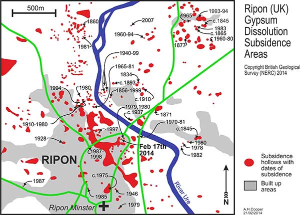

Map of the Ripon area showing the distribution of sinkholes, with the dates of reported collapses. The large areas are amalgamations of sinkholes mainly filled with peat and clay. BGS © UKRI.
Partial house collapse
On the evening of Monday 17 February 2014, Mr and Mrs Cunningham returned home to their house in Magdalen’s Close, Ripon, to find they could not open their back door. They heard noises, looked up and saw that the back of the house was collapsing.
They called the emergency services who broke down the front door and rescued their dog before shutting off utilities to make the house safe from gas, electricity and water problems. Residents of neighbouring houses were also evacuated.
The following morning, the horror of the event was evident with the rear third of the house severely damaged and a crack widening from ground to roof, wrenching the house apart. This crack in the house continued to widen to about 40 cm at the top during the following day, and the press gathered in anticipation of its total collapse. In the garden, the greenhouse subsided and tilted towards the house.
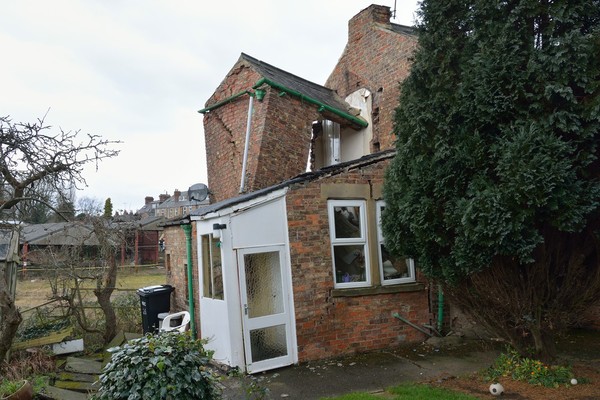
Damage caused to No. 26 Magdalen’s Close, Ripon, by a sinkhole that developed on Monday 17 February 2014. BGS © UKRI.
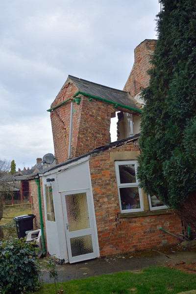
Damage caused to No. 26 Magdalen’s Close, Ripon, by sinkhole that developed on Monday 17 February 2014. BGS © UKRI.
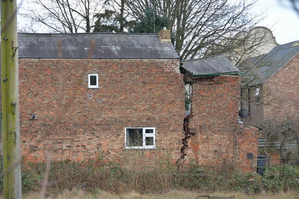
Damage caused to No. 26 Magdalen’s Close, Ripon, by sinkhole that developed on Monday 17 February 2014. BGS © UKRI.
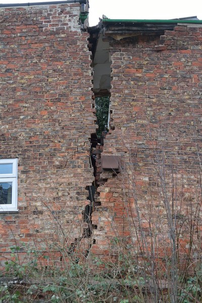
Damage caused to No. 26 Magdalen’s Close, Ripon, by sinkhole that developed on Monday 17 February 2014. BGS © UKRI.
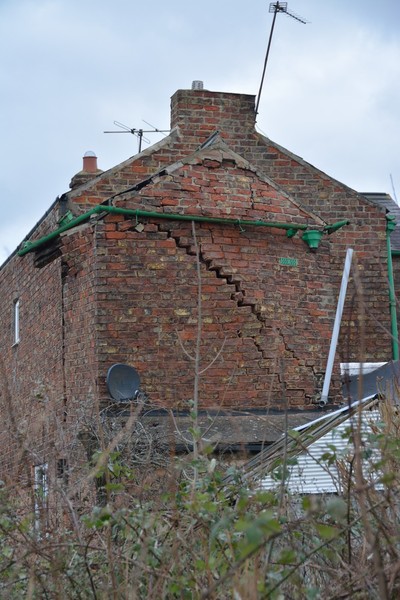
Damage caused to No. 26 Magdalen’s Close, Ripon, by sinkhole that developed on Monday 17 February 2014. BGS © UKRI.
About 40 m to the east-north-east of this sinkhole, a previous sinkhole that collapsed in 1979 and 1980 (Cooper, 1986) also showed slight movement and re-activation cracks in the same place as the previous sinkhole margin.
Gypsum around Ripon
Gypsum (hydrated calcium sulphate) is a highly soluble rock that dissolves very quickly. A gypsum block about 3 m3 that fell from the gypsum cliff at Ripon in 1978 dissolved completely in about 18 months (James et al., 1981).
Underground beneath Ripon, gypsum has dissolved to form a cave system. In caves, however, gypsum tends to dissolve more slowly than in rivers, partly because of the generally slower water flow and partly because the water gets saturated with dissolved gypsum (Klimchouk et al., 1996).
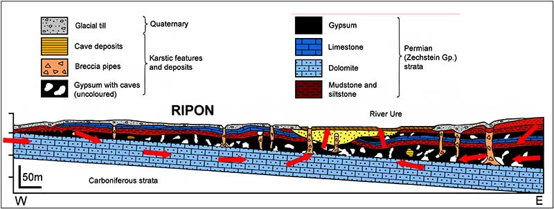
Cross-section through the Ripon area (Cooper et al., 2013) showing the water flow through the bedrock and the stylised subsidence features. BGS © UKRI.
Gypsum cave system
The Ripon caves most likely take a form similar to the gypsum maze caves of Ukraine (Klimchouk, 1992; Klimchouk and Andrejchuk, 1996). Like Ripon, these have thick gypsum deposits resting on a porous and jointed aquifer (which is dolomite in the case of Ripon) and a groundwater flow pushing water through the system, dissolving the gypsum throughout the area.
In Ripon, water flows from the dip slope catchment of the Cadeby Formation dolomite located on the high ground west of Ripon, through the rock to below the gypsum, passing through the gypsum and dissolving it before and emerging as artesian, sulphate-rich springs in the low ground along the River Ure (Cooper et al., 2013). The dissolution and caves are controlled by the joints in the rock and the resultant maze cave can be likened to the reticulate pattern of the bars of a window with hundreds of panes.
The joints in the rock beneath Ripon trend approximately north–south and east–west, defining the orientation of the caves. The water flow under Ripon runs approximately from west to east. At the intersections of the joints the caves become more enlarged and sinkholes are more likely to form at these positions giving the sinkholes a pattern (Cooper 1986, 1998; Klimchouk and Andrejchouk, 2005).
Frequency of sinkole collapse
Ripon periodically gets sinkholes; in the 1980s and 1990s, one was appearing every two to three years (Cooper, 1998). The last recorded hole was on the flood plain of the River Ure, north of Ripon (Sargent and Goulty, 2009). There was then a seven-year gap before this occurrence, which was not an unexpected event.
The triggering mechanisms for these sinkholes to collapse can be singular or a combination of mechanisms, the most common being:
- enlargement of the caves due to subsurface dissolution
- infiltration of water from the surface washing down fine materials from the covering deposits
- fluctuations in the groundwater levels; rising groundwater wets the covering materials and falling groundwater leaves the cover saturated and without hydraulic support
References
Cooper, A H. 1986. Foundered strata and subsidence resulting from the dissolution of Permian gypsum in the Ripon and Bedale areas, North Yorkshire. 127–139 in The English Zechstein and related topics. Harwood, G M, and Smith, D B (editors).
Cooper, A H. 1998. Subsidence hazards caused by the dissolution of Permian gypsum in England: geology, investigation and remediation. 265–275 in Geohazards in Engineering Geology. Maund, J G, and Eddleston, M (editors). Engineering Geology Special Publications 15. (London: Geological Society of London.)
Cooper, A H, Odling, N E, Murphy, P J, Miller, C, Greenwood, C J, and Brown, D S. 2013. The role of sulfate-rich springs and groundwater in the formation of sinkholes over gypsum in Eastern England. 141–150 in Sinkholes and the Engineering and Environmental Imapacts of Karst: Proceedings of the Thirteeth Multidisciplinary Conference, May 6–10. Land, L, Doctor, D , and Stephenson, J B (editors). (Carlsbad, New Mexico, USA: National Cave and Karst Research Institute.)
James, A N, Cooper, A H, and Holliday, D W. 1981. Solution of the gypsum cliff (Permian Middle Marl) by the River Ure at Ripon Parks, North Yorkshire. Proceedings of the Yorkshire Geological Society, Vol. 43, 433–450.
Klimchouk, A. 1992. Large gypsum caves in the Western Ukraine and their genesis. Cave Science, Vol. 19, 3–11.
Klimchouk, A, and Andrejchouk, V. 2005. Karst breakdown mechanisms from observations in the gypsum caves of the Western Ukraine: implications for subsidence hazard assessment. Environmental Geology, Vol. 48, 336–359.
Klimchouk, A, and Andrejchuk, V. 1996. Sulphate rocks as an arena for karst development. International Journal of Speleology, Vol. 25, 9–20.
Klimchouk, A, Cucchi, F, Calaforra, J M, Aksem, S, Finocchiaro, F, and Forti, P. 1996. The dissolution of gypsum from field observations. International Journal of Speleology, Vol. 25, 37–48.
Sargent, C, and Goulty, N R. 2009. Seismic reflection survey for investigation of gypsum dissolution and subsidence at Hell Kettles, Darlington, UK. Quarterly Journal of Engineering Geology and Hydrogeology, Vol. 42, 31–38.
Contact
If you want to discover more then please contact Vanessa Banks.
You may also be interested in
Sinkholes and karst research
Our research extends beyond the distribution and processes associated with sinkhole formation to the broader subject of karst.