On 10 November 2016 the BGS received a call from the emergency planning team of Harrogate Borough Council about a sinkhole at Magdalen Road, Ripon. We sent a multi-skilled responsive team comprising three people to investigate.
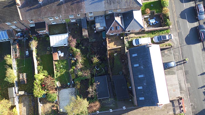

Figure 1: aerial image of the sinkhole using an unmanned aerial vehicle (UAV). BGS © UKRI.
Sinkhole description
On 10 November the sinkhole was reported to be in the order of 10 m in diameter and of unknown depth. By the time of our visit, cracking associated with the sinkhole had extended to almost twice this footprint (Figure 1) and the responsive team estimated the depth to be 5 m. There was no visual evidence of damage to services (Figure 1). The team obtained aerial images of the sinkhole using an unmanned aerial vehicle (UAV) for close-range aerial photography.
Geographical and geological setting
Ripon is a historic city and market town in North Yorkshire. The sinkhole was situated at NGR 431607 471684, on the eastern side of Ripon close to the River Ure.
The geology comprises marls, limestone and gypsum of the Permian Brotherton Formation, capped by glacial deposits (Figure 2). Karst in gypsum (hydrated calcium sulphate) can form water-filled cave systems. The rapid solubility rate of the gypsum means that the karst is evolving on a human time scale (years to decades).
Groundwater flows from the high ground west of Ripon, through the rock and into the gypsum, dissolving the rock as it passes through. It then emerges as artesian, sulphate-rich springs in the low ground along the River Ure. The dissolution features and caves are controlled by the joints in the rock and form the resultant maze of caves.
The joints in the rock beneath Ripon trend approximately north–south and east–west, defining the orientation of the caves. The water flow under Ripon runs approximately from west to east.
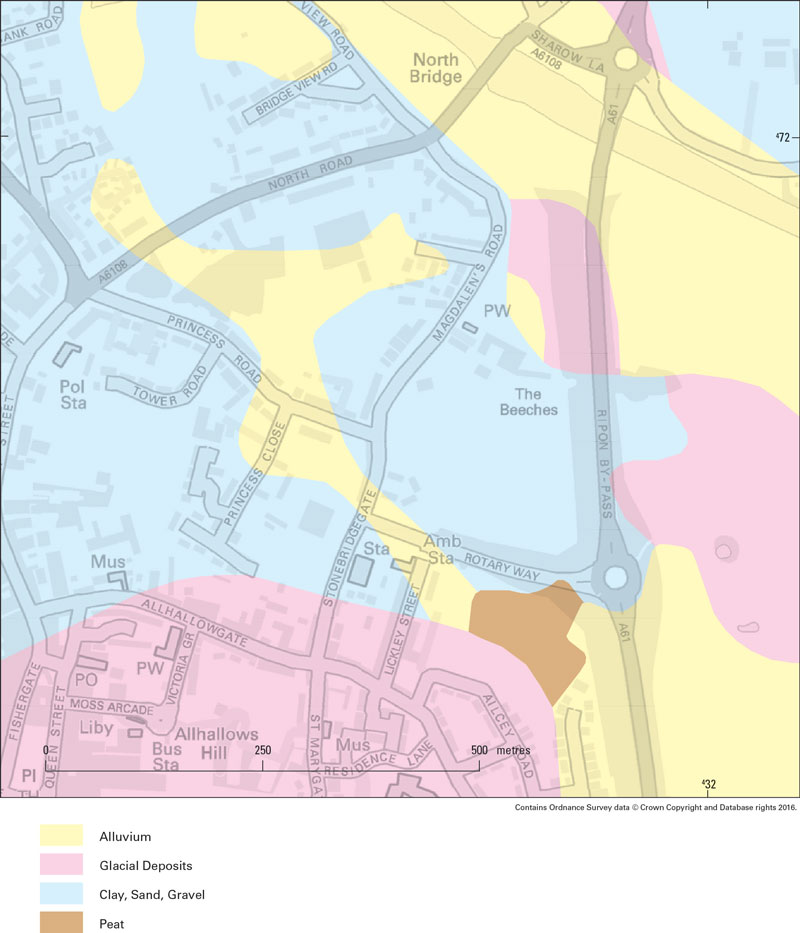
Figure 2: superficial geology of the Ripon area. BGS © UKRI. Contains Ordnance Survey data © Crown copyright and database rights. All rights reserved 2020 Ordnance Survey [100021290 EUL].
Frequency of sinkhole collapse
Previous collapses have occurred close to this sinkhole in 2014, 1979 and 1980. The wider area of Ripon periodically encounters sinkholes; in the 1980s and 1990s, one was appearing every two to three years (Cooper, 1998).
Triggering mechanisms for these sinkholes
The triggering mechanisms for these sinkholes to form can be singular or a combination of mechanisms. The most common mechanisms include:
- enlargement of caves due to subsurface dissolution
- infiltration of water from the surface washing down fine materials from the covering deposits
- fluctuations in the groundwater levels; rising groundwater wets the covering materials and falling groundwater leaves the cover saturated and without hydraulic support
Anthropogenic impacts
Karst environments are also sensitive to anthropogenic impacts, e.g. leaking drainage pipes, burst water mains, irrigation or human-induced changes in groundwater level.
Mitigation
The BGS response team have collected data and information on the event and conditions at the site. They have liaised with Harrogate Borough Council, North Yorkshire Fire and Rescue Service and utility services with respect to ground stability. They will further process and analyse the field data.
References
Cooper, A H. 1998. Subsidence hazards caused by the dissolution of Permian gypsum in England: geology, investigation and remediation. 265–275 in Geohazards in Engineering Geology. Maund, J G, and Eddleston, M (editors). Engineering Geology Special Publication 15. (London: Geological Society of London.)
Contact
If you want to discover more, please contact BGS Enquiries.
You may also be interested in
Sinkholes and karst research
Our research extends beyond the distribution and processes associated with sinkhole formation to the broader subject of karst.