Just as the landscape of Great Britain is diverse, so too are the landslides that reflect the complex geological conditions as well as the variety of geomorphological processes and repeated glaciations experienced over thousands of years. The diversity of both landscapes and landslide processes encountered during our work at national, regional and site-specific scales proved to be a driver to develop a landslide domain map. This map summarises the key characteristics of landslides in a series of hierarchical spatial units (‘domains’) that represent areas of similar physiographical, meteorological, climatic and geological characteristics that shape the style of landsliding.
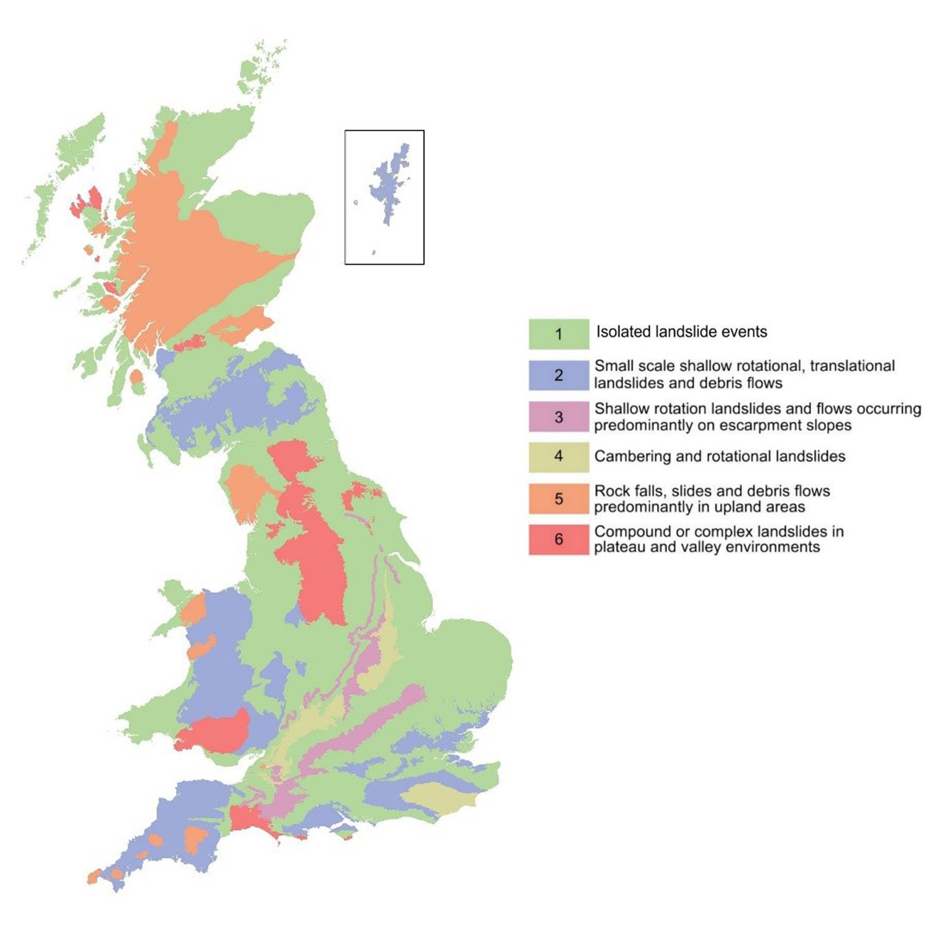

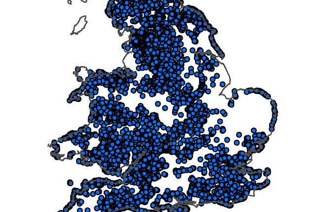
Top level landslide domains for Great Britain. BGS © UKRI.
The landslide domain map drew on a wide range of national-scale information held at the BGS and used the interrelations between materials and processes to produce boundaries that reflect areas of geomorphological and geological similarity. We have successfully used this style of mapping to create maps of Quaternary (Booth et al., 2012), till (Entwisle and Wildman, 2010) and hydrogeological domains in a framework of 3D geological models (McMillan et al., 2000).
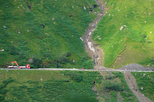
Debris flow-style landslide. BGS © UKRI.
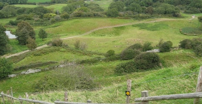
Relict rotational-style landslide. BGS © UKRI.
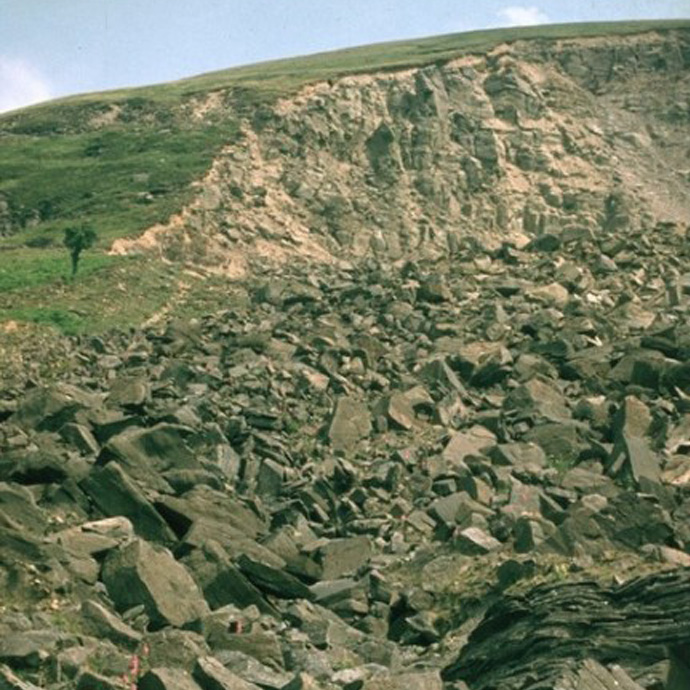
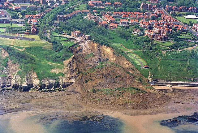
Large-scale rockfall. BGS © UKRI.
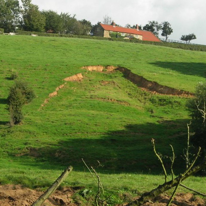
Small-scale, shallow landslide in soil. BGS © UKRI.
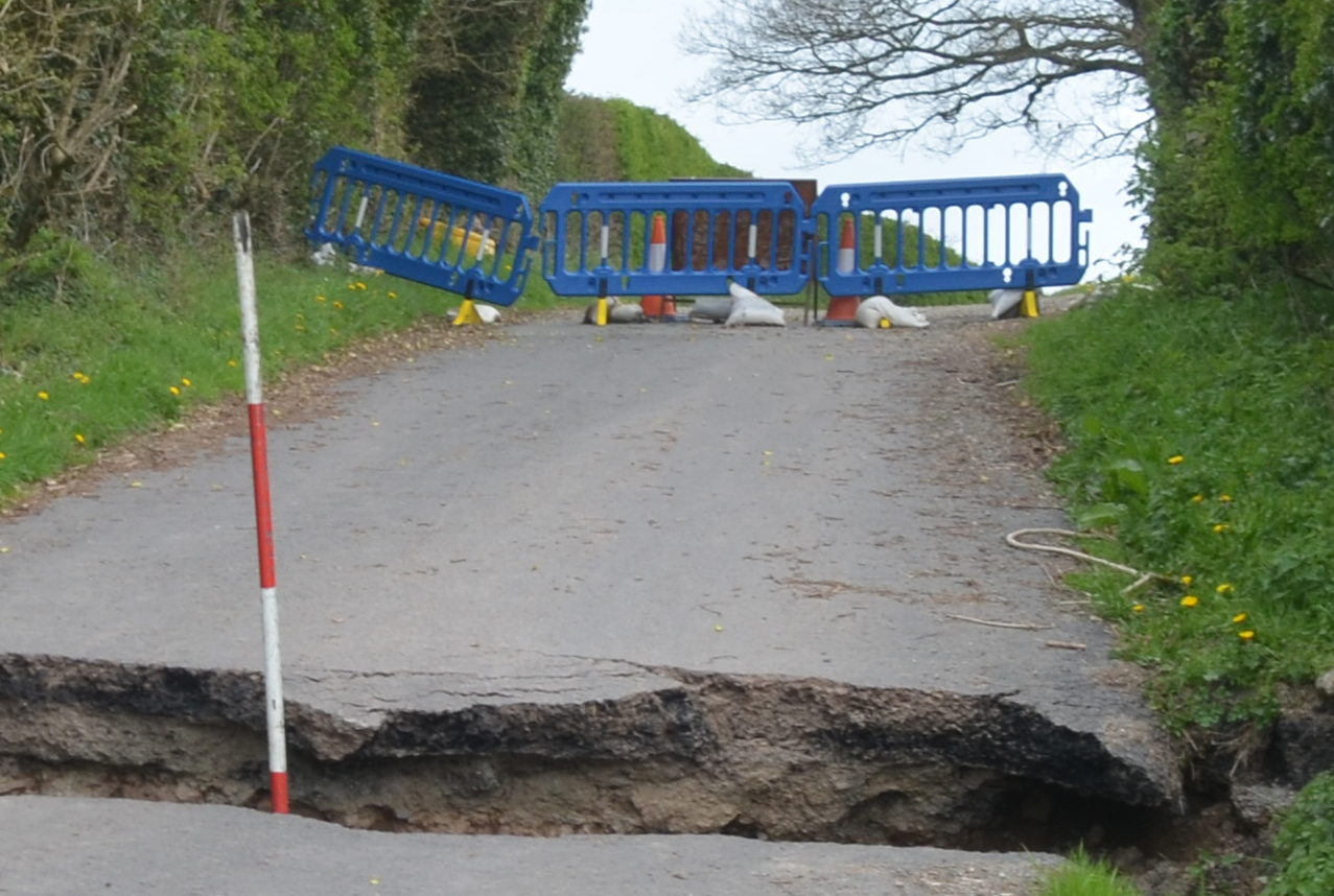
We continuously capture landslide data for the National Landslide Database (NLD) and the domain map is a way to allow the different scales of data collection to be integrated. Many of the landslides recorded in the NLD are ancient and inactive, but periods of high rainfall have resulted in an increase in landslide activity; with recent examples include the summer of 2012 and the winters of 2012–13, 2013–14 and 2015–16. Many of the landslides triggered during these periods were relatively small, but their impacts have been significant (e.g. causing fatalities in Burton Bradstock and Beaminster in 2012 and in Looe in 2013). These events have reinforced the importance of recording detailed information enabling further development of national-scale landslide susceptibility assessments alongside an understanding of the associated impacts of these landslides.
The landslide domain map, with its subdivision of the country into landslide-specific units, will aid the production of susceptibility maps on a more regionally specific basis, considering the different geological formations and the processes that drive landsliding whilst allowing the production of process-specific susceptibility maps.
Despite continued data collection and targeted regional mapping campaigns, there are still large areas of Great Britain where landslide events have not yet been recorded. Another goal of the landslide domains map is to provide a means to ‘fill in the gaps’ by applying knowledge gained from areas of similar topography and geological conditions without having to rely solely on extensive field work or remote sensing across a whole region.
A further driver for the production of a landslide domain map is the work we carry out to model rainfall-induced landslides. This work feeds into the landslide component of the Daily Hazard Assessment (DHA), which outlines the potential for landslides over the next 24-hour period. The domain map is a way of highlighting which areas are most susceptible to rainfall induced landslides and subsequently what the impact of these events will be.
Sources of information used to create the landslide domain map
| Data source | Description | Available scales |
|---|---|---|
| Geological maps | Bedrock geology, superficial deposits, artificial ground, linear features such as faults and mass movement deposits (Smith, 2013). | 1:10 000
1:25 000 1:50 000 |
| Engineering Geology Map | The Engineering Geology Map of the UK reassesses each of the lithostratigraphical bedrock units and lithogenetic superficial deposits on dominant lithology and characterises them by geotechnical properties and engineering behaviour (Dobbs et al., 2012). | 1:1 000 000 |
| National Landslide Database | The most comprehensive source of information on landslides in Great Britain, currently holds records of over 17 000 landslide events (Foster et al., 2012; Pennington et al., 2015). | First-hand field observations to 1:50 000 |
| GeoSure | A national map of landslide susceptibility on inland, natural slopes. | 1: 50 000 |
| Quaternary domain map | A subdivision of Great Britain into glaciated and non-glaciated terrain, refined into eleven domains reflecting geomorphological features, assemblages of superficial deposits and surface processes. | 1:1 000 000 |
| Aerial photographs | Aerial photographic interpretation is currently carried out using SOCETSET™, a digital photogrammetry software package used to view orthorectified aerial photographs in stereo. | 25 cm |
| Ground-based photographs | Conventional photography, including the BGS’s image archive ImageBase, has been utilised for local detail where required. | Ground-based |
| Topography maps | Ordnance Survey topographical maps. | 1:1250 –
1:1 000 000 |
| DTM (NextMapTM) | NextMapTM images, a digital terrain model produced by Intermap from airborne interferometric synthetic aperture radar (InSAR), proved useful for delineating topographical areas as well as creating maps for slope angle and relief, which could be used to create terrain units. | 25 m |
| Expert local geological knowledge | Expert local geological knowledge from BGS field mappers (where available) to provide clarification of details of lithostratigraphical and structural features and their influence on slope stability. | First-hand field observation |
Booth, K A, Booth, S J, and Slater, C. 2012. BGS Geological Cross-Sections and Quaternary Domains: user guidance note. British Geological Survey Open Report OR/10/030. (Nottingham: British Geological Survey.)
Entwisle, D C, and Wildman, G. 2010. Creation of the Till Thematic Layer. British Geological Survey Internal Report IR/10/041. (Nottingham: British Geological Survey.)
Foster, C, Pennington, C V L, Culshaw, M G, and Lawrie, K. 2012. The National Landslide Database of Great Britain: development, evolution and applications. Environmental Earth Sciences, Vol. 663, 941–953.
Gibson, A D, Culshaw, M G, Dashwood, C, and Pennington, C V L. 2013. Landslide management in the UK — the problem of managing hazards in a ‘low risk’ environment. Landslides, Vol. 10, 599–610.
McMillan, A A, Heathcote, J A, Klinck, B A, Shepley, M G, Jackson, C P, and Degnan, P J. 2000. Hydrogeological characterisation of the onshore Quaternary sediments at Sellafield using the concept of domains. Quarterly Journal of Engineering Geology and Hydrogeology, Vol. 33, 301–323.
Pennington, C V L, and Harrison, A M. 2013. 2012 — landslide year? GeoScientist, 10–15.
Pennington, C V L, Dijkstra, T A, Lark, M, Dashwood, C, Harrison, A M, and Freeborough, K A. 2014. Antecedent precipitation as a potential proxy for landslide incidence in SW UK. 253–269 in Landslide Science for a Safer Geoenvironment 1. Sassa, K, Canuti, P, and Yin, Y (editors). (Switzerland: Springer International Publishing.)
Pennington, C V L, Freeborough, K A, Dashwood, C, Dijkstra, T A, and Lawrie, K. 2015. The National Landslide Database of Great Britain: acquisition, communication and the role of social media. Geomorphology Special Issue: Geohazard Databases: Concepts, Development, Applications, Vol. 249, 44–51.
You may also be interested in:
Shallow geohazards
Measuring, recording and analysing near-surface geological hazards including landslides, sinkholes and discontinuities.
National Landslide Database
The BGS National Landslide Database (NLD) is the most extensive source of information on landslides in Great Britain.
Landslides
Building resilience both in the UK and internationally to landslides and carrying out many aspects of landslide research.