The Natural Hazards Partnership (NHP), established in 2011 under the terms of a Memorandum of Understanding, is a consortium of 22 government departments and agencies, trading funds and public sector research establishments. The NHP builds on the interdisciplinary expertise of its partners to deliver better coordinated natural hazards science, research and advice to governments, civil contingency responders and other hazard-resilience groups across the UK.
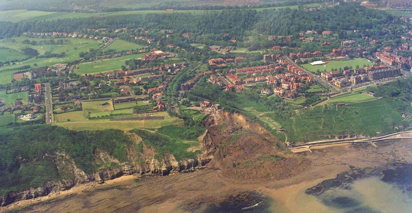

Holbeck Hall landslide. Source: BGS © UKRI
Primarily through the in-kind support of its partners and in response to consultation with UK governments and the responder community, the NHP has coordinated a range of natural hazard-related activities with particular highlights and achievements.
- NHP Daily Hazard Assessment, accessible through Met Office Hazard Manager and Cabinet Office Resilience Direct platforms
- Hazard Impact Framework, to support greater consistency of hazard impact assessments
- Prototype hazard impact models for four natural hazards
- Provision of expert advice, review and challenge of UK governments’ natural hazard risk assessment processes
Daily Hazard Assessment
The Daily Hazard Assessment (DHA) is an ‘at a glance’ overview of potential natural hazards and health implications that could affect the UK over the next five days. It provides a hazards summary to help increase the UK’s ability to respond to and be prepared for multi-hazard events.
Twenty-one natural hazards are included in the DHA. They are all assessed and the relevant ‘colour state’ is determined using a hazard matrix. A DHA contains links to more detailed information about each of the highlighted hazards, helping users to gain more value from existing services and thereby speeding up decision making and response.
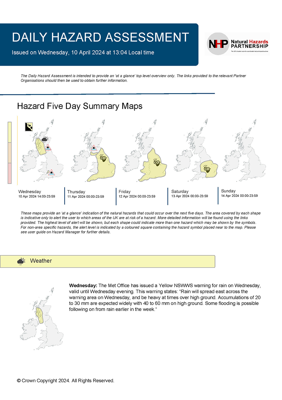
Daily hazard assessment. © Crown Copyright 2024.
Hazard Impact Framework
The Hazard Impact Framework (HIF) provides us with a common and consistent approach to modelling and forecasting natural hazard impacts. Specifically, the HIF is a source of definitions and common concepts in impact modelling. It provides standard guidelines and, where necessary, stricter protocols for developing hazard impact models.
Hazard Impact Models
Hazard impact models (HIMs) are designed to produce impact and risk information for individual natural hazards. Most HIMs are composed of three main elements: hazard, vulnerability and exposure. HIMs combine data and expertise from partners to identify areas and assets that are most vulnerable to a particular hazard. HIMs currently in development include
- landslides
- snow and ice
- surface-water flooding
- wind
National Risk Assessment
NHP plays a key role in UK risk assessment. It provides expertise and advice, coordinates its internal partners and delivers independent reviews regarding natural hazards for the UK’s National Risk Assessment (NRA) and National Security Risk Assessment (NSRA).
The Natural Hazards Partnership’s particular support to the NRA includes:
- identification of potential natural hazards for inclusion and assessment
- coordination of constituent organisations and agencies to support lead government departments in developing robust ‘reasonable worst-case scenarios’ for natural hazards
- provision of expertise to deliver an independent review function for natural hazard risks within the NRA
Geohazard notes
In response to the work of NHP, BGS has prepared a number of geohazard notes to provide relevant summary information for some of the geohazards that could affect the UK. The notes provide information on how and why a hazard occurs, how it is measured, locations susceptible to that hazard and possible worst-case scenarios.
The notes also give details on how BGS and collaborating organisations respond to such hazards.
NHP partners and collaborators
The NHP consists of public bodies — mainly government departments and agencies, trading funds and public-sector research establishments — including:
- British Red Cross
- Cabinet Office
- UK Centre for Ecology & Hydrology
- Department for Environment, Food & Rural Affairs
- Department for Transport
- England and Wales Wildfire Forum
- Environment Agency
- Government Office for Science
- Health and Safety Executive
- UK Health Security Agency
- Met Office
- National Centre for Atmospheric Science
- National Oceanography Centre
- Natural Environment Research Council
- Natural Resources Wales
- Network Rail
- Ordnance Survey
- Scottish Environment Protection Agency
- The Scottish Government
- UK Space Agency
- Welsh Government
You may also be interested in
Shallow geohazards
Measuring, recording and analysing near-surface geological hazards including landslides, sinkholes and discontinuities.

ARISTOTLE-ENHSP
The ARISTOTLE-ENHSP project delivers multi-hazard advice capability to the Emergency Response Coordination Centre (ERCC).