Groundwater provides water even during periods of lower than average rainfall and when surface water is in relatively short supply. This resilient resource can nevertheless become highly stressed if rainfall is reduced over a long period, resulting in a groundwater drought. We are working to better understand how groundwater droughts occur and the effects they have on humans and the environment.
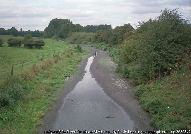

The River Ver near St Albans almost completely dried up in the summer of 1992 after a prolonged period of drought. The groundwater level in the underlying Chalk aquifer fell below the level of the river bed. © David Leeming.
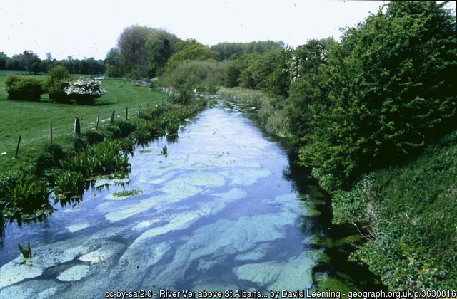
By May 1994 the River Ver had recovered to its normal levels after two wet winter seasons recharged the underlying aquifer. © David Leeming.
Groundwater droughts are marked by lower than average water levels in aquifers, borehole and wells, as well as by reduced flows to groundwater-fed rivers and wetlands. It is important to understand these relatively rare events to improve our planning for them and to help with water resource-management decisions during episodes of drought. A good understanding of the relationship between groundwater levels and rainfall during previous episodes of drought is critical for effective water-resource planning and drought management.
Groundwater droughts are relatively rare and few have been recorded based on direct observations of groundwater levels. However, rainfall records are typically much longer. By relating observed rainfall to observed, relatively short, groundwater-level records, we can use the longer rainfall records to ‘reconstruct’ much longer groundwater-level time series and hence ‘reconstruct’ older groundwater droughts.
Our hydrogeologists have undertaken such groundwater drought reconstructions for the Chalk Group of the UK and the whole of the UK; we are currently working on a similar reconstruction for groundwater levels across Europe.
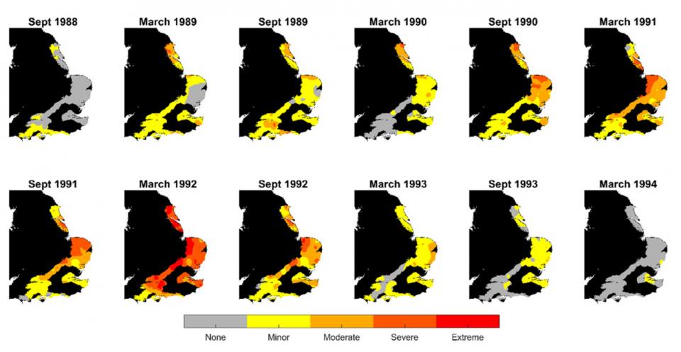
The Chalk is the most important aquifer in the UK and is prone to groundwater drought. Using a simple statistical model that relates rainfall to groundwater-level response and applying this to about 1000 observation boreholes across the Chalk aquifer, Marchant and Bloomfield (2018) reconstructed monthly groundwater levels from 1960 to 2015. They then standardised the groundwater-level time series using the standardised groundwater level index (SGI) of Bloomfield and Marchant (2013) to enable the investigation of the spatial and temporal evolution of individual episodes of groundwater droughts across the Chalk.
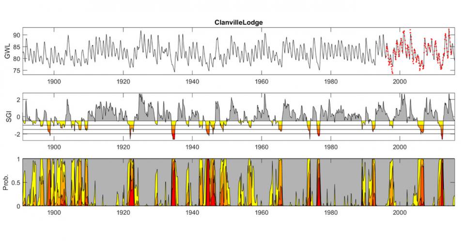
Our hydrogeologists have reconstructed groundwater levels at 54 observations boreholes across the UK from 1891–2015 using rainfall data provided by the Met Office. The sites are located on principal aquifers throughout the UK (Allen et al., 1997), although the majority of sites are in southern and eastern England and most on the Chalk aquifer. Groundwater levels were reconstructed using the BGS’s AquiMod model ,following the methods of Jackson et al. (2016).
In addition, standardised groundwater-level time series were estimated based on the reconstructed groundwater levels using the standardised groundwater-level index (SGI) of Bloomfield and Marchant (2013).
The SGI is an index that has been developed primarily for defining and monitoring groundwater drought for any location with historic data, enabling groundwater drought status to be directly compared with similar meteorological drought indices, such as the SPI (McKee et al., 1993), which is the primary tool for monitoring meteorological droughts as advocated by the World Meteorological Organization (2012).
The reconstructed groundwater-level data and corresponding SGI data are available through NERC’s Environmental Information and Data Centre (EIDC) (Bloomfield et al., 2018a; 2018b).
This work was part of the NERC-funded historical droughts project and the larger NERC-funded UK drought and water scarcity programme.
The European Groundwater Drought Initiative, or GDI, is a NERC-funded project to assess and model groundwater drought status across Europe; investigate the effects of groundwater drought, and to build a community to grow our understanding of the phenomenon of groundwater drought.
To enable the assessment of groundwater droughts across such a large and diverse area, it has been necessary to reconstruct groundwater levels in a consistent manner using an approach similar to that employed by Marchant and Bloomfield (2018) to reconstruct and standardise groundwater levels and identify groundwater droughts in the Chalk aquifer of the UK.
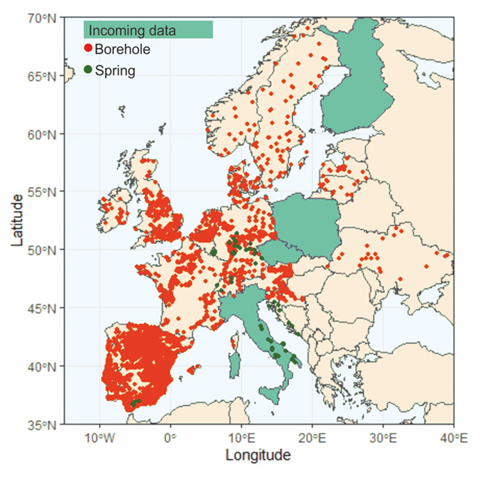
The standardised, reconstructed groundwater-level hydrographs are being analysed using techniques such as cluster analysis to identify both regionally consistent groundwater responses to droughts and responses that are typical of specific types of groundwater systems (Brauns et al., 2019). For example, some groundwater systems have very quick responses to rainfall anomalies (sometimes referred to as ‘flashy’ aquifers). These aquifers are prone to more groundwater droughts and recover more quickly at the end of a drought. Other aquifer systems respond much more slowly to rainfall anomalies and, although initially more resilient to major droughts, may be much slower to recover.
The analysis of the reconstructed time series is also enabling sites that have been influenced by long-term overabstraction of groundwater to be identified.
Allen, D J, Brewerton, L J, Coleby, L M, Gibbs, B R, Lewis, M A, MacDonald, A M, Wagstaff, S J, and Williams, A T. 1997. The physical properties of major aquifers in England and Wales. British Geological Survey Technical Report WD/97/34.
Bloomfield, J P, and Marchant, B P. 2013. Analysis of groundwater drought building on the standardised precipitation index approach. Hydrology and Earth System Sciences, Vol. 17(12), 4769–4787.
Bloomfield, J P, Marchant, B P, and Wang, L. 2018a. Historic standardised groundwater level index (SGI) for 54 UK boreholes (1891–2015). NERC Environmental Information Data Centre.
Bloomfield, J P, Marchant, B P, and Wang, L. 2018b. Historic reconstructions of monthly groundwater levels for 54 UK boreholes (1891–2015). NERC Environmental Information Data Centre.
Brauns, B, Bloomfield, J P, Cuba, D, Hannah, D M, Jackson, C R, Heudorfer, B, Marchant, B P, and Van Loon, A. 2019. The Groundwater Drought Initiative (GDI): analysis of European groundwater drought. [Lecture] In: 46th IAH Congress, Malaga, Spain, 22–27 September 2019. (British Geological Survey.)
Jackson, C R, Wang, L, Pachocka, M, Mackay, J D, Bloomfield, J P. 2016. Reconstruction of multi-decadal groundwater level time-series using a lumped conceptual model. Hydrological Processes, Vol. 30(18), 3107–3125.
Marchant, B P, and Bloomfield, J P. 2018. Spatio-temporal modelling of the status of groundwater droughts. Journal of Hydrology, Vol. 564, 397–413.
McKee, T B, Doesken, N J, and Kleist, J. 1993. The relationship of drought frequency and duration of time scales. Eighth Conference on Applied Climatology, January 17–23 1993, Anaheim, California, USA, 179–186. (American Meteorological Society.)
World Meteorological Organization. 2012. Standardized Precipitation Index User Guide. WMO-No. 1090. (Geneva.)
You may also be interested in:
Groundwater research
Addressing issues related to the sustainability of water resources and quality, and the effects of environmental change on the water cycle, natural hazards, and human health.

Emerging contaminants in groundwater
The term ’emerging contaminants’ is used to describe substances which are not yet regulated, but may be of environmental or human health concern.
Nitrate time bomb
Nitrate leaching from soils can have negative effects ecosystems and human health.