Improving the management of groundwater resources across Europe
Under the European Union’s Horizon 2020 ERA-Net cofunding scheme, BGS contributed to the action ‘Establishing the European geological surveys research area to deliver a geological service for Europe’, or GeoERA.
GeoERA consisted of four themes:
- geoenergy
- groundwater
- raw materials
- an information platform

GeoERA logo. © GeoERA.
The groundwater theme aimed to provide data, information and decision-support tools for the long-term protection, sustainable management and improvement of groundwater resources across Europe, within the framework of societal challenges and EU policies. The theme was made up of a number of research projects in which we had a leading role:
HOVER
The ‘Hydrological processes and geological settings over Europe’ (HOVER) investigated dissolved geogenic and anthropogenic elements in groundwater of relevance to human health and the status of dependent ecosystems.
The project aimed to understand the controls on groundwater quality across Europe using the combined expertise and data held by member states. BGS worked on nitrate and pesticide transport in groundwater and the presence of emerging organic compounds in groundwater.
RESOURCE
We contributed to two work packages in the ‘Resources of groundwater, harmonised at cross-border and pan-European scale’ (RESOURCE) research project.
CHAKA was a review of methods of characterising and classifying karst aquifers, with development and application of a karst classification method to diverse karst aquifers in Europe.
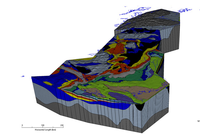
The pan-EU groundwater resources map used average depths and thicknesses of aquifers and aquitards to produce a map showing the depth and volume of fresh groundwater (including the position of the fresh/salt-water interface) and calculate Europe’s fresh groundwater balance.
TACTIC
The aim of the ‘Tools for assessment of climate change impact on groundwater and adaptation strategies’ (TACTIC) project was to better use data and knowledge acquired by European geological surveys in understanding the effects of climate change on groundwater systems. The project deliverable was a toolbox for assessing these effects and includes collected and processed data, visual information, mathematical tools and methodological protocols and guidelines.
VOGERA
Human activities in the subsurface pose a risk of introducing or releasing pollutants into shallow groundwater resources. The ‘Vulnerability of shallow groundwater resources to deep subsurface energy-related activities.’ (VOGERA) project aimed to improve scientific understanding of the vulnerability of shallow groundwater to deep subsurface, industrial energy-related activities, including:
- geothermal energy production
- unconventional oil and gas exploitation
- subsurface storage
- disposal of waste
The final goal was to develop an approach to evaluating groundwater vulnerability from subsurface activities that can be applied across Europe.
You may also be interested in
Groundwater research
Addressing issues related to the sustainability of water resources and quality, and the effects of environmental change on the water cycle, natural hazards, and human health.
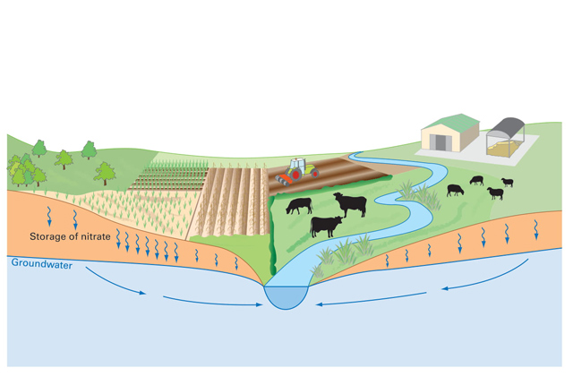
Nitrate time bomb
Nitrate leaching from soils can have negative effects ecosystems and human health.
Hydro-JULES
The Hydro-JULES research programme will develop a new generation of terrestrial hydrological models to understand the terrestrial water cycle.
Groundwater modelling
Our modelling research focuses on the development and application of models to improve our understanding of hydrological and groundwater processes