BGS was involved in Technical Co-operation projects in Sumatra with the Indonesian Ministry of Mines and Energy since 1975. This work has been supported with funding from the UK Department for International Development (DFID) (formerly Overseas Development Administration (ODA)). The objectives of this work were to assist Indonesia in its development by contributing to the regional geological, geochemical and geophysical mapping of Sumatra. The work was principally aimed at encouraging mining company activity to develop mineral resources in Sumatra. A major component of the co-operation was the training of Indonesian counterparts and encouraging institution-building processes.
There have been three major projects involving teams of resident BGS geoscientists based in the Geological Directorates in Bandung:
North Sumatra Project (NSP) 1975 – 1980
This project made regional geological maps and geochemical maps(based on stream sediments) at 1:250 000 scale for Sumatra north of the Equator. Each 1:250 k geological map is accompanied by a report and these are available for purchase from the GRDC library (at Jalan Diponegoro 57, Bandung). The 1:250 k quadrangle single element classified symbol geochemical maps are available (as an incomplete series) from the DMR library in Jalan Soekarno-Hatta 444. Most field maps and reports, sample powders, etc. are available in DMR by contacting the Head of the Geochemical and Minerals Information Sub-directorate in Bandung.
Northern Sumatra Geochemical and Mineral Exploration Project (NSGMEP) 1984 – 1988
The data generated by the North Sumatra Project was used as a basis for mineral exploration follow-up work in Sumatra north of the equator. A major objective in the work was the training of counterparts in methods of metalliferous mineral exploration and geochemical, geological and geochemical techniques were used. All mineral targets investigated are described in the NSGMEP report series which is available for inspection and copying at DMR Bandung (Geochemistry and Minerals Information Sub-directorate, Exploration Geochemistry Section retain the original maps and reports).
Southern Sumatra Geological and Mineral Exploration Project (SSGMEP) 1988 – 1994
This project was concerned with regional geological, geochemical and geophysical mapping of Sumatra south of the equator. This work commenced in the early 80’s and was helped to a successful conclusion with assistance from a team of BGS geoscientists. The geological work saw the completion of the 1:250 000 scale geological maps and reports. The regional geochemistry completed the regional geochemical mapping of Sumatra by stream sediment survey and the geophysicists compiled 1:250 000 Bouguer anomaly maps for some southern Sumatra quadrangles. Products are available for purchase as described for the North Sumatra Project, the geophysics maps also being available from GRDC.
The project’s geochemical, mineral occurrence and bibliographic databases were made available on the Sumatra CD-ROM database (versions 1.0 – 1.5). This CD-ROM is essentially an update of the geochemical databases that have been formatted to a consistent standard for both north and south of the equator. Grid references from the numerous UTM zones have been converted to longitude and latitude and a single database for the whole island of Sumatra is now available on this CD-ROM. This file is SUM98.XLS and can be found in the GEOCHEM directory. A coastline of Sumatra and the geochemical database are also included in MapInfo format.
Available digital text files from the SSGMEP are also included in the Reports directory. These were generally created in WordStar format and most have been converted to Word v 6.0 format. Report figures and maps not produced digitally are not included and should be obtained from the DMR office in Bandung.
The two most relevant references to the geochemical surveys in Sumatra are the atlases produced for north and south of the Equator are:
Stephenson B, Ghazali S A and Hariwidjaja (1982). Geochemical Atlas of Northern Sumatra. Regional Geochemical Atlas Series of Indonesia No. 1. Directorate of Mineral Resources, Bandung, Indonesia and British Geological Survey, Keyworth, United Kingdom.
Machali Muchsin, A, Johnson, C C, Crow, M J, Djumsari, A and Sumartono. 1997. Geochemical Atlas of Southern Sumatra. Regional Geochemical Atlas Series of Indonesia No. 2. Directorate of Mineral Resources, Bandung, Indonesia and British Geological Survey, Keyworth, United Kingdom.
During preparation of the CD-ROM the data has also been “cleaned” by replacing all 0 (below detection values) with a value 2/3rds the reported detection limits (rounded to an integer) i.e.
| Cu | 2 | 1 |
| Pb | 5 | 3 |
| Zn | 5 | 3 |
| Co | 2 | 1 |
| Ni | 5 | 3 |
| Mn | 50 | 30 |
| Ag | 1.0 | 0.7 |
| Li | 1 | 0.7 |
| K | 100 | 70 |
| Cr | 5 | 3 |
| Fe | 0.1% | 0.07 |
| As | 1.0 | 0.7 |
| Mo | 0.5 | 0.3 |
| Sn | 10 | 7 |
| W | 2.5 | 1.7 |
Absent data in the database is represented by null values.
Each quadrangle database contains UTM grid co-ordinates based on the Bessel 1841 map datum. The southern Sumatra data covers two UTM zones, namely UTM zone 47 (Padang, Solok, Painan and Sungaipenuh) UTM zone 48 (remaining Southern Sumatra quadrangles). The northern Sumatra data comes from three UTM zones: zone 46 (part of Banda Aceh and Calang; zone 48 (Siak Sri Indrapura); and zone 47 (remaining quadrangles).
All the quadrangle databases from the island of Sumatra have been combined to give a single database using longitude/latitude grid co-ordinates (file SUM98.XLS). The process of combining data from different zones and the different data sets of N and S Sumatra is outlined below. The S Sumatra co-ordinates are generally considered to be more accurate and are based on the 1:250 000 AMS topographic maps. Hardcopy drainage basemaps for the S Sumatra data are available from DMR in Bandung as the single element proportional symbol maps at 1:250 000 scale. The N Sumatra data is not so accurate and originates from old Dutch topographic maps. However, drainage bases on which these locations are based are available from DMR as hardcopy, 1:250 000 scale maps.
The combined database on the CD-ROM for southern Sumatra (SSUM95.XLS) presents all the data on the basis of UTM zone 48 co-ordinates. This is really a non-linear correction but on a regional scale near the equator it is acceptable to make a correction by subtracting 667 652 from the EASTING field in the UTM zone 47.
In order to create a single database for N Sumatra the UTM 47 co-ordinates are used as most of the data is from this zone. To achieve this, subtract 665 091 from the Eastings x 10 of UTM 46 and add 667 854 to the Easting x 10 values of UTM 48. The Easting is multiplied by a factor of 10 so as to bring the co-ordinates to be 1 grid unit equivalent to 1 m and consistent with the Southern Sumatra databases.
In order to combine the N and S Sumatra data a correction also has to be made to the Northing. The equator is UTM Northing 0 for data from the northern hemisphere but UTM Northing 10 000 000 for data from the southern hemisphere. Therefore the 10 m has to be added or subtracted according to which hemisphere you are standardising on.
(i) Analytical Methods Used
| Cu,Pb,Zn,Co,Ni,Mn,Ag | Hot nitric acid | AAS |
| Li,K,Cr,Fe | Hot perchloric/hydrofluoric acid | AAS |
| As,Mo | Potassium pyrosulphate/HCl | Colorimetric |
| Sn | Ammonium iodide/HCl | Colorimetric |
| W | Sodium bisulphate | Colorimetric |
A summary of the analytical methods used in the analysis of the stream sediment samples (summarised from Davis and Hartati, 1991a).
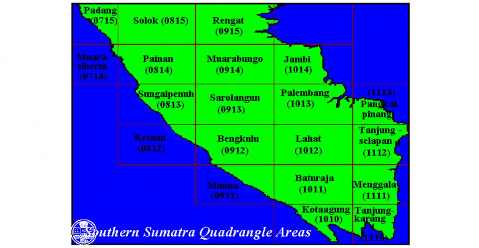
(ii) Quadrangle Areas
Southern Sumatra Quadrangle Areas
| Quadrangle | Area (km²) | Area Sampled (km²) | Number of Samples | Sampling density (no.per km²) | Adjusted sampling density (no.per km²) |
| Padang (0715) | 8,540 | 6,444 | 362 | 23.6 | 17.8 |
| Solok (0815) | 18,453 | 17,253 | 1,825 | 10.1 | 9.5 |
| Rengat (0915) | 17,465 | 4,326 | 309 | 56.5 | 14.0 |
| Painan&M.Siberut (0714 & 0814) | 17,650 | 15,171 | 1,869 | 9.4 | 8.1 |
| Muarabungo&Jambi (0914 & 1014) | 19,735 | 16,689 | 912 | 21.6 | 18.3 |
| S.Penuh&Ketaun (0813 & 0812) | 11,316 | 8,182 | 1,049 | 10.8 | 7.8 |
| Sarolangun (0913) | 18,460 | 14,962 | 1,268 | 14.6 | 11.8 |
| Palembang (1013) | 10,739 | 4,980 | 283 | 37.9 | 17.6 |
| Bengkulu (0912) | 17,645 | 15,946 | 1,139 | 15.5 | 14.0 |
| Lahat (1012) | 11,420 | 11,012 | 874 | 13.1 | 12.6 |
| Manna (0911) | 6,522 | 4,488 | 362 | 18.0 | 12.4 |
| Baturaja (1011) | 18,319 | 18,134 | 1,259 | 14,5 | 14.4 |
| Kotaagung (1010) | 9,315 | 8,725 | 726 | 12.8 | 12.0 |
| Menggala&T’karang (1111 & 1110) | 17,717 | 12,157 | 950 | 18.6 | 12.8 |
| Total | 203,296 | 158,469 | 13,187 | 15.4 | 12.0 |
A table summarising the sampling densities for the different quadrangle areas of Southern Sumatra. Padang, Solok, M.Siberut & Painan and S. Penuh & Ketaun are UTM Zone 47. The remaining quadrangles are from UTM Zone 48.
Northern Sumatra Quadrangle Areas
| Quadrangle Name | dbf Computer filename | Number of samples |
| BANDA ACEH (A) | QUADA46.DBF | 510 |
| BANDA ACEH (A) | QUADA47.DBF | 74 |
| LHOKSEUMAWE (B) | QUADB.DBF | 226 |
| CALANG (C) | QUADC.DBF | 256 |
| MEULABOH/TAKENGON(D) | QUADD.DBF | 1530 |
| LANGSA (E) | QUADE.DBF | 480 |
| TAPAKTUAN (F) | QUADF.DBF | 326 |
| MEDAN (G) | QUADG.DBF | 1156 |
| T.TINGGI (H) | QUADH.DBF | 170 |
| SIDIKALAN (K) | QUADK.DBF | 633 |
| PEMATANGSIANTAR (L) | QUADL.DBF | 684 |
| SIBOLGA (N) | QUADN.DBF | 133 |
| PADANGSIDEMPUAN (P) | QUADP.DBF | 916 |
| KOTATENGAH/DUMAI(Q) | QUADQ.DBF | 48 |
| NATAL (T) | QUADT.DBF | 1334 |
| PAKANBARU (U) | QUADU.DBF | 433 |
| SIAK SRI INDRAPURA(V) | QUADV.DBF | 85 |
Quada46.dbf and Quadc.dbf data are from UTM zone 46 and Quadv.dbf is from UTM zone 48. The rest of the data comes from UTM zone 47.
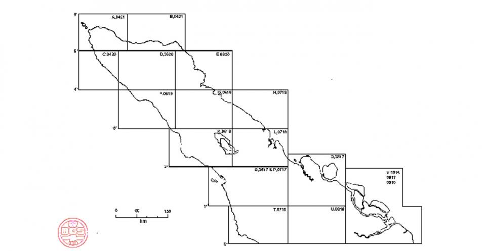
- Key to Quadrangle Codes used by North Sumatra Project (NSP)
| NSP Code | BAKOSURTANOL Code | Quadrangle Name |
| A | 0421 | Banda Aceh |
| B | 0521 | Lhoksaumawe |
| C | 0420 | Calang(Lhokreuet) |
| D | 0520 | Takengon(Meulaboh) |
| E | 0620 | Langsa |
| F | 0519 | Tapaktuan |
| G | 0619 | Medan |
| H | 0719 | Tebingtinggi |
| K | 0618 | Sidikalang (Pangururan) |
| L | 0718 | Pematangsiantar (Tanjungbalai) |
| O&P | 0617 & 0717 | Sibolga & Padangsidempuan |
| Q | 0817 | Dumai (inc. Bagansiapi-api) |
| T | 0716 | Lubuksikaping (Natal) |
| U | 0816 | Pakanbaru |
| V | 0916, 0917 & 1016 | Siak Sri Indrapura (inc.Bengkalis & Tanjungpinang) |
Summary of Southern Sumatra Regional Geochemical Mapping Project
| Area Name: | Southern Sumatra |
| Land Area: | 203,296 km² |
| Date of Sampling: | 1980 -1992 |
| UTM Grid Zones: | 47M and 48M |
| Corner co-ordinates: | |
| Minimum Longitude | 99°E |
| Maximum Longitude | 106°30’E |
| Minimum Latitude | 6°S |
| Maximum Latitude | 0° (Equator) |
| Drainage Basemap used: | Edited 1:250,000 JANTOP TNI(1974) Topographic Maps |
| Sample Type: | Stream sediment |
| Number of samples collected: | 13,187 |
| Sampling density: | 1 sample per 15.4 km² |
| Adjusted sampling density (not incl.swamp, towns, etc): | 1 sample per 12.0 km² |
| Sample fraction analysed: | -80# |
| Chemical analyses: | Directorate of Mineral Resources Laboratories, Bandung, Indonesia |
| Elements determined: | Cu, Pb, Zn, Co, Ni, Mn, Ag, Li, K, Cr, Fe, As, Sn, Mo , W. |
Reference to the CD-ROM should be as follows:
BGS (2007). Indonesia Regional Geochemical Survey CD-ROM: Sumatra. Version 3.0. BGS International Regional Geochemistry CD-ROM Series, No.1 Indonesia. British Geological Survey, Keyworth, Nottingham, UK
BGS Work in Indonesia
Central Enquiries
British Geological Survey
Keyworth, Nottingham NG12 5GG
United Kingdom
Tel: +44 (0)1159 363 143
Fax: +44 (0)1159 363 276
Email: enquiries@bgs.ac.uk
Collaborating organisation: Directorate of Mineral Resources, Bandung
Directorate of Mineral Resources Inventory (DMRI)
Jalan Soekarno-Hatta 444
Bandung 40254
Indonesia
Tel: +62 (0)22-5205572
Fax: +62 (0)22-5206263
Collaborating organisation: Geological Research and Development Centre, Bandung
Center for Geological Survey (CGS)
(Pusat Survei Geologi)
Geological Agency
Jalan Diponegoro 57
Bandung 40122
Indonesia
Tel. +62(0)22-7272601/7203205
Fax +62(0)22-7202669
| …\content\*.* (INFORMATION FILES)
Filename Date Time Size(bytes) Description
…\Content\Geochemistry Data\*.* (Excel file containing all Sumatra digital geochemical data) Filename Date Time Size(bytes) Description
…\Content\Geochemistry Data\NSUMATRA\*.* (dbf files containing N Sumatra quadrangle data plus Excel file containing all N Sumatra data) Filename Date Time Size(bytes) Description
…\Content\Geochemistry Data\SSUMATRA\*.* \ (dbf files containing S Sumatra quadrangle data plus Excel file containing all S Sumatra data) Filename Date Time Size(bytes) Description
…\Content\Geochemistry Data\MAPINFO\*.* (old project MapInfo files) Filename Date Time Size(bytes) Description
…\content\extras\minocc\*.* (Mineral occurrence data for S Sumatra) Filename Date Time Size(bytes) Description
…\content\extras\misc\*.* (Miscellaneous project files) Filename Date Time Size(bytes) Description 5
…\Content\Extras\REPORTS\*.* (List of reports produced by project) Filename Date Time Size(bytes) Description
…\Content\Extras\REPORTS\GEOCHEM\ (surviving digital files from S Sumatra quadrangle Geochemistry reports) …\Content\Extras\REPORTS\GEOCHEM\LAHAT\ …\Content\Extras\REPORTS\GEOCHEM\MANNA\ …\Content\Extras\REPORTS\GEOCHEM\MBUNGO\ …\Content\Extras\REPORTS\GEOCHEM\PADANG\ …\Content\Extras\REPORTS\GEOCHEM\PAINAN\ …\Content\Extras\REPORTS\GEOCHEM\PALEMBAN\ …\Content\Extras\REPORTS\GEOCHEM\SAROLANG\ …\Content\Extras\REPORTS\GEOCHEM\SPENUH\ …\Content\Extras\REPORTS\MINOCCS\ (Simplified Geology and Mineral Occurrence reports for S Sumatra Quadrangles) …\Content\Extras\REPORTS\SEMINAR\ (Papers from the end of project seminar) Surviving digital files from the SSGMEP report series …\Content\Extras\REPORTS\SSGMEP01\ …\Content\Extras\REPORTS\SSGMEP02\ …\Content\Extras\REPORTS\SSGMEP03\ …\Content\Extras\REPORTS\SSGMEP04\ …\Content\Extras\REPORTS\SSGMEP05\ 6 …\Content\Extras\REPORTS\SSGMEP07\ …\Content\Extras\REPORTS\SSGMEP08\ …\Content\Extras\REPORTS\SSGMEP09\ …\Content\Extras\REPORTS\SSGMEP10\ …\Content\Extras\REPORTS\SSGMEP11\ …\Content\Extras\REPORTS\SSGMEP12\ …\Content\Extras\REPORTS\SSGMEP13\ …\Content\Extras\REPORTS\SSGMEP14\ |
Purchase information
You may also be interested in:
International geochemistry CD-ROM series
Regional geochemical data from a range of overseas countries are available on a series of CD-ROMS.

Applied geochemistry
Since the 1960s, the BGS has amassed considerable geochemical data holdings and developed significant expertise in applied geochemistry.