Earthquakes happen when there is a sudden movement of the rocks along a fault inside the Earth. As the rocks on either side of the fault move past each other, they send seismic waves through the Earth, radiating outwards like the ripples produced when a stone is dropped into a pond.
Earthquake detection
A seismogram is a record of the ground motions caused by seismic waves from an earthquake. A seismograph or seismometer is the measuring instrument that creates the seismogram. Almost all seismometers are based on the principle of inertia, that is, where a suspended mass tends to remain still when the ground moves.
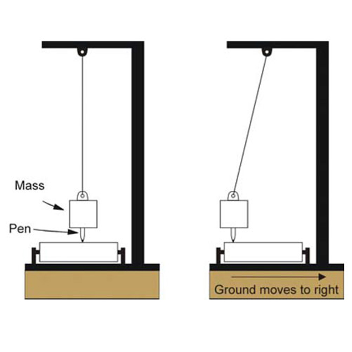

An illustration of a simple seismometer. The suspended mass tends to stay still, due to its inertia, when the ground moves. The pen records the relative motion. BGS ©UKRI. All rights reserved.
Seismometers allow us to detect and measure earthquakes by converting vibrations due to seismic waves into electrical signals, which we can then display as seismograms on a computer screen. Seismologists study earthquakes and can use this data to determine where and how big a particular earthquake is.
To record the actual motion of the ground in all three dimensions, seismologists need to use three separate sensors within the same instrument. Each sensor records the vibrations in a different direction:
- the Z component measures up/down motion
- the E component measures east/west motion
- the N component measures north-south motion
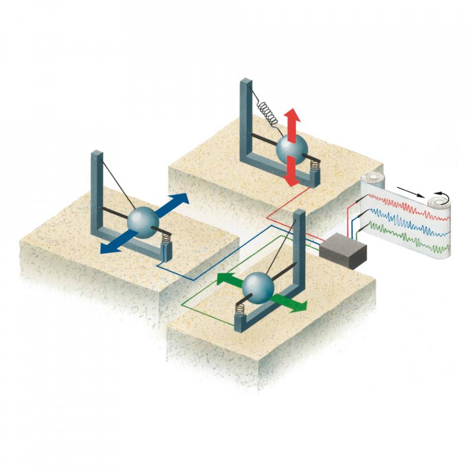
A three-component seismometer. Z (red) measures up/down motion; E (green) measures east/west motion; N (blue) measures north/south motion. BGS ©UKRI. All rights reserved.
Seismic waves
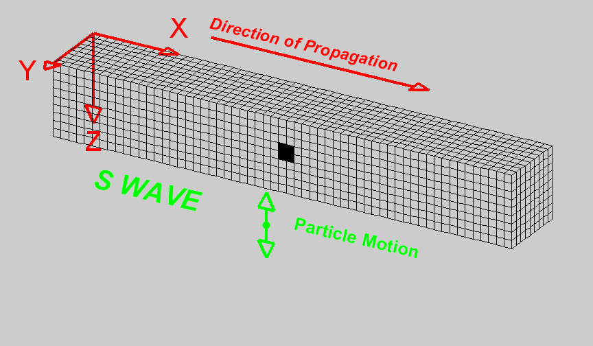
There are two basic types of seismic wave that travel through the body of the Earth: P-waves and S-waves. P-waves are longitudinal waves that consist of a series of compressions and dilations along the direction of travel. The P stands for primary because they travel the fastest. S-waves are transverse waves, whose motion is perpendicular to the direction of travel. The S stands for shear or secondary since they are slower than P-waves.
Where a free surface is present (like the Earth/air interface) these two types of motion can combine to form surface waves, which produce a type of shaking that causes buildings to fail and fall down. There are two types of surface waves: Rayleigh waves and Love waves. Rayleigh waves are generated by the interaction of P- and S-waves at the surface of the Earth, while Love waves are generated by interference of multiple shear waves. The ground motions from surface waves are often much larger than those motions from body waves.
| Type (and names) | Particle motion | Typical velocity | Other characteristics |
|---|---|---|---|
| P Compressional Primary Longitudinal | Alternating compressions (‘pushes’) and dilations (‘pulls’) in the same direction as the wave is propagating. | VP 5–7 km/s in typical Earth’s crust: >8 km/s in Earth’s mantle and core; 1.5 km/s in water; 0.3 km/s in air. | P motion travels fastest in materials, so the P-wave is the first energy to arrive on a seismogram. Generally smaller and higher frequency than the S and surface waves. P-waves in a liquid or gas are pressure waves, including sound waves. |
| S Shear Secondary Transverse | Alternating transverse motions perpendicular to the direction of propagation. | VS 3–4 km/s in typical Earth’s crust; 4.5 km/s in Earth’s mantle; 2.5–3.0 km/s in (solid) inner core. | S-waves do not travel through fluids, so do not exist in Earth’s liquid outer core or in air, water or molten rock (magma). S-waves travel slower than P-waves in a solid and, therefore, arrive after the P-wave. |
| L Love Surface waves | Transverse horizontal motion, perpendicular to the direction of propagation and generally parallel to the Earth’s surface. | VL 2.0–4.5 km/s in the Earth depending on frequency of the propagating wave. | Love waves exist because of the Earth’s surface. They are largest at the surface and decrease in amplitude with depth. Love waves are dispersive, that is, the wave velocity is dependent on frequency, with low frequencies normally propagating at higher velocity. Depth of penetration of the Love waves is also dependent on frequency, with lower frequencies penetrating to greater depth. |
| R
Rayleigh | Motion is both in the direction of propagation and perpendicular (in a vertical plane). | VR 2.0–4.5 km/s in the Earth depending on frequency of the propagating wave. | Rayleigh waves are also dispersive and the amplitudes generally decrease with depth in the Earth. Appearance and particle motion are similar to water waves. |
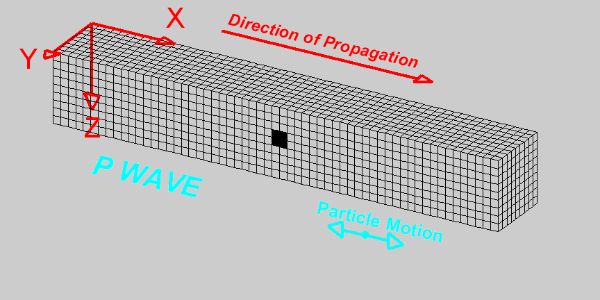 Note the deformation of the black rectangle as the wave propagates through it.
Animation and captions courtesy of L Braile, Purdue University www.ics.purdue.edu/~braile
Note the deformation of the black rectangle as the wave propagates through it.
Animation and captions courtesy of L Braile, Purdue University www.ics.purdue.edu/~braile
How are earthquakes located?
Earthquakes generate different types of seismic waves and these travel at different speeds through the Earth. P-waves are fastest and are the first signal to arrive on a seismogram, followed by the slower S-wave, then the surface waves. The arrival times of the P- and S-waves at different seismometers are used to determine the location of the earthquake. Assuming that we know the relative speed of P- and S-waves, the time difference between the arrivals of the P- and S-waves determines the distance the earthquake is from the seismometer.
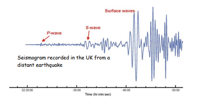
Seismogram showing the arrival time sequence of P-, S- and surface waves from a distant earthquake. ©UKRI. All rights reserved.
By looking at the seismograms from different recording stations, we can find out the epicentre of the earthquake. The signals arrive first at the closest station and last at the one furthest away. The time difference between the P- and S-waves tells us the distance the earthquake is from the seismometer. If we calculate the S minus P time to determine distance from the seismometer at three stations, we can work out where the epicentre of the earthquake is.
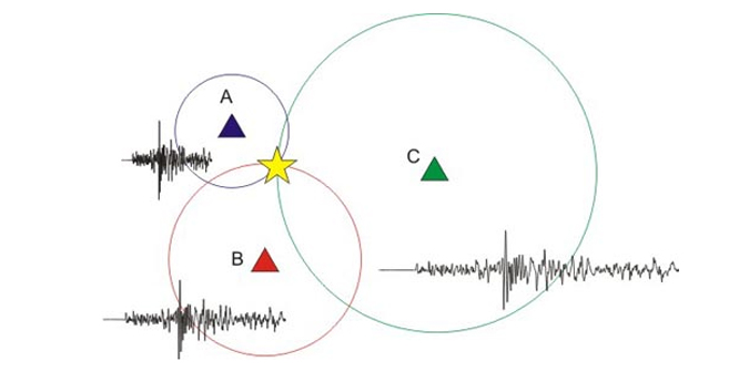
Imagine A, B and C are three different seismometer stations at distant locations. Once we know the distance to an earthquake from three seismic stations, we can determine the location of the earthquake. Draw a circle around each station with a radius equal to its distance from the earthquake. The earthquake occurred at the point where all three circles intersect. BGS ©UKRI. All rights reserved.
How are earthquakes measured?
Measurement of the severity of an earthquake can be expressed in several ways, but the two most common scales used by seismologists are intensity and magnitude.
Earthquake intensity
Intensity is a qualitative measure of the strength of shaking caused by an earthquake determined from the observed effects on people, objects and buildings. For a given earthquake, the intensity normally decreases with distance from the epicentre. There are a number of different intensity scales in use around the world that are all based on the shaking people experience and the effects it has on objects and buildings. It is also possible to estimate intensity from recordings of ground motions.
In the UK, we use the European Macroseismic scale (EMS) to quantify the effect of earthquake shaking on people, objects and buildings. Estimates of intensity from different locations can be combined to make macroseismic maps that show how the strength of shaking varies.
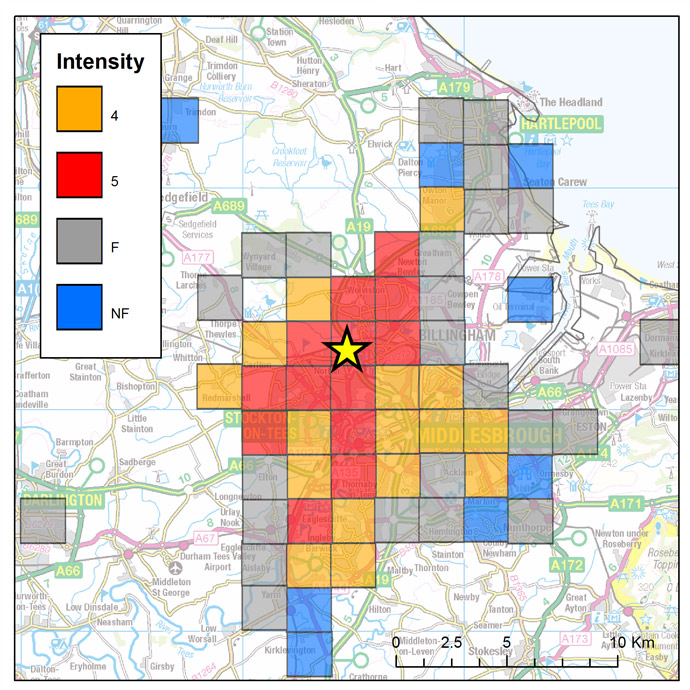
Macroseismic intensities (EMS) for the magnitude 3.1 ML earthquake on 23 January 2020, near Stockton-on-Tees, UK. The yellow star shows the earthquake epicentre. Intensities are calculated in 2 km grid squares from over 840 reports from people who felt the earthquake. A minimum of five observations are needed in any grid square to calculate a value of intensity, otherwise the value is recorded as ‘Felt’, but no intensity is calculated (shown by grey squares). Blue squares indicate that reports from these locations suggest that the earthquake was not felt. BGS © UKRI. All rights reserved.
Since earthquake intensity can be related to what people feel or experience during the shaking from an earthquake it is possible to use people as ‘intensity sensors’ and collect earthquake-felt reports for significant earthquakes. For example:
Scientists can make use of these felt-report surveys to compare the size of recent earthquakes to ones that occurred before modern scientific measurements (from about 1970 in the UK), but for which contemporary written reports are available. In this way earthquake records in the UK can be extrapolated back to the 14th century.
| EMS | Definition | Description |
|---|---|---|
| 1 | Not felt | Not felt, even under the most favourable circumstances. |
| 2 | Scarcely felt | Vibration is felt only by individual people at rest in houses, especially on upper floors of buildings. |
| 3 | Weak | The vibration is weak and is felt indoors by a few people. People at rest feel a swaying or light trembling. |
| 4 | Largely observed | The earthquake is felt indoors by many people, outdoors by very few. A few people are awakened. The level of vibration is not frightening. Windows, doors and dishes rattle. Hanging objects swing. |
| 5 | Strong | The earthquake is felt indoors by most, outdoors by few. Many sleeping people awake. A few run outdoors. Buildings tremble throughout. Hanging objects swing considerably. China and glasses clatter together. The vibration is strong. Top-heavy objects topple over. Doors and windows swing open or shut. |
| 6 | Slightly damaging | Felt by most indoors and by many outdoors. Many people in buildings are frightened and run outdoors. Small objects fall. Slight damage to many ordinary buildings, e.g. fine cracks in plaster and small pieces of plaster fall. |
| 7 | Damaging | Most people are frightened and run outdoors. Furniture is shifted and objects fall from shelves in large numbers. Many ordinary buildings suffer moderate damage: small cracks in walls; partial collapse of chimneys. |
| 8 | Heavily damaging | Furniture may be overturned. Many ordinary buildings suffer damage: chimneys fall; large cracks appear in walls and a few buildings may partially collapse. |
| 9 | Destructive | Monuments and columns fall or are twisted. Many ordinary buildings partially collapse and a few collapse completely. |
| 10 | Very destructive | Many ordinary buildings collapse. |
| 11 | Devastating | Most ordinary buildings collapse. |
| 12 | Completely devastating | Practically all structures above and below ground are heavily damaged or destroyed. |
Abstracted from Grünthal, G (editor), Musson, R, Schwarz, J, and Stucchi, M. 1998. European Macroseismic Scale 1998. Cahiers du Centre Européen de Géodynamique et de Séismologie Vol. 15. (Luxembourg: European Center for Geodynamics and Seismology.)
Earthquake magnitude
Magnitude is a measure of the amount of energy released during an earthquake and can be estimated from the amplitude of ground motions recorded by seismometers. It is independent of distance from the epicentre.
A number of different magnitude scales have been developed based on the amplitude of different parts of the observed record of ground motion with specific corrections for distance. Earthquake magnitude scales are logarithmic, i.e. a one unit increase in magnitude corresponds to a tenfold increase in amplitude.
The first magnitude scale was developed by Charles Richter in 1935 using observations of earthquakes in southern California and, although the scale is only strictly applicable there, it has been used all around the world. Press reporters love the Richter scale and will report any earthquake magnitude as a ‘magnitude on the Richter scale’. However, for any large earthquake that has made the news, it is very unlikely that a Richter (or local) magnitude is an appropriate scale.
Due to the complexities of the calculations, the reported magnitude of events can change as more data gets analysed. For the devastating 24 December 2004 event in Sumatra, the original magnitude of Mw 9.0 was recalculated several months later to Mw 9.3 as more data was analysed.

Fast fact
We can’t directly measure the size of an earthquake, because of all the complex and inaccessible geology that lies hidden beneath the surface of the Earth.
Seismologists have to use various methods to try and measure earthquakes by the effects they produce at the surface.
Moment magnitude
Nowadays, the most standard and reliable measure of earthquake size is moment magnitude (Mw), which is based on seismic ‘moment’. Moment is related to the area of the earthquake fault rupture and the amount of slip on the rupture, as well as the strength of the rocks themselves. Richter’s original magnitude scale underestimates the size of large events, so the constants used in the definition of Mw were chosen so that the magnitude numbers for Richter and moment magnitudes match for smaller events.
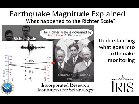

Moment magnitude explained — what happened to the Richter Scale? Source: www.iris.edu/educate
More about magnitude
Seismic moment (Mo) = μ × rupture area × slip length
where μ is the shear modulus of the crust (approximately 3 × 10¹⁰ N/m)
Moment magnitude (Mw) = 2/3(log Mo) – 6.06
Originally earthquake magnitudes were based on the amplitude of ground motion displacement as measured by a standard seismograph. The best known of these is the Richter magnitude, which was defined for local earthquakes in southern California.
ML = (log A) + 2.56(log D) – 1.67
Where A is the measured ground motion (in micrometres) and D is the distance from the event (in kilometres). This is still used for measuring the magnitude of shallow events at distances less than 600 km (today called the local magnitude or ML). For events larger than ML 8, this scale saturates and gives magnitude estimates that are too small.
For earthquakes measured at distances greater than 600 km, magnitude can be estimated from the formula:
Mb = log(A/T) + σ(D,h)
Where A is the maximum amplitude (in micrometres) of the P-waves measured at period T (generally about one second) and σ is a calibration term (in the range 6–8) that depends on distance from the event D and depth of the event h (tables of σ are used).
For shallow earthquakes (i.e. ones that generate surface waves) magnitudes can be estimated using the formula:
MS = log(A/T) + 1.66(log Δ) + 3.3
Where A is the maximum amplitude (in micrometres) of the Rayleigh waves, T is the period (usually about 20 seconds) and Δ is the distance (in degrees).
Seismic energy
Earthquake energy is a function of magnitude. Both the magnitude and the seismic moment are related to the amount of energy that is radiated by an earthquake.
| Magnitude | Energy in joules | Notes |
|---|---|---|
| -3.0 | 2 | 1 kg dropped 20 cm |
| -2.0 | 63 | |
| -1.0 | 2000 | 100 kg person jumps down 2 m |
| 0.0 | 6.3 × 10⁴ | |
| 1.0 | 2.0 × 10⁶ | |
| 2.0 | 6.3 × 10⁷ | Only felt nearby |
| 3.0 | 2.0 × 10⁹ | Energy from 50 litres of petrol |
| 4.0 | 6.3 × 10¹⁰ | Often felt up to tens of miles away |
| 5.0 | 2.0 × 10¹² | Energy from 50 000 litres of petrol |
| 6.0 | 6.3 × 10¹³ | 3.3 Hiroshima-sized A bombs |
| 7.0 | 2.0 × 10¹⁵ | |
| 8.0 | 6.3 × 10¹⁶ | 1–2 earthquakes this size each year |
| 9.0 | 2.0 × 10¹⁸ | Total annual energy use of UK |
You may also be interested in
Discovering Geology
Discovering Geology introduces a range of geoscience topics to school-age students and learners of all ages.
Earth hazards
The Earth beneath our feet is constantly shifting and moving, and violently with catastrophic and immediate results. Find out more about earth hazards.
Earthquakes
Earthquakes are among the most deadly natural hazards. They strike without warning and many earthquake zones coincide with areas of high population density.
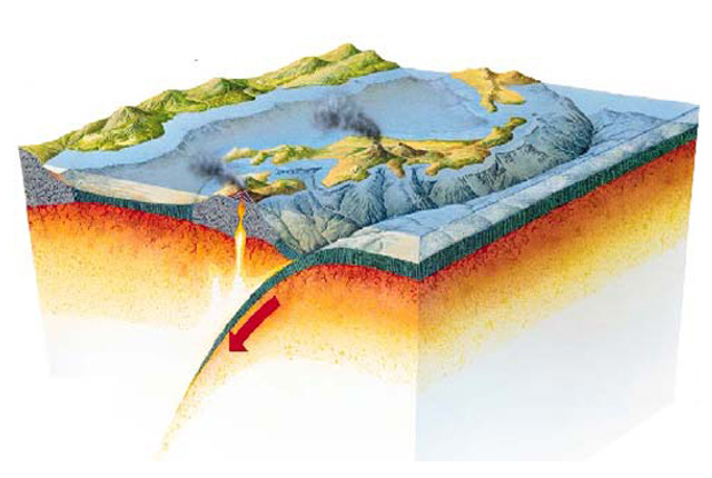
What causes earthquakes?
The causes of earthquakes and the different types of tectonic boundaries and faults on which they usually occur.
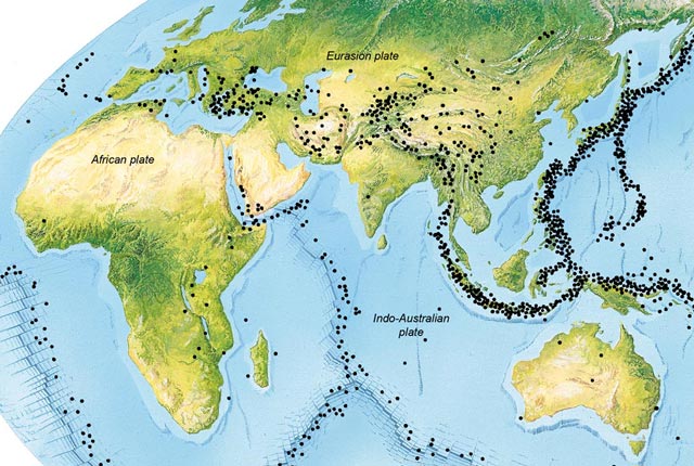
Where do earthquakes occur?
Where earthquakes occur around the world and in the UK.
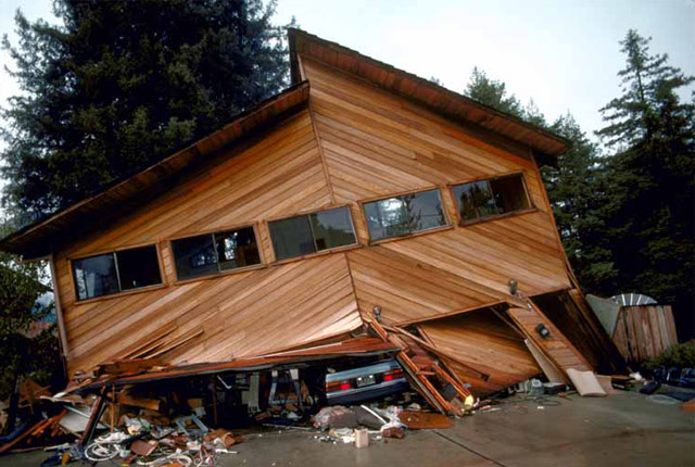
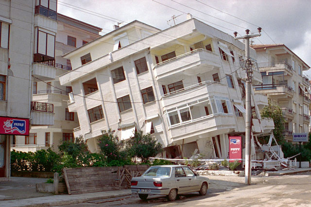
How do earthquakes affect people?
The extent of damage an earthquake causes depends not only on the magnitude of the earthquake, but also on local geology and on building techniques.