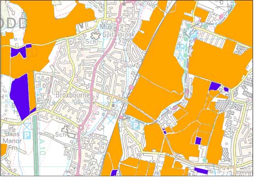

Historical Planning Permission Database example.
Historical planning permission database
- 1:50 000
- England and Wales
- Premium
This dataset contains hand-drawn boundaries showing mineral related planning permissions and land use collated from the 1940s to the mid 1980s.
Key information
- Scale:
- 1:50 000
- Coverage:
- England and Wales
- Availability:
- Premium
- Price:
£0.06 per km2. Available on request. Subject to number of users, licence fee and data preparation fee.
- Format:
- GIS polygon data (ESRI, others available by request)
- Uses:
- Local-level to regional-level use
- Themes:
- Built environment, Mining and minerals
The dataset holds information relating to planning permissions granted for mineral extraction and associated facilities and historic land use associated with permitted, withdrawn and refused mineral planning permission sites
The dataset has been derived from approximately 1400 1:25 000-scale paper maps and associated card index that was originally compiled by the Minerals Division of the Ministry of Housing and Local Government (MHLG). They contain hand-drawn boundaries showing mineral related planning permissions and land use collated from the 1940s (retrospectively to 1930) to the mid-1980s. The data contains supplementary information regarding name, operator, dates and relevant local planning authority.
As the data pertains to planning permissions from 1930 to the mid-1980s, it only represents a historic ‘snapshot’ in time. It does not show subsequent applications, resubmissions or later reworking, e.g. opencast reworking of waste tips. Details of these are held by Local Authority Mineral Planning Departments.
Historical planning permission database sample. BGS © UKRI – Contains OS data © Crown copyright 2020.
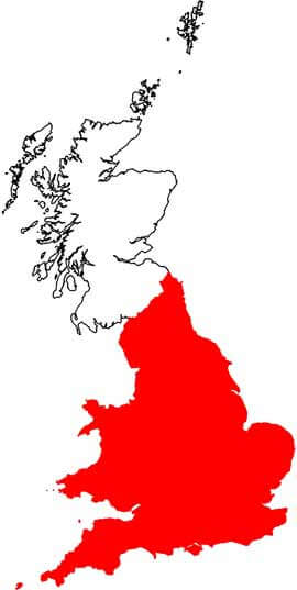
Coverage of the database. BGS © UKRI – Contains OS data © Crown copyright 2020.
You may also be interested in

Mineral resources
This dataset contains the geological distribution of all onshore mineral resources.
UK and world mineral statistics datasets
The British Geological Survey (BGS) has one of the largest databases in the world on the production and trade of minerals.