A new BGS platform to model volcanic ash in the atmosphere
BGS has supported the creation of a new modelling platform to aid research workflows around ash dispersion simulation.
16/12/2020 By BGS Press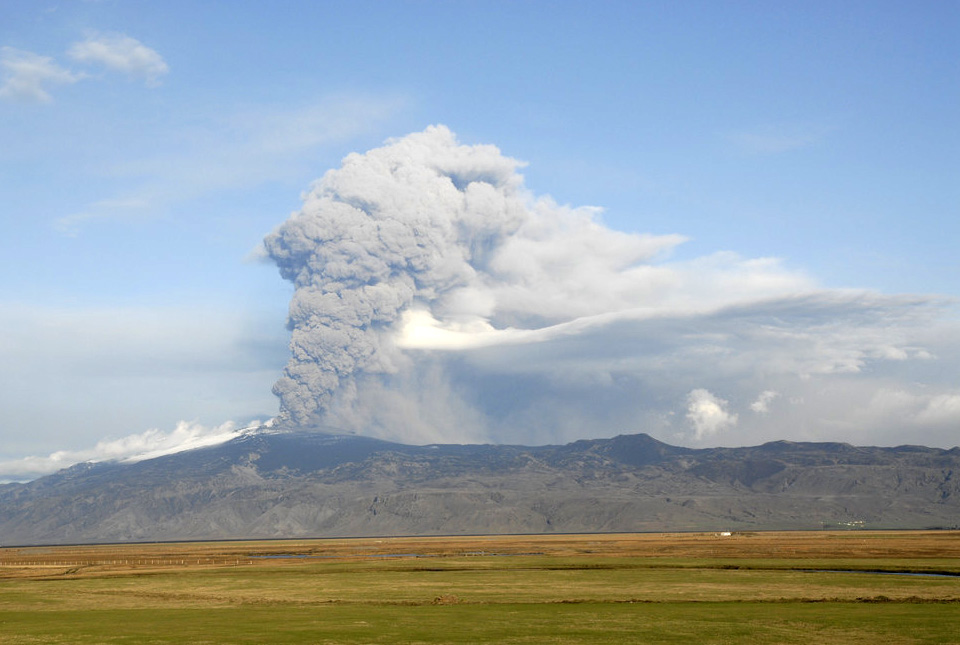

Fabio Dioguardi has been working as a volcanologist at BGS since 2015. His fundamental and applied research focuses on the physical processes and impacts of explosive volcanic eruptions by means of an integrated approach combining field data, experiments and modelling.
Volcanic tephra in the atmosphere and on the ground produced during explosive volcanic eruptions represents a threat to human health and infrastructure and possible serious disruption to various sectors of economy and business. For example, volcanic ash (tephra less than 2 mm in size) in the atmosphere can seriously damage aircrafts, leading to preventive measures like airspace closure in the event of an explosive volcanic eruption, similar to the 2010 eruption of Eyjafjallajökull in Iceland.
In order to mitigate the potential impact of these natural events, simulation tools to predict the advection and sedimentation of tephra in the atmosphere have been developed and are currently used by volcano observatories, Volcanic Ash Advisory Centres (VAAC) and researchers. The simulation of such complex phenomena is not an easy task, but it consists of two fundamental steps.
The first step is characterisation of the source, i.e. modelling of the volcanic plume by quantifying parameters like the source mass flux of emitted volcanic material (also known as mass eruption rate (MER)), the spatial evolution of the plume (e.g. top height; wind-blown trajectory), particle characteristics (grain size; density; shape), and duration of the eruption.
The second step involves simulation of the advection-diffusion-sedimentation of the emitted volcanic tephra cloud.
Both steps are coupled to numerical weather prediction model outputs, since weather conditions like temperature, humidity and wind influence both processes. For example, temperature and humidity influence the plume rise in the atmosphere, while wind can bend the plume and plays a major role in the near to far-field transport and sedimentation of volcanic ash.
The workflow leading to dispersion simulation outputs can be time-consuming and complicated, so BGS’s Innovation Flexible Fund supported the creation of a new modelling platform (BGS automatic ash dispersion modelling, or BGS-AADM) designed to simplify this workflow for both real-time and reanalysis (past eruption) applications.
This platform:
- automatically downloads and processes data of the NOAA-GFS numerical weather prediction model
- characterises the source conditions, particularly the top plume height and mass eruption rate, using both the BGS-USGS eruption source parameters database and REFIR, a semi-automatic tool for the quantification of top plume height and mass eruption rate (and associated uncertainty) based on observational data
We have used REFIR in collaboration with the Istituto Nazionale di Geofisica e Vulcanologia (INGV, Italy) to quantify these source parameters on selected test past eruptions of Mount Etna in the framework of the Horizon 2020 EUROVOLC project activities (Figure 1).
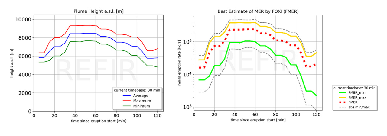
Figure 1 Plume height (PH) and mass eruption rate (MER) assessed by REFIR for the 12 January 2011 plume from Mount Etna. Left: PH time series (red line: maximum; blue line: average; green line: minimum). Right: MER time series (solid yellow line: maximum; dotted red line: best estimate; solid green line: minimum). BGS © UKRI.
The platform also:
- runs dispersion simulations with two dispersion models, HYSPLIT and FALL3D
- automatically produces contour plots of the dispersion simulations results with a new Python package (Ash Model Plotting) developed at BGS in the framework of the Innovation Flexible Fund project
Graphical outputs include maps of total column mass loading in the atmosphere, i.e. the total mass of tephra integrated from the ground to the top of the volcanic cloud, tephra concentration at various altitudes and total tephra deposit (mass loading) on the ground (Figure 2).
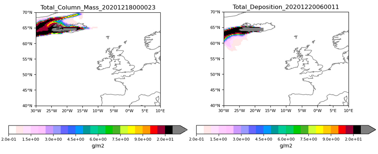
Figure 2 An example of graphical outputs obtained for an eruption scenario at Grímsvötn (Iceland). The plot on the left shows the total mass of volcanic particles present in the atmosphere from the sea level to the top of the ash cloud. The plot on the right shows the total mass of volcanic particles deposited on the ground from the beginning to the end of the simulated eruption. BGS © UKRI.
BGS-AADM is designed for both research applications on explosive volcanic eruptions producing ash clouds (e.g., the analysis of past events) and real-time applications during volcanic unrest and eruptions. In particular, it will be used as a further source of information to support BGS response during a future volcanic eruption in Iceland, in particular for better assessing the uncertainty of eruption source parameters and dispersion model outputs.
Jenkins, S. F., Wilson, T. M., Magill, C. R., Stewart, C., Blong, R. J., Marzocchi, W., et al. (2015). Volcanic ash fall hazard and risk. In S. C. Loughlin, R. S. J. Sparks, S. K. Brown, S. F. Jenkins, & C. Vye‐Brown (Eds.), Global Volcanic Hazards and Risk (pp. 173–221). Cambridge, UK: Cambridge University Press. https://doi.org/10.1017/CBO9781316276273.00
Dioguardi, F., Beckett, F., Dürig, T., Stevenson, J. A. (2020) “The impact of eruption source parameter uncertainties on ash dispersion forecasts during explosive volcanic eruptions”, J. Geophys. Res. Atmospheres, 125(17), https://doi.org/10.1029/2020JD032717
Costa, A., Suzuki, Y. J., Cerminara, M., Devenish, B. J., Ongaro, T. E., Herzog, M., van Eaton, A. R., Denby, L. C., Bursik, M., de Michieli Vitturi, M., Engwell, S., Neri, A., Barsotti, S., Folch, A., Macedonio, G., Girault, F., Carazzo, G., Tait, S., Kaminski, E., Mastin, L. G., Woodhouse, M. J., Phillips, J. C., Hogg, A. J., Degruyter, W., & Bonadonna, C. (2016). Results of the eruptive column model inter‐comparison study. Journal of Volcanology and Geothermal Research, 326, 2–25. https://doi.org/10.1016/j.jvolgeores.2016.01.017
Folch, A., Mingari, L., Gutierrez, N., Hanzich, M., Macedonio, G., Costa, A. (2020) “FALL3D-8.0: a computational model for atmospheric transport and deposition of particles, aerosols and radionuclides – Part 1: Model physics and numeric”, Geosci. Model Dev., 13, 1431–1458, https://doi.org/10.5194/gmd-13-1431-2020
Dürig, T., Gudmundsson, M. T., Dioguardi, F., et al. (2018) “REFIR- A multi-parameter system for near real-time estimates of plume-height and mass eruption rate during explosive eruptions”, J. Volcanol. Geotherm. Res. 360, 61-83, https://doi.org/10.1016/j.jvolgeores.2018.07.003
Relative topics
Related news

Delving deep into mountains for future water security
16/07/2026
A BGS-led project is using new water-tracing investigation methods, geophysics and modelling to understand how water moves from mountains to the lowlands, helping to improve water security for billions of people.

Updated national 3D model will determine the depth to the solid bedrock beneath our feet
13/07/2026
The BGS Superficial Deposit Thickness Model now includes an elevation model of geological rockhead for the first time, providing important data for civil engineers, geoscientists and environmental scientists.

UK’s world-class research organisations launch new collective
10/07/2026
The launch of the National Research Organisations Group brings together more than 100 science leaders to provide an authorativive voice on science, research policy and long-term investment.

Cheshire Geoenergy Observatory releases key geological datasets for UK thermal energy storage scheme design
09/07/2026
A new report and data packs from BGS will provide a unique resource for scientists working on the geology and hydrogeology of the Sherwood Sandstone Formation, an important aquifer and reservoir rock.

New geological mapping underway to help manage flooding along the River Tweed
08/07/2026
Scientists are surveying the Tweed catchment for the first time in over 100 years to enhance understanding of localised groundwater and improve flood forecasting.

Geological research in North Sea helping to safeguard subsea cables
06/07/2026
Subsea power and telecommunications cables are critical to the UK’s energy infrastructure and global connectivity, yet they remain vulnerable to damage from ship anchors, fishing activity and natural hazards.

UK Critical Minerals Intelligence Centre makes recommendations for the next UK criticality assessment
01/07/2026
CMIC has outlined the enhancements made to the next assessment update to ensure it is better tailored to the structure of the UK economy.

From archive to discovery: historical mineral reports support gold exploration in Scotland
25/06/2026
Digitised geological records show potential to unlock untapped mineral resources in Ardlochan, Argyllshire.

UK and Philippines scientists investigate natural hydrogen generation processes at atomic scale
22/06/2026
BGS researchers were granted access to use the Diamond Light Source facility in order to study hydrogen in light brighter than the sun.

Shortage of end-of-life materials presents challenge to UK critical minerals security
17/06/2026
A new report by the UK Critical Minerals Intelligence Centre reveals insufficient end-of-life material stocks present a supply risk over the coming decade, but offer significant long-term potential to meet critical mineral demand through recycling.

UK geothermal catalogue receives update
16/06/2026
BGS releases the second digital version of the UK geothermal catalogue of subsurface temperature and rock thermal conductivity measurements and heat flow calculations.

Scientists make new discovery in the history of the Giant’s Causeway
15/06/2026
New research is changing our scientific understanding of the formation of one of the UK’s most iconic landmarks and has revealed that Northern Ireland’s volcanic past occurred over a much shorter period than previously thought.