New geological maps of Berwick-upon-Tweed to help future-proof natural water supply
Scientists have mapped the geology under the town to better understand the groundwater system to inform decisions around abstraction.
20/05/2026 By BGS Press

Over 95 per cent of the water supply for the Tweed catchment, home to Berwick-upon-Tweed, is provided by groundwater. The Fell Sandstone Formation is the principal aquifer supplying drinking water, as well as being a vital resource for farming and industry in the region. Careful management of this critical resource is particularly important in a changing climate.
Climate projections indicate that, by 2050, the north-east of England may see summer and winter rainfall at 31 per cent lower and 25 per cent higher than current averages, respectively. Drier summers and wetter winters will affect the water balance in the aquifer, so understanding and accounting for the anticipated changes are critical in ensuring sustainable abstraction.
Nearly a century on from the last geological survey of the Berwick-upon-Tweed area, the Environment Agent (EA) commissioned BGS to review the geological map of the area to inform a new groundwater flow model of the Fell Sandstone Formation. This work was needed to improve understanding of the regional groundwater system, strengthen the evidence base for water security and support key decisions in the abstraction licensing strategy.
Ultimately, the mapping of the aquifer will help the EA, water abstractors and the local community to ensure sustainable abstraction and reduce risks from contamination to protect the water quality. This informed management will help to ensure the water supplies for Berwick-upon-Tweed are resilient to climate change.

We have commissioned the British Geological Survey to undertake this new survey of the Fell Sandstone Formation and surrounding strata to help us undertake our regulatory role in protecting groundwater underlying Berwick and the surrounding area.
The updated mapping will improve our understanding of the regional groundwater system and any implications on the future availability of water and climate change impacts. This will help in considering applications for new abstraction licences or renewals and/or increases of existing abstraction licences, where we require good quality and up-to-date information on the water environment.
Diane Steele, senior north-east area groundwater technical specialist, EA.
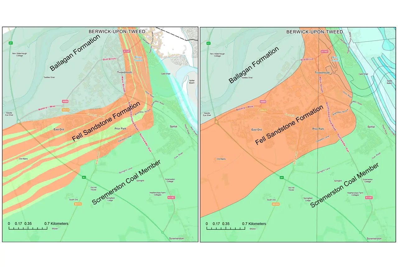
Side-by-side image of new (left) and old (right) bedrock geological maps of Berwick-upon-Tweed. BGS © UKRI.
The new geological mapping and groundwater modelling have revealed that the local aquifer system is more complex than previously thought, with compartmentalisation of the groundwater system within the Fell Sandstone Formation aquifer as well as connectivity between the aquifer and water-bearing sandstone bodies in the adjacent rock formations. This work is informing a programme of borehole drilling by the EA to further develop our understanding of the interactions between water-bearing sandstones in Fell Sandstone Formation and underlying strata, and the implications for future water supply.
The new geological maps are being used as inputs for groundwater modelling, which is a key tool to better understand the controls on groundwater flow within the aquifer. Developing our understanding of the connectivity within the aquifer system is critical for assessing the effects of abstractions and evaluating the potential impacts of both changes in usage and changes in climate, helping to ensure the groundwater resource can support the region well into the future.
Tim Kearsey, head of BGS Integrated Geology.
The geological map data produced from this work will form part of the national geological map and will be freely accessible via the Onshore GeoIndex in its next update. More information on the mapping of Berwick-upon-Tweed can be found on BGS’s Story Maps.
Relative topics
Related news

Delving deep into mountains for future water security
16/07/2026
A BGS-led project is using new water-tracing investigation methods, geophysics and modelling to understand how water moves from mountains to the lowlands, helping to improve water security for billions of people.

Updated national 3D model will determine the depth to the solid bedrock beneath our feet
13/07/2026
The BGS Superficial Deposit Thickness Model now includes an elevation model of geological rockhead for the first time, providing important data for civil engineers, geoscientists and environmental scientists.

New geological mapping underway to help manage flooding along the River Tweed
08/07/2026
Scientists are surveying the Tweed catchment for the first time in over 100 years to enhance understanding of localised groundwater and improve flood forecasting.

From archive to discovery: historical mineral reports support gold exploration in Scotland
25/06/2026
Digitised geological records show potential to unlock untapped mineral resources in Ardlochan, Argyllshire.

Ukraine and the UK strengthen their commitment to geological cooperation
10/06/2026
A new Memorandum of Understanding reaffirms the UK’s support of Ukraine’s ambitions to develop its critical mineral resources, paving the way for collaboration through capacity-building programmes.
New geological maps of Berwick-upon-Tweed to help future-proof natural water supply
20/05/2026
Scientists have mapped the geology under the town to better understand the groundwater system to inform decisions around abstraction.
BGS GeoClimate – dataset launch webinar
Event on 02/06/2026
The virtual launch of our new BGS GeoClimate dataset – helping mitigate the economic risk from shrink-swell subsidence. Event recording now available

Updated geological assessment of the Southern North Sea set to underpin future offshore infrastructure development
25/03/2026
The first regional assessment for 30 years will support offshore marine and subsurface planning for the UK’s low-carbon energy infrastructure, including the 2030 target of 45 to 50 GW generated through offshore wind.

New research could help provide a more reliable water supply for millions in rural Africa
24/03/2026
A new BGS-led study has revealed crucial insights into the longstanding challenges affecting the reliability and performance of rural water supply infrastructure in sub-Saharan Africa.

Map of BGS BritPits showing the distribution of worked mineral commodities across the country
18/02/2026
BGS’s data scientists have generated a summary map of the most commonly extracted mineral commodities by local authority area, demonstrating the diverse nature of British mineral resources.

Extensive freshened water confirmed beneath the ocean floor off the coast of New England for the first time
09/02/2026
BGS is part of the international team that has discovered the first detailed evidence of long-suspected, hidden, freshwater aquifers.

Funding secured to help mitigate ground risk in UK construction sector
05/02/2026
The BGS Common Ground project has been awarded new funding to help unlock the value of ground investigation data.