Release of over 500 Scottish abandoned-mine plans
The historical plans cover non-coal mines that were abandoned pre-1980 and are available through BGS's plans viewer.
24/06/2025 By BGS Press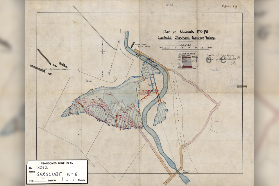

Digital scans of over 500 historical plans of abandoned mines (non-coal) have been released by the National Geoscience Data Centre (NGDC) as part of BGS’s commitment to providing more open, accessible data for its users.
In the late 1800s, the Coal Mines Regulation Act and Metalliferous Mines Regulation Act created the statutory requirement for the deposition of plans of abandoned mines by mine owners to the Secretary of State. In 1980, the BGS Edinburgh office was appointed as the statutory place of deposit for plans of abandoned non-coal and oil shale mines in Scotland. These plans have been preserved and managed by the NGDC, which is NERC’s Environmental Data Service designated geoscience data centre that is hosted by BGS. NGDC collects and preserves geoscientific data and information, making them available for the long term to a wide range of users and communities.
To reflect the BGS’s commitment to more open, accessible data for its users, the decision was taken to make scans of these non-coal mine abandoned plans digitally accessible to the public. This decision comes at an important time when there is increased interest in the potential of mine water for developing geothermal energy technologies. Having these plans openly accessible means they can be used in desk-based studies for those working in the public and private sectors doing site investigations, hazard assessments or further academic research.

NGDC is committed to providing findable, accessible, interoperable and reusable data (FAIR data) and this includes reviewing access to legacy datasets. The release of over 500 plans demonstrates our commitment to being a trusted provider of geological data and knowledge.
Alison Steven, BGS Data Operations and Governance Manger (NGDC).
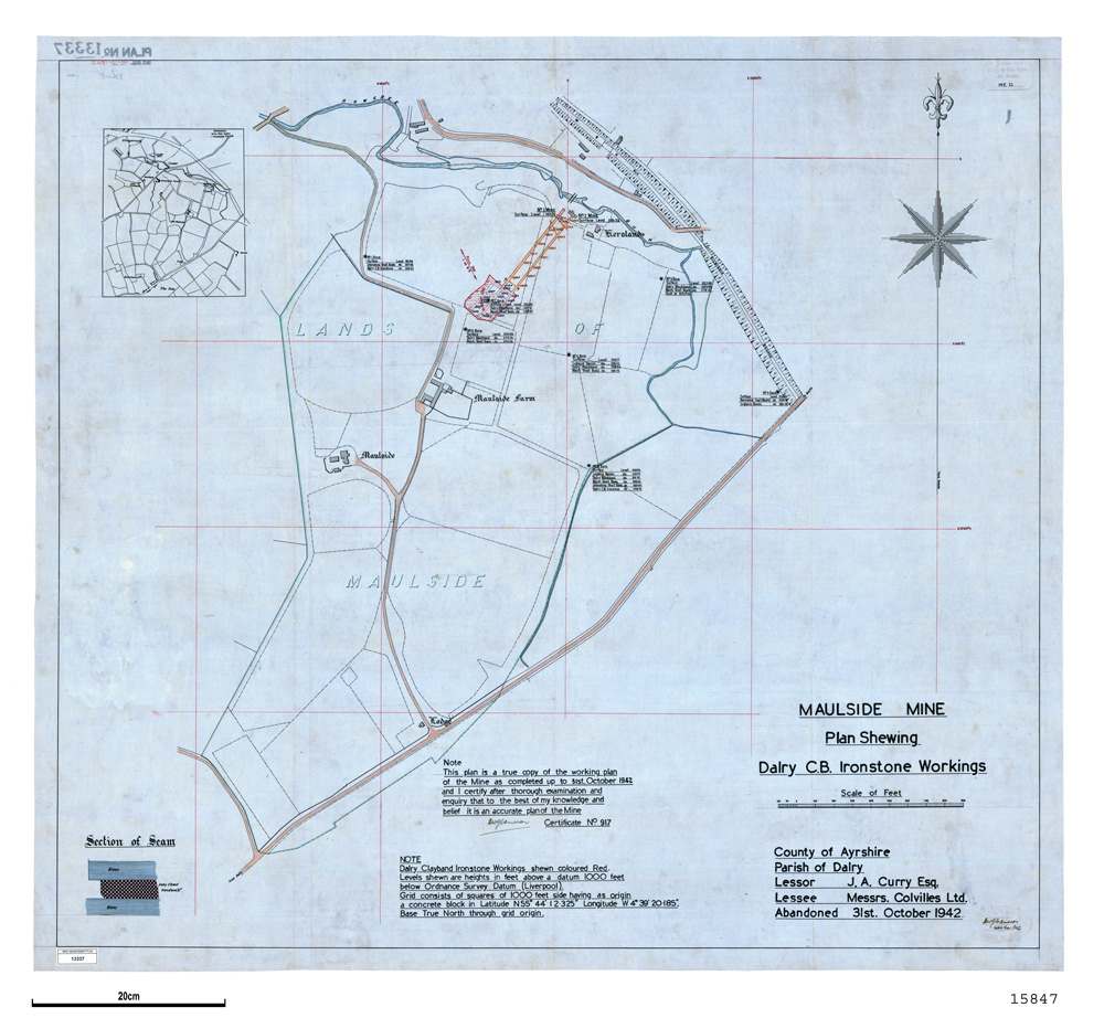
Maulside mine plan showing Dairy CB Ironstone working, Ayrshire. BGS © UKRI.
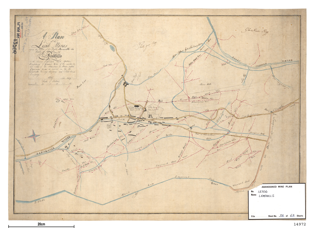
A plan of the abandoned lead mines in Leadhill, Lanarkshire. BGS © UKRI.
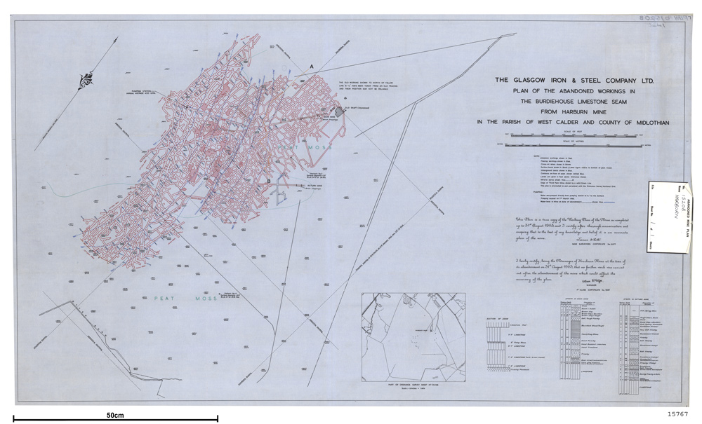
Plan of the abandoned workings in the Burdiehouse Limestone seam at Harburn mine, Midlothian. BGS © UKRI.
The plans can be viewed via the BGS non-coal mining plans viewer and can be filtered by selecting ‘Abandonment plan’ from the plan type drop-down menu.
These abandoned mine plans are part of a collection of over 70 000 plans delivered through the viewer, including sixteen different plan types such as open cast, quarry and cave plans. The portal can be searched by geographical area, mineral or mine name. The information returned includes mine name, mineral, geographical area, plan date (where available), whether a digital copy of the plan is available and who to contact to purchase copies of a scanned plan.
More information
Abandoned mines plans for Northern Ireland can be accessed via the Geological Survey of Northern Ireland webpages.
Further information on the history of non-coal mining plans is available through the BGS website.
Please contact the Mining Remediation Authority for any enquiries relating to coal mine plans in Scotland, England and Wales – or visit their online map viewer.
Relative topics
Related news

From archive to discovery: historical mineral reports support gold exploration in Scotland
25/06/2026
Digitised geological records show potential to unlock untapped mineral resources in Ardlochan, Argyllshire.
Newly released core could hold clues on potential mineral prospectivity in Perthshire
05/06/2026
A comprehensive collection of geological samples from the vicinity of a former mine in Scotland is now available to scientists for further research.

BGS contributes to UN sand and sustainability report
19/05/2026
The new report highlights the impact of poor governance and unsustainable sand mining practices, calling on policymakers to take action.

Map of BGS BritPits showing the distribution of worked mineral commodities across the country
18/02/2026
BGS’s data scientists have generated a summary map of the most commonly extracted mineral commodities by local authority area, demonstrating the diverse nature of British mineral resources.

New 3D model to help mitigate groundwater flooding
08/12/2025
BGS has released a 3D geological model of Gateshead to enhance understanding of groundwater and improve the response to flooding.

World Cities Day: the geological story of our cities
31/10/2025
Understanding the rocks that underlie our towns and cities, the risks they can present and how they influence urban planning and redevelopment.
Why do we store geological core?
11/09/2025
With space at a premium and the advance of new digitisation techniques, why does retaining over 600 km of physical specimens remain of national importance?
BGS artificial ground data: what do you need from a geological survey?
28/08/2025
BGS is seeking user feedback on artificial ground data: how you use it, what information you consider, and what we can do to improve our offering.

New study reveals geological facility’s value to UK economy
19/08/2025
For the first time, an economic valuation report has brought into focus the scale of the National Geological Repository’s impact on major infrastructure projects.
New tool helps identify coal mine gas risk for housing developments in Scotland
05/08/2025
Scientists have co-developed a new tool for North Lanarkshire Council to help screen coal mine gas emissions prior to the development of new houses and buildings.
Release of over 500 Scottish abandoned-mine plans
24/06/2025
The historical plans cover non-coal mines that were abandoned pre-1980 and are available through BGS’s plans viewer.
New data reveals latest mineral workings around Great Britain and Northern Ireland
01/04/2025
The newest release of BGS BritPits provides information on an additional 6500 surface and underground mineral workings.