
Soil chemistry map coverage. BGS © UKRI – Contains OS data © Crown copyright 2020.
Soil chemistry for environmental assessments
- 1:50 000 (or as defined below)
- Great Britain
- Premium
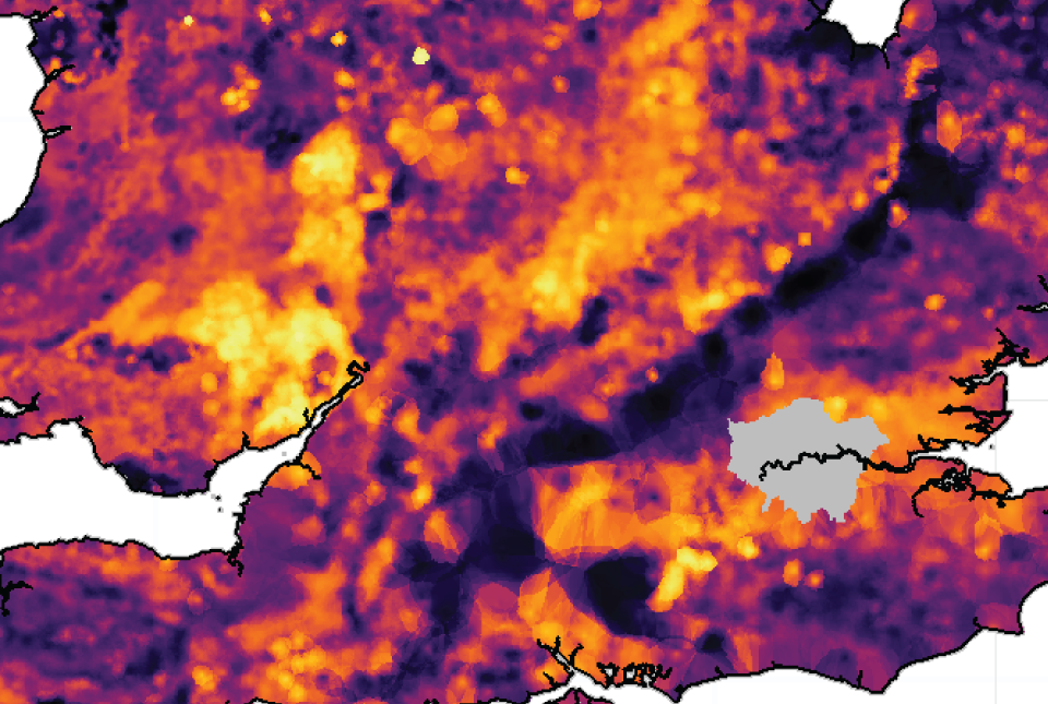
The BGS soil chemistry for environmental assessments dataset, developed from our own G-BASE and Imperial College’s Wolfson Atlas data, contains estimated ambient As, Cd, Cr, Ni and Pb background concentrations for rural topsoils across Great Britain. It also contains the locations and measured concentrations (mg kg-1) of As, Cd, Cr, Cu, Ni, Pb, Sn and Zn in urban topsoil samples, collected from geochemical surveys in 23 major urban centres.
Key information
- Scale:
- 1:50 000 (or as defined below)
- Coverage:
- Great Britain
- Availability:
- Premium
- Price:
£1.36 per km2 for all elements.
£0.35 per km2 for single elements.
Subject to number of users, licence fee and data preparation fee.
- Format:
- GIS polygon and point data. (ESRI, MapInfo, others available by request)
- Uses:
- Local-level to Region-level use
- Themes:
- Environmental change, Geochemistry
Potentially harmful elements (PHEs), including arsenic (As), cadmium (Cd), chromium (Cr), copper (Cu), nickel (Ni), lead (Pb), tin (Sn) and zinc (Zn), can occur naturally in the environment and as a result of anthropogenic pollution. Under certain circumstances they can be harmful to plants, animals or people. Whether or not a particular PHE constitutes a hazard depends on a variety of factors including:
- its chemical form, concentration, behaviour and the extent to which it may be taken up by living organisms
- the size of the mineral particles in which the element occurs
- soil or water acidity (pH)
- the type of vegetation cover
- the extent of exposure to the element
- the dose received
Some PHEs are widely distributed in natural (unpolluted) soils depending on the underlying soil parent materials (geology) as well as in a range of anthropogenic sources.
The BGS soil chemistry for environmental assessments dataset, developed from our own G-BASE and Imperial College’s Wolfson Atlas data, contains estimated ambient As, Cd, Cr, Ni and Pb background concentrations for rural topsoils across Great Britain. It also contains the locations and measured concentrations (mg kg-1) of As, Cd, Cr, Cu, Ni, Pb, Sn and Zn in urban topsoil samples, collected from geochemical surveys in 23 major urban centres.
In addition to the measured data, the urban dataset includes estimated concentrations of As, Cd, Cr, Cu, Ni, Pb, Sn and Zn in topsoils across the 23 urban centres. The dataset also now includes estimated bioaccessible data for As and Pb. ‘Bioaccessibility’ is an estimate of the fraction of PHEs released from the soil into solution in the gastrointestinal tract in a form that can potentially be absorbed into the bloodstream.
Whilst the data cannot be used in place of soil sampling during site investigation, the datasets can be used together as part of land-quality assessments to provide context and establish if elevated local measurements in urban areas are the result of significant anthropogenic pollution or if they are representative of the estimated ambient background concentration, that is, mainly related to soil parent material composition.
Estimated bioaccessible As and Pb values are derived using regression modelling based on the relationship between soil total element concentration and the bioaccessible concentration measured in a selected number of samples from the rural and urban soil datasets. However, the relationship between total and bioaccessible PHE concentrations may vary from site to site dependent on whether high PHE concentrations relate to geogenic or anthropogenic sources, as well as a range of soil factors. Consequently, site-specific investigations will be required because the bioaccessible As and Pb data in the BGS soil chemistry datasets are estimated values based on national rather than site-specific predictive models.
Reports generated from this spatial data will help to inform planning decisions and to aid environmental consultants, developers, householders and their legal representatives.
Dataset layers
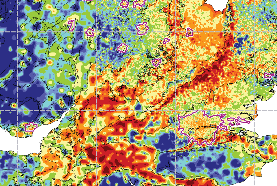
Estimated ambient background soil chemistry
The estimated values provide the likely background concentration of the potentially harmful elements As, Cd, Cr, Ni and Pb in topsoil. The values are estimated primarily from rural topsoil data collected at a sample density of approximately one sample per 2 km2. In areas where rural soil samples are not available, estimation is based on stream sediment data collected from small streams at a sampling density of one sample per 2.5 km2; this is the case for most of Scotland, Wales and southern England. The stream sediment data is converted to soil-equivalent concentrations prior to the estimation.
This data can be used in conjunction with the technical guidance sheets and supplementary information associated with the Contaminated Land Statutory Guidance for the Environmental Protection Act 1990: Part 2A, to assess whether concentrations of elements at a site are likely to fall within the ‘normal’ level prior to site investigation, and to provide context to aid the interpretation of site investigation results.
As, Cr and Ni
Estimated concentrations are computed for a series of geological parent material polygons defined for each 1 km British National Grid square across Great Britain. Each polygon is assigned the geometric mean of the total element concentration (mg kg-1) measured in the five nearest rural topsoil samples collected over the same geological parent material type. For more information see Appleton et al., (2008).
Bioaccessible As is approximated based on predictive regression modelling of the geometric mean total As concentrations for each polygon.
Cd and Pb
Estimated values are computed for each 500 m British National Grid square across Great Britain using an inverse distance weighting function based on the total element concentrations (mg kg-1) in the five nearest measured topsoil samples.
Bioaccessible Pb is approximated based on predictive regression modelling of the estimated topsoil total Pb concentration for each 500 m grid square.
Measured urban soil dataset
The locations and measured total concentrations (mg kg-1) of As, Cd, Cr, Cu, Ni, Pb, Sn and Zn in urban topsoil samples from 23 urban centres across Great Britain. These are collected at a sample density of four per km2.
Estimated urban soil chemistry (1:10 000)
Estimated topsoil chemistry of As, Cd, Cr, Cu, Ni, Pb, Sn and Zn and bioaccessible As and Pb in 23 urban centres across Great Britain. These estimates are derived from interpolation of the measured urban topsoil data referred to above and provide information across each city between the measured sample locations (four per km2). The estimates are calculated in two ways.
Calculation 1: estimated concentrations are computed for each 100 m British National Grid square across each city using an inverse distance weighting function based on the total element concentration (mg kg-1) in the four nearest measured topsoil samples. Bioaccessible As and Pb are approximated based on predictive regression modelling of the estimated topsoil total As and Pb concentrations for each 100 m grid square.
Calculation 2: estimated values are computed for a series of geological parent material polygons defined for each 100 m British National Grid square across each city. Each polygon is assigned the geometric mean of the total element concentration (mg kg-1) measured in the four nearest topsoil samples collected over the same geological parent material type. Bioaccessible As is approximated based on predictive regression modelling of the geometric mean total As concentration for each polygon.
This data can be used in conjunction with the technical guidance sheets and supplementary information associated with the Contaminated Land Statutory Guidance for the Environmental Protection Act 1990: Part 2A, to assess whether concentrations of elements at a site are likely to fall within the ‘normal’ level prior to site investigation, and to provide context to aid the interpretation of site investigation results.
FAQs
References
Appleton, J D, and Adlam, K A M. 2012. Geogenic control on soil chemistry in urban areas: a novel method for urban geochemical mapping using parent material classified data. Applied Geochemistry, Vol. 27(1), 161–170.
Appleton, J D, Rawlins, B G, and Thornton, I. 2008. National-scale estimation of potentially harmful element ambient background concentrations in topsoil using parent material classified soil:stream–sediment relationships. Applied Geochemistry, Vol. 23(9), 2596–2611.
Download BGS sample data
You may also be interested in

London Earth
London Earth is the systematic, high-density, geochemical soil dataset of the Greater London Area (GLA) aiming to give insight into the environmental impacts of urbanisation and industrialisation on the UK’s most populous city.
Soil chemistry for environmental assessments FAQs
Frequenty asked questions for the BGS Soil Chemistry for environmental assessments dataset.
UK: Stream sediment geochemistry
The UK stream sediment geochemistry maps present data compiled from the G-BASE and TellusNI geochemical projects.
UK: topsoil geochemistry
The UK Compiled Topsoil Dataset (UKTS), is the most extensive topsoil geochemistry dataset for the UK.