The Lambeth Group, formerly known as the Woolwich and Reading Beds, occurs in the London and Hampshire basins, where it directly overlies the Chalk Group or Thanet Formation and is succeeded by the Harwich and London Clay formations.
Although generally less than 50 m thick, its lithological variability and position beneath much of London has concerned tunnelling engineers since the early nineteenth century.
Summary of engineering problems encountered with the Lambeth Group
- Rapid changes in lithology
- Clay with irregular water-bearing sand bodies
- Perched water tables
- Hard bands that obstruct boring, drilling, excavations and piling
- Flint-gravel beds, which are water bearing and may restrict boring progress and increase wear of cutting equipment
- Lignite, which may provide differential settlement
- Deposits infilling dissolution features in underlying chalk
- Fissuring of clay, potentially leading to instability in cuts
- De-oxygenation of atmosphere in tunnels cut into Upnor Formation sandstones
Geotechnical properties
Geotechnical data from over 50 ground investigations, held in the National Geotechnical Properties Database, have been analysed to assess the spatial variation in geotechnical properties across the main formations of the Lambeth Group. An example of the undrained shear strength with depth is presented here.
Acknowledgement
The BGS gratefully acknowledges the contribution made to parts of this study by Dr Jackie Skipper (engineering stratigrapher, Natural History Museum) based on her extensive experience of the Lambeth Group geology and its associated engineering problems.
Report download
The Engineering Geology of British Rocks and Soils: Lambeth Group provides an in-depth study of formations within the Lambeth Group using data held in the National Geotechnical Properties Database.
The geological, lithological, geotechnical, and mineralogical features within the Lambeth Group have been described in detail including applicable geophysical methods for ground investigation.
Publications
Entwisle, D C, Hobbs, P R N, Northmore, K J, Skipper, J, Raines, M R, Self, S J, Ellison, R A, and Jones, L D. 2013. Engineering Geology of British Rocks and Soils: Lambeth Group. British Geological Survey Report, OR/13/006. (Nottingham, UK: British Geological Survey.)
Jones, L D. 2001. Determination of the Shrinking and Swelling Properties of the Clays of the Lambeth Group. British Geological Survey Report, IR/01/054. (Nottingham, UK: British Geological Survey.)
Jones, L D, and Hobbs, P R N. 2004. The Shrinkage and Swelling Behaviour of UK soils: the Clays of the Lambeth Group. British Geological Survey Report, RR/04/001. (Nottingham, UK: British Geological Survey.)
Relative topics
You may also be interested in:

Engineering geological studies of bedrock formations
Mapping the engineering geological characteristics, mineralogy, industrial applications, geological hazard potential, physical properties and behaviour of geological formations.
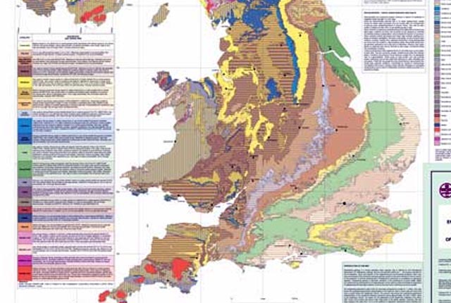
Engineering geology maps
BGS has produced 1:1 million-scale engineering geological maps of the UK, attributed with ‘engineering geological units’ in place of the traditional lithostratigraphical units.