Assessing potential groundwater contamination in the pursuit of new energy sources
23/07/2018 By BGS Press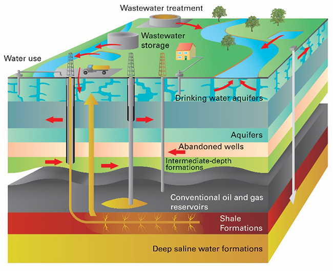

The British Geological Survey (BGS) and the Environment Agency (EA) have developed a method of assessing the vulnerability of groundwater from onshore oil and gas extraction activities in England. This new tool will improve our understanding of the risk to groundwater.
BGS conducted a study to develop an accessible and nationally consistent method for assessing the vulnerability of groundwater to potential contamination from any possible future activities deeper in the subsurface.
The method is based on well-established approaches already employed by the Environment Agency as part of the environmental regulation and permitting process. The UK oil and gas industry is one of the most regulated in the world and so risks to groundwater are already covered in UK law. This new vulnerability assessment will ensure that the UK continues to put safety first when investigating new energy sources.
Groundwater is a vital source of freshwater in England. It provides on average 30 per cent of public water supply. This amount varies between regions, for example in south-east England, it is nearly 90 per cent of public supply. In volume terms, this is over six thousand million litres per day. Enough to fill 2500 Olympic-sized swimming pools, or run a dishwasher 400 million times!
The method uses the BGS’ 3D geological model of England to show the locations of aquifers and rocks which could contain oil and gas. This allows identification of the key parts of the underground water system that might be affected by future hydrocarbon extraction. A tool developed to guide the assessment considers the following elements:
• Classification of the groundwater, i.e. is it an aquifer, how is it used?
• The type of hydrocarbon extraction processes, i.e. hydraulic fracturing?
• The groundwater flow direction, i.e. is it towards or away from the hydrocarbon source?
• The vulnerability of groundwater to underground sources of pollution derived from underground oil and gas activities. This includes factors such as the distance between the potential hydrocarbon source and the aquifer, the thickness of low permeability rocks and potential pathways for pollution i.e. via geological faults, boreholes and mines.
Based on these considerations, an overall risk group can be identified, as can the degree of certainty in this grouping.

Ian Davey, Senior Specialist from the Environment Agency explained: “This tool should help identify vulnerable areas at an early stage and ensure that our groundwater remains protected. We will not issue permits unless a company can demonstrate how it will provide the high level of protection required.”
Dr Rob Ward, Director of Groundwater Science at BGS went on to add: “This method is a first step to understanding the risk to groundwater from these activities. It highlights the value and importance of 3D hydrogeological information for England.”
The method was trialled on five case study sites across England addressing different extraction activities; conventional oil and gas in southeast England, coal bed methane in the East and West Midlands, shale gas in northwest England and shale gas and conventional oil and gas in northeast England.
Most aquifers were rated as being at low risk from contamination. There were occasional instances of medium to low risk ratings for important aquifers with a smaller separation from the oil and gas sources. Medium/high risk groups occur rarely, where important aquifers overlie shale gas and coal bed methane activities. There are no potential receptors in the high risk group in the case studies.
These initial findings are now being made available and we would welcome views on how to develop the methodology further.
For further details or to arrange media interviews please contact:
Sarah Nice, British Geological Survey Press Office, Keyworth, Nottingham, NG12 5GG
Office: +44 (0)115 936 3605 Mobile: +44 (0)7989 115 657
E-mail: sebr@bgs.ac.uk Twitter @Sarahnice1
The following are available for interview:
• Professor Rob Ward, British Geological Survey
• Dr Sian Loveless, British Geological Survey
• Dr John Bloomfield, British Geological Survey
For additional information go to: www.bgs.ac.uk
British Geological Survey
The British Geological Survey (BGS) is a world leading applied geoscience research centre that is part of UK Research and Innovation (UKRI) and affiliated to the Natural Environment Research Council (NERC). BGS core science provides objective and authoritative geoscientific data, information and knowledge to inform UK Government on the opportunities and challenges of the subsurface. It undertakes national and public good research to understand earth and environmental processes in the UK and globally. The BGS annual budget of approximately £60 million pa is funded directly by UKRI, as well as research grants, government commissions and private sector contracts. Its 650 staff work across the UK with two main sites, the head office in Nottingham and Lyell Centre, a joint collaboration with Heriot Watt University in Edinburgh. BGS works with more than 150 private sector organisations, has close links to 40 universities and sponsors about 100 PhD students each year. Please see www.bgs.ac.uk.
Environment Agency
The Environment Agency is here to create a better place for people and wildlife, delivering flood protection and water security, regulating industry and supporting sustainable growth across the country. Please see www.gov.uk/government/organisations/environment-agency