Description
Bedrock exposed between mileage 60.0050 and 60.1630 on the southwest side of Roade cutting south of Courteenhall bridge). The outcrop is loose and unstable and located in the upper part of the slope. The outcrops lie within the railway boundary and the inspection required use of roped access techniques. No outcrop is accessible from the trackside.
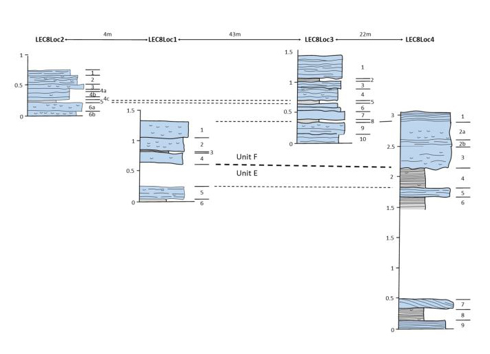
The exposed strata belong to the Blisworth Limestone Formation of the Great Oolite Group (Middle Jurassic). Neither the top or the base of the formation exposed. The strata have been divided into a lower and upper unit based on sedimentology, lithology and fossil assemblages.
Lower unit
The lower unit was observed in locations LEC8Loc1 and LEC8Loc4 and comprises a succession of interbedded peloidal packstone, grainstone and mudstone. The packstones are medium to coarse grained and medium grained peloidal and typically laminated or thinly bedded. Some contain bioclasts and bivalves but these limestones are typically less fossiliferous than the overlying units.

Proposed Log Correlation.
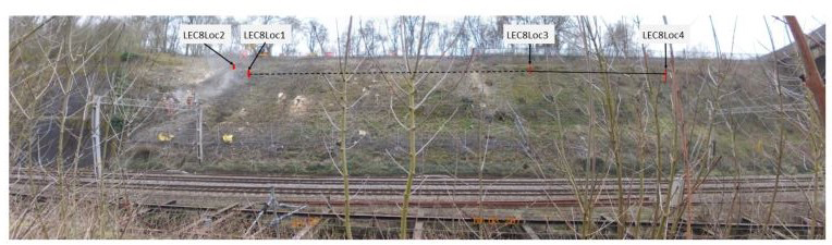
Overview of Exposures.
More sedimentary logs:
Upper unit
The upper unit was observed in all sections and comprises fossiliferous packstones with subordinate mudstone beds and mudstone partings. The beds are oyster rich with common Praeexogyra. Brachiopods Terabratula. Gastropods Nerinea are also present along with echinoderm spines. Bioturbation is common.
Additional Data
| Status of the site/exposure: | To be obscured by slope remediation works in 2017 |
| County or district: | Northamptonshire |
| Ordnance Survey Sheet no: | Landranger 152 1:50 k |
| National Grid Reference(s): | SP74690 52996 |
| BGS 1:50k sheet no: | 185 |
| Date of record: | Jun 15 2017 |
| If a GeoExposure, until when will it be available?: | Jun 30 2017 |
| System/Period of rocks/sediments: | Middle Jurassic |
| Group/Formation/Bed name: | Blisworth Limestone Formation |
| Width of observation (m): | 60 |
| Describe any damage caused by the event you are recording: | Outcrop to be obscured by slope remediation works in 2017 |
| Height of observation (m): | 4 |
| Submitted by: | James Howard |
Report
A report on a geoexposure at in Roade Railway cutting near Courteenhall, Northamptonshire:
Acknowledgements
This data was collected by JBA Consulting on behalf of J. Murphy & Sons Limited with Network Rail at the request of Natural England in order to record the condition of part of the SSSI at Roade Cutting prior to S28H assent for engineering works to stabilise the cutting slope.