Tsunamis are truly global multi-hazardous phenomena. Different mechanisms of generation result in their wide geographic spread and impact. Over the past 20 years, a number of significant events have taken place that have resulted in major advances in our knowledgebase and understanding. It seems that we are living in an ‘age’ of tsunamis.
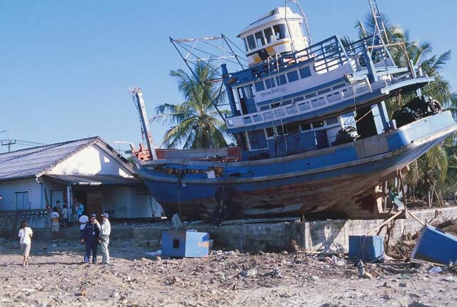

Tsunami damage, Thailand, 2004. BGS © UKRI.
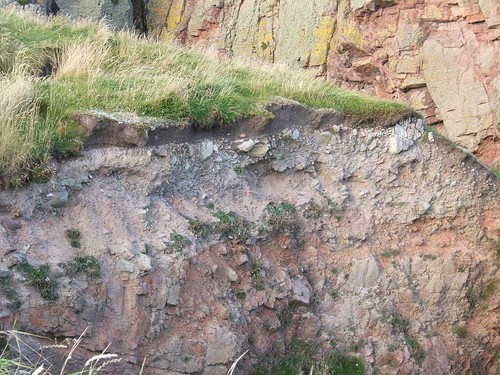
Tsunami deposit, Shetland. BGS © UKRI.
Tsunamis can be caused by vertical seabed movement that causes a change in the height of the sea surface, like a step, travelling through the water column. When it on collapses under the force of gravity, it travels and spreads outward at great speed.
The initial wave may be a few tens of metres high but it rapidly collapses and, in the deep ocean, is less than a metre high. Although the wave is small at this point, its wavelength may be hundreds of kilometres and it is this that allows the wave to travel at great speeds, similar to a jet plane. The wave only becomes dangerous when it approaches land because, due to bottom friction with the seabed, the speed decreases. This causes the wavelength to decrease too and, as it does so, the wave’s elevation increases. As it strikes land it can be tens, if not hundreds, of metres high. With these elevations the wave can be massively destructive.
Earthquakes
Earthquakes are the primary and best-known tsunami trigger mechanism, with major recent events taking place in the Indian Ocean in 2004 and Japan in 2011.
The Indian Ocean tsunami was significant in a number of ways. There were over 220 000 fatalities, mainly of local people but, because of its location in a major tourist region, many Europeans were also involved. The event led to a global recognition of how dangerous tsunamis are. The event also resulted in major re-evaluation of where major earthquakes, termed megathrusts, take place.
But not only earthquakes!
In 1998, a small-magnitude earthquake, located just offshore of northern Papua New Guinea, triggered a small-volume, seabed sediment displacement — a submarine landslide — which resulted in 2200 fatalities on the adjacent coastline. This event led to the recognition that landslides too are a major tsunami hazard.
These three major events (Indian Ocean, Japan and Papua New Guinea) were all located along convergent margins, where the giant tectonic megaplates that form the surface of the Earth collide. Volcanoes are also a major hazard along these margins and, in 1883 in Indonesia, a massive explosive eruption of the Krakatau volcano resulted in a tsunami that caused more than 36 000 fatalities. The blast was heard thousands of kilometres away and dust from the eruption travelled around the world, causing spectacular sunsets.
What about the UK?
The UK is not free of tsunamis. Apart from those tsunamis noted above, there are other locations where they strike, including passive tectonic margins, such as that occupied by the UK and north-west Europe. Here, 8200 years ago off Norway, a massive submarine landslide generated a tsunami that was up to 30 m high when it flooded northern Great Britain. This tsunami is best recorded in Shetland by sediments deposited as the land was flooded.
In southern Great Britain, in the Dover Straits in 1580, it is believed that a cliff fall of the Chalk cliffs north of Dover caused a tsunami that flooded the coast of France.
Not only geological tsunamis
Although most tsunamis are ‘geological’ in that they result from earthquakes, landslides and volcanic eruptions, they are also caused by the weather. These are termed ‘meteotsunamis’.
Geological tsunamis are caused by vertical seabed movement (‘bottom-up’ mechanism), whereas meteotsunamis are caused by changes in atmospheric pressure associated with storms in the North Atlantic. The most recent significant meteotsunami to impact southern Great Britain was in 2011, but the wave was very small so there was no damage. In May 2017, a meteotsunami from a major storm that passed over southern England caused a tsunami that struck the coast of the Netherlands and was several metres high. The tsunami hit popular tourist beaches, but fortunately it was early in the morning, so these were empty.
Case histories
We haves researched all of the recent tsunamis, contributing seminal results.
- Papua New Guinea — submarine mass failures
- Indian Ocean — earthquake
- Japan — earthquake and associated submarine mass failures
- UK tsunamis
- 1850 — coastal landslide
- Ancient northern Great Britain — submarine landslide
- Storegga — important as a giant submarine landslide tsunami
- UK climate change
- Krakatau 1883 — ongoing (NERC standard grant)
- Anak Krakatau — 2018 (NERC urgency grant)
- Palu, Sulawesi — 2018 (NERC urgency grant)
You may also be interested in
Shallow geohazards
Measuring, recording and analysing near-surface geological hazards including landslides, sinkholes and discontinuities.
Landslides
Building resilience both in the UK and internationally to landslides and carrying out many aspects of landslide research.