Sustainable drainage systems (SuDS) are drainage solutions that provide an alternative to the direct channelling of surface water through networks of pipes and sewers to nearby watercourses.
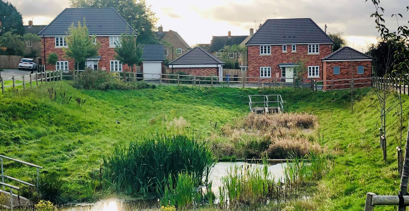

An example of a sustainable drainage system in Derby. BGS © UKRI.
By mimicking natural drainage regimes, SuDS aim to reduce surface water flooding, improve water quality and enhance the amenity and biodiversity value of the environment. SuDS achieve this by lowering flow rates, increasing water storage capacity and reducing the transport of pollution to the water environment.
The need for alternative drainage such as SuDS is likely to increase to meet environmental challenges such as climate change and population growth. Provision for SuDS and the national standards required for their design, construction, maintenance and operation is included in the Flood and Water Management Act 2010.
In natural environments, rain falls on permeable surfaces and soaks into the ground; this process is called infiltration.
In urban areas, where many surfaces are sealed by buildings and paving, natural infiltration is limited. Instead, drainage networks consisting of pipes and culverts divert surface water to local watercourses. In some cases, this has resulted in downstream flooding and deterioration in river water quality. This is caused when foul sewers are overwhelmed by surface water, leading to a release of dirty water into rivers.
SuDS aim to alleviate these problems by:
- storing or re-using surface water at source
- decreasing flow rates to watercourses
- improving water quality
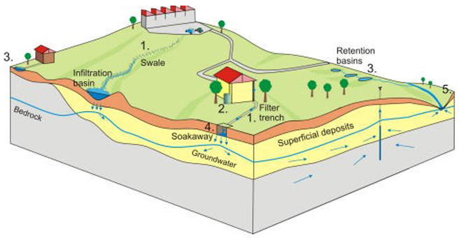
SuDS use a sequence of techniques that together form a management train. As surface water flows through the system, flow velocity is controlled and pollutants are removed. The management train may include the following stages:
- source control methods that decrease the volume of water entering the drainage/river network by intercepting run-off water on roofs for subsequent re-use (e.g. for irrigation) or for storage and subsequent evapotranspiration (e.g. green roofs)
- pre-treatment steps, such as vegetated swales or filter trenches, that remove pollutants from surface water prior to discharge to watercourses or aquifers
- retention systems that delay the discharge of surface water to watercourses by providing storage within ponds, retention basins or wetlands, for example
- infiltration systems, such as infiltration trenches and soakaways, that mimic natural recharge, allowing water to soak into the ground
Our expertise lies in understanding the infiltration capacity of the ground and the potential impacts on ground stability and water quality.
SuDS that infiltrate to the ground rely on the subsurface to accept and store surface water. The properties of the ground are important in deciding where infiltration-based SuDS can be located.
Most importantly, physical and hydrogeological properties determine how easily water will soak into the ground and whether or not it will have an effect on ground stability and water quality.
Will the ground accept water?
For infiltration-based SuDS to drain effectively, the topsoil and the underlying geology need to be free draining.
Sands and gravels, for example, are generally more permeable than silts and clays. Free-draining superficial or bedrock deposits generally have higher porosities and hence more space to provide storage capacity.
Percolating water from SuDS schemes can cause a temporary rise in groundwater level as pore space fills with water. The unsaturated zone (the zone above the groundwater table) must be thick enough to accommodate this groundwater level rise.
What is the potential for ground stability or water quality problems associated with soaking water into the ground?
Release of limited quantities of water into the ground is generally an effective mechanism for surface water disposal.
Depending on the nature of the underlying geology, release of water into the ground may increase the susceptibility to ground stability hazards. It may also impact on water quality.
Ground stability hazards and water quality impacts include:
- voids and collapse features created by the dissolution of soluble rocks and minerals
- down-slope waterlogging leading to increased potential of landslides
- changes in subsurface water content leading to ground compression and subsidence
- groundwater quality deterioration, caused by infiltration of surface water containing contaminants that originate from the surfaces over which it flowed prior to infiltration (whilst pre-treatment (e.g. by incorporating swales or filter trenches) is necessary prior to infiltration of surface water, care is necessary in those aquifers that are used for public water abstractions and in those that have limited capacity to filter contaminants.)
The BGS SuDS Observatory
Our SuDS Observatory was established to identify how SuDS schemes can affect groundwater. The aims of the observatory were to:
- assess the effectiveness of permeable paving in improving recharge to the ground, compared to impermeable surfaces
- assess how effective these systems are at reducing pollution migration from subsurface activities into the shallow subsurface
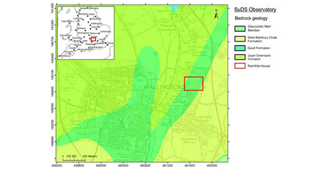
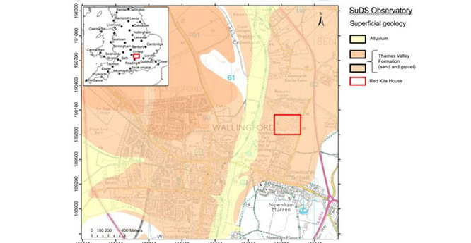
The BGS SuDS Observatory is located at Howbery Park, near Wallingford in Oxfordshire, where a permeable pavement car park was constructed in 2005 outside the Environment Agency offices in Red Kite House. The car park is made up of permeable paving stone at the surface, with a sand and gravel layer and a geotextile for bio-attenuation. The site was designed so that only the car parking bays are permeable and the rest is standard paving blocks.
The underlying geology of the area is made ground and the Thames Valley Formation (sand and gravel), underlain by the basal Glauconitic Marl Member of the West Melbury Marly Chalk Formation (formerly Lower or Grey Chalk).
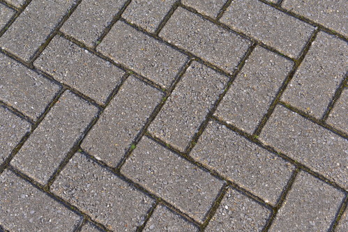
Impermeable paving
Conventional block paving is made of concrete compacted together using sand and is regularly used for car parks, roads and gardens. These areas do not allow water to infiltrate through and water will run over the surface during rainfall events.
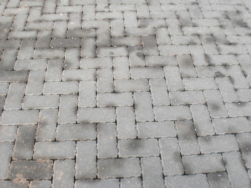
Permeable paving
Permeable paving blocks have uneven edges that create gaps between the blocks. These allow water to flow through them and into the ground below.
To look at how SuDS affect groundwater, two shallow (about 1 m deep) boreholes have been drilled through and underneath the car park paving blocks and soil moisture probes installed. These have been logged continuously and sensed remotely, so that during storm events it is possible to monitor how quickly water moves through the ground beneath the car park.
In order to understand how the volume of groundwater recharge under a SuDS scheme compares to recharge in natural ground, two similar boreholes have been installed in an adjacent field. It is generally assumed in runoff modelling that there is limited infiltration and groundwater recharge in urban areas. This work helps quantify how recharge is enhanced where SuDS are in place.
Soil moisture sensors
The soil moisture probes installed at the observatory are IMKO Pico Profile units, which consist of modular, stackable sections. The units generate a high-frequency pulse, generating an electromagnetic field around the probe. The pulse is reflected back to its source, enabling determination of the propagation velocity, which is primarily dependent on the water content of the subsurface. The units typically measure material about 15 cm outwards from the tubes in which they are mounted and are connected to a datalogger, which can be downloaded either manually to a notebook PC or remotely by telemetry.
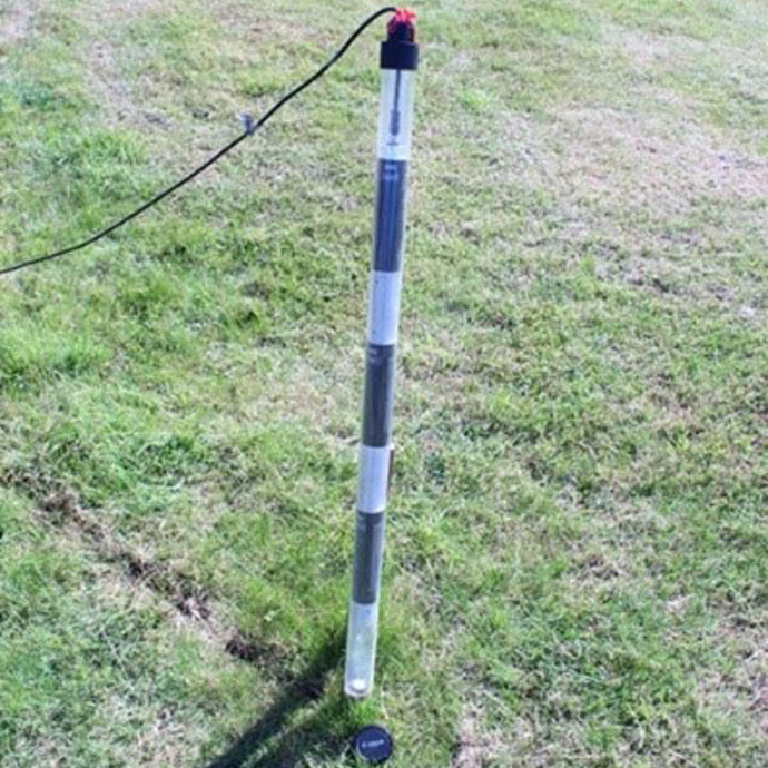
Soil moisture profile probe with 3 x sensors (raised out of access tube). © BGS/UKRI.
The soil moisture probes were tested in a number of materials (soil; sand; gravel) and were trialled during simulated rainfall events before installation to demonstrate their response to these events.
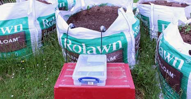
Soil moisture profile probe testing. © BGS/UKRI.
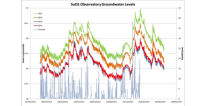
Groundwater levels at the observatory have been measured since 2012, using four shallow boreholes that are located on each of the corners of the car park. These help identify how the groundwater is affected by enhanced recharge, rainfall, the River Thames and regional groundwater flows.
This all helps us build up a conceptual model of the hydrological system at the site. We have also carried out two rounds of groundwater-quality monitoring to look at the baseline quality of water underneath the car park.
Further information
We have existing data and information that can support decisions with regards to the suitability of the subsurface for the installation of soakaway-type systems. These include:
- Infiltration SuDS map: a national GIS map that provides data indicating the suitability of the subsurface for infiltration SuDS
- Infiltration SuDS GeoReport: this site-specific report provides information on the potential for infiltration-to-the-ground to be used as a sustainable drainage technique
- A handy guide for developers (9 MB pdf): developed in partnership with Urben, this guide outlines what developers should consider when designing SuDS and how geological information is beneficial in the process
Archer, N A L, Bell, R A, Butcher, A S, and Bricker, S H. In press. Infiltration efficiency and subsurface water processes of a sustainable drainage system and consequences to flood management. Journal of Flood Risk Management.
Dearden, R. 2014. The science of sustainable drainage. Planet Earth, Autumn 2014, 22–23.
Dearden, R A, Marchant, A, and Royse, K. 2013. Development of a suitability map for infiltration sustainable drainage systems (SuDS). Environmental Earth Sciences, Vol. 70(6), 2587–2602.
You may also be interested in:

Urban geoscience
Providing solutions for urban land-use planning and sustainable development.
Infiltration SuDS map
The BGS Infiltration SuDS map dataset is suitable for those involved in the design of sustainable drainage systems and approving SuDS planning applications.