Key information
Scale:
1:50 000Coverage:
Most of Great BritainAvailability:
Free / LicensedFormat:
GIS line and polygon data. (Shapefile, others available by request)Price:
Free: Available to view as a WMS layer or via the onshore GeoIndex.
Licence: £0.23 per km2 for commercial use. Subject to number of users, licence fee and data preparation fee.
Uses:
Local-level useGet data
Free access
Our free data is available under the Open Government Licence. Please acknowledge reproduced BGS materials.
The Geology Viewer is our online geological viewer intended for general use, the BGS GeoIndex is recommended for professional applications.
GeoIndex ViewerGeology ViewerBGS Geology 50k sample data (Shapefile format)BGS Geology 50k sample data (GeoPackage format)Paid access
Supporting documents
Generalised digital geological map data based on BGS’s New Series 1:50 000 and 1:63 360-scale (one-inch to one-mile) maps with updated nomenclature, including a few 1:100 000-scale maps of Orkney and the Hebrides.
Many BGS geology maps are now available digitally. The Digital Geological Map of Great Britain project (formerly known as DiGMapGB) has prepared 1:625 000, 1:250 000, 1:50 000 and 1:10 000-scale datasets for England, Wales and Scotland. Work continues to upgrade these.
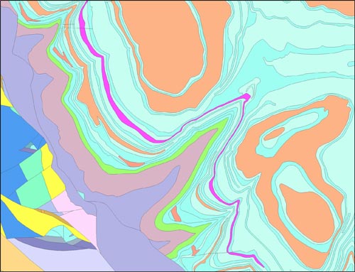

BGS Geology 50K sample. BGS © UKRI.
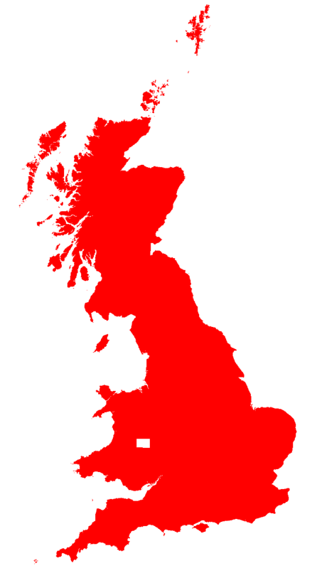
BGS Geology 50K coverage. BGS © UKRI – Contains OS data © Crown copyright 2020
Many existing ‘paper-only’ maps have been digitised and the nomenclature, particularly of older maps, updated to current usage. The geological areas (or polygons) are labelled or attributed with a name based on their lithostratographical, chronostratographical or lithodemic nomenclature and their composition (rock type or lithology). This information is arranged in (up to) four themes as available:
- bedrock geology
- superficial deposits
- mass movement
- artificial ground
Faults and other linear features are available in a separate theme.
Geology maps are the foundation for many other types of earth science-related maps and are of potential use to a wide range of customers.
Further information and resources
Download BGS Geology 50k sample data
You may also be interested in
BGS Geology 10K
Detailed digital geological map data based on BGS’s National Grid and County series 1:10 000, 1:10 560 and 1:25 000 scale maps.

BGS Geology 250K
Generalised digital geological map data based on BGS’s series of 1:250 000-scale maps, reclassified with lithostratigraphic nomenclature.
BGS Geology 625K
Generalised digital geological map data based on BGS’s published poster maps of the UK (north and south).