Please note that, as part of our ongoing programme of application upgrades and redevelopment, the mySoil app has been retired. We would encourage users of this app to migrate to the more extensive UK Soil Observatory (UKSO) map viewer, which allows a wide range of users to work with the latest UK soil research outputs. For more information about this change, please visit our FAQ section.
The mySoil app provided access to European soil properties maps and built a community dataset by allowing users to submit their own soil information.
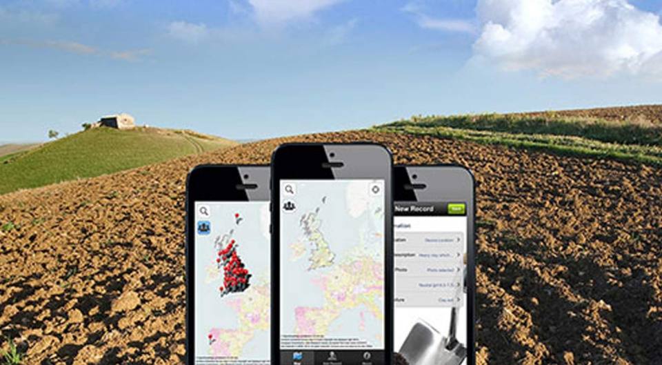

mySoil provided access to comprehensive European soil properties. BGS © UKRI.
Growing our knowledge
mySoil functionality included:
- Access detailed data for the UK
- The latest soil mapping data from across Europe
- Information about the soil beneath your feet with up-to-date information including:
- soil pH
- texture
- depth
- organic matter
- temperature
- A user community which allowed users to submit their own soil data to help better understand this precious resource
mySoil FAQs
The mySoil app has been removed from the app store and is no longer be available to download. The app is no longer be supported and certain functionality will be affected for those who have not deleted the app.
mySoil was launched 10 years ago and is now reaching the end of its life cycle. In the years since it’s launch, BGS has developed services like the UK Soil observatory (UKSO), viewer which enables a wider range of users to access many more datasets. By retiring our legacy applications, we can better invest our resources into our newer, more accessible, applications and viewers, like UKSO, and better support the evolving needs of our users.
MySoil was retired in June 2025.
Yes! The UK Soil Observatory (UKSO) map viewer is an online archive of UK soils data from nine partner organisations. It provides easy access to fully described datasets and allows a wide range of users to work with the latest UK soil research outputs.
The UKSO map viewer can be used by anyone to explore what we already know about UK soils. A large quantity of soil datasets (mostly as maps) are available, including soil type and a range of physical, chemical and biological properties. Each partner organisation has contributed data covering a mix of these topics. Users can also view the data within their own mapping software or applications. In addition, UKSO acts an archive of soil-related resources and information such as other soil apps, publications, events and research projects.
The UKSO map viewer is browser-based and is available across devices capable of viewing web pages, including tablets and smartphones.
We would like to thank all of our contributors to the crowd sourced data in mySoil and UKSO. The valuable data submitted by users of the mySoil application will be available through the ‘Contributions’ layers within UKSO.
How to get in contact about this change?
If you have any comments or questions about this change that is not covered by this page, please contact the BGS Enquiries team.
Partnership
The mySoil app was made possible through collaboration with several major research organisations.
Terms and conditions
By uploading and depositing photos or materials, you, as depositor, do so on the understanding they may be used/re-used by others.
By depositing photos and materials you take full responsibility:
- to ensure that they are owned by you (or you have permission to do so)
- understand that liability regarding their use/re-use may lie with you as depositor
If there are doubts about ownership, check first before making a deposit on BGS citizen science sites.
BGS Citizen Science operates under the code of a Creative Commons Attribution-NonCommercial 3.0 Unported License.
You may also be interested in

Technologies
Applications, software and online services created by the BGS and our collaborators.