On 29 June 2012, a cluster of four small debris flow landslides were reported to BGS on the northern slopes of Ben Reoch, south of Arrochar, Argyll and Bute. Geologists from the BGS Landslide Response Team carried out a survey on 10 July.

Arrochar location map. BGS © UKRI.
The exact date(s) of the landslide events is uncertain, but it is likely that the four events took place over the week of 21–28 June 2012 as a result of heavy rainfall during that period. The landslide flows did not reach the track and railway at the bottom of this slope.
The failure appears to have occurred in saturated soil and head containing gravel and cobbles. It is probable that superficial deposits are thin and discontinuous on the hillside where the landslides occurred. The soil and superficial deposits overlie the Beinn Bheula Schist Formation, of the Southern Highland Group, which is composed of metamorphic rocks of Neoproterozoic age.
These four debris flows are grouped together as National Landslide Database ID NLD 18678/1.
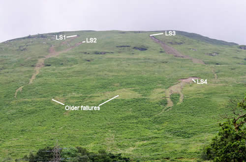
The landslides (marked LS1 to LS4) on Ben Reoch, Argyll and Bute. The line of light green patches at a similar level to LS4 appears to represent a series of older slope failures. BGS © UKRI.
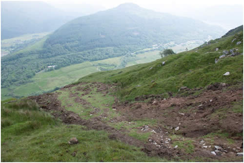
Muddy debris with cobbles on the margins and within the pathway of LS1, forming ridges elongated downslope. BGS © UKRI.
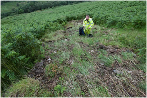
End of pathway of LS4 as delineated by smoothed grass and removal of fern cover, showing small amounts of debris and accumulation of loose vegetation where the slurry came to a halt. BGS © UKRI.
Landslide summary
- The landslides of June 2012 followed a period of enhanced rainfall.
- Small areas of saturated superficial deposits failed and shallow, translational slides took place.
- The landslides moved downhill as debris flows, with much of the mud-rich sediment held on benches on the slope while more fluid slurry containing gravel and cobbles moved as much as 400 m downslope.
- There are no debris lobes where the sediment pathways end.
- There is some evidence for larger, older flows extending close to the railway line at the base of slope.
- The age of these older flows is not known.
Landslide detail
Backscarps
Four small scarps were inspected on Ben Reoch, forming the uppermost parts of the slope failures. The scarps were all narrow, under 10 m in width, and concave downslope. Detachment of material occurred close to the bedrock surface at a depth of between 0.4 and 2 m.
Material has been removed between 10 and 20 m downslope. In LS1, bedrock is not exposed within the scarp but is estimated to be within 0.5 m of the surface. Two of the scarps (LS2 and 3) have excavated material to a length of 20 and 30 m within what appears to have been narrow gullies. In LS4, 3 m of bedrock is exposed in the backscarp.
Debris transport
Below the backscarps, all four landslides have created debris flows whose tracks are marked by removed fern cover and smoothed grass, over which the debris has passed. These pathways contain fragments of bedrock (schist and quartzite) up to small cobble size. Much of the finer-grained flow matrix is concentrated in the upper parts of the pathways, most commonly just below the base of the scarp, or forms linear ridges along the pathway margins.
It appears that, while rock fragments were transported in a slurry to the base of the pathways, much of the mud-rich debris was trapped on several benches or terraces present on the slope. As a result of this, there are no depositional lobes at the bases of the pathways, which are marked by accumulations of loose vegetation carried downslope by the slurry.
Immediately below the gully that contains the backscarp to LS2, the debris pathways of LS1 and 2 coalesce on a bench to form one pathway up to 25 m in width. The pathways branch and thin downslope and are commonly in the region of 1 m in width in their lower parts. Pathways can be followed as much as 400 m downslope.
You may also be interested in

Landslide case studies
The landslides team at the BGS has studied numerous landslides. This work informs our geological maps, memoirs and sheet explanations and provides data for our National Landslide Database, which underpins much of our research.

Understanding landslides
What is a landslide? Why do landslides happen? How to classify a landslide. Landslides in the UK and around the world.

How to classify a landslide
Landslides are classified by their type of movement. The four main types of movement are falls, topples, slides and flows.

Landslides in the UK and around the world
Landslides in the UK, around the world and under the sea.