Swelling and shrinking soils
BGS Research — Shallow geohazards
Shrink–swell, or expansive, soils are one of the most costly and globally widespread geological hazards, with costs estimated to run into several billion pounds annually. These soils present significant geotechnical and structural challenges to anyone wishing to build on or in them.
Quick links
- Shrinking and swelling soils
- What causes shrinking and swelling soils?
- What are the effects of shrink–swell?
- Where does shrink–swell happen?
- Our research
- References
Shrinking and swelling soils
Shrink–swell is the volume change that occurs as a result of changes in the moisture content of clay-rich soils. Swelling pressures can cause heave, or lifting of structures, whilst shrinkage can cause settlement or subsidence, which may be differential.
This shrink–swell behaviour is the most damaging geohazard in Britain today, costing the economy £540 million following a drought in 1991. Heat waves in 2003 and 2006 led to peaks in subsidence claims. More recently, the Association of British Insurers (ABI) reported that over 10 000 households made claims worth a total of £64 million during July to September in 2018 (ABI, 2018). The ABI stated that the 350 per cent increase in the value of claims during July to September 2018 was the highest quarterly jump since records started more than 25 years ago.
In the USA, the estimated damage to buildings and infrastructure exceeds $15 billion annually. The American Society of Civil Engineers estimates that one in four homes have some damage caused by shrink–swell soils; in a typical year, such soils cause a greater financial loss to property owners than earthquakes, floods, hurricanes and tornadoes combined (Nelson and Miller, 1992).
What causes shrinking and swelling soils?
Fine-grained, clay-rich soils can absorb large quantities of water after rainfall, becoming sticky and heavy. Conversely, they can also become very hard when dry, resulting in shrinking and cracking of the ground. This hardening and softening is known as ‘shrink–swell’ behaviour.
Houses in many parts of Britain are affected by shrink–swell-related subsidence. In some places, subsidence can be caused by the movement of the ground with changing weather conditions, for example dry summers or wet winters. The amount by which the ground can shrink and/or swell is determined by:
- the water content in the near surface
- the type of clay in the soil
- the clay’s propensity to change volume
This can be a natural seasonal occurrence or can be enhanced by various means including:
- normal seasonal movements associated with changes in rainfall and vegetation growth
- enhanced seasonal movement associated with the planting, severe pruning or removal of trees or hedges
- changes to surface drainage and landscaping (including paving)
- short-term, unseasonal movements as a result of leaks from water supply pipes or drains
- long-term subsidence as a persistent water deficit develops
- long-term heave as a persistent water deficit dissipates
What are the effects of shrink–swell?
Heave
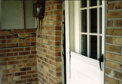
Damage to buildings may occur when the volume change of the soil, due to shrinking or swelling, is unevenly distributed beneath the foundations. For example, if there is a difference in water content in the ground beneath a building, swelling pressures can cause the wall to lift; this is often called ‘heave’. This can happen at the corners or towards the centre of a building.
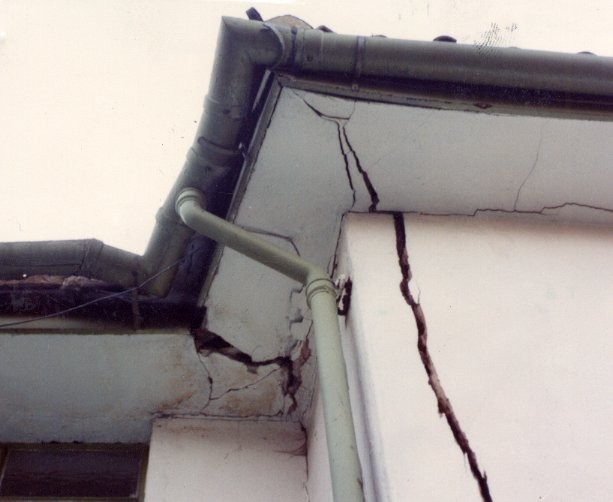

Damage to the corner of a house caused by heave. © Peter Kelsey & Partners.
Damage to the centre of a house caused by heave. © David Noe, Colorado Geological Survey.
Subsidence
Subsidence is a lowering or collapse of the ground. It can be triggered by:
- artificial disturbance
- a change in drainage patterns
- heavy rain
- water abstraction
Subsidence has the potential to cause engineering problems such as damage to foundations, buildings and infrastructure. Subsidence events are sometimes associated with karst processes in soluble rocks or collapse subsidence in mining areas. Subsidence can also occur due to particle re-alignment by water infiltrating a very fine-grained type of soil called loess or compression of compressible soils such as peat. This page focuses on subsidence caused by shrink–swell action.
Dry weather and high temperatures have been found to be a major factor in the emergence of subsidence in clay soils. However, every summer can be completely different to the last; summer 2018 had the hottest, driest June for years whereas summer 2019 had one of the wettest Junes on record. If future predictions of warmer, drier summers and increases in annual temperature and rainfall variability are correct, we can expect more properties to suffer from subsidence due to climate change.
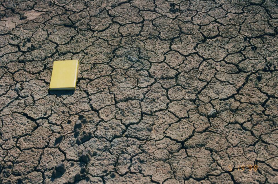
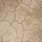
Mud cracks in clays of the Lambeth Group during a prolonged dry period. BGS © UKRI.
As reported by the ABI (2018), the effects of subsidence in a property can usually be seen as cracks in walls that:
- are more than 3 mm thick
- run diagonally across the wall
- are wider from top to bottom
- are visible from inside and outside
- occur near doors and windows
- cause rippling in wallpaper
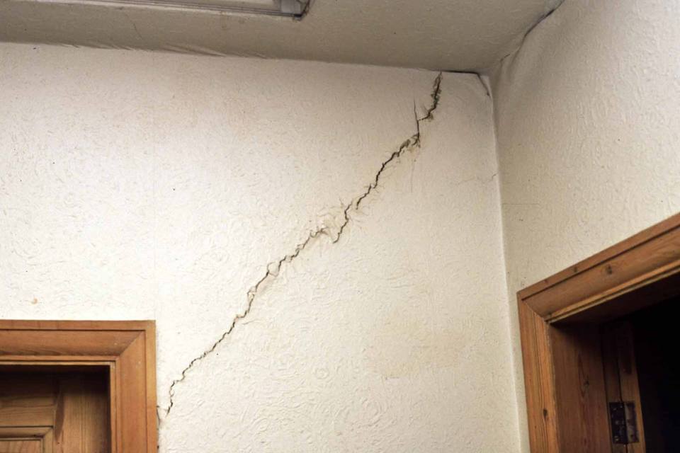
Crack in the wall of a house, caused by subsidence. BGS © UKRI.
However, cracks can also appear on walls for other reasons than subsidence. Settlement, where a building settles under its own weight, can also cause cracks to appear on walls, especially in newly built homes and extensions.
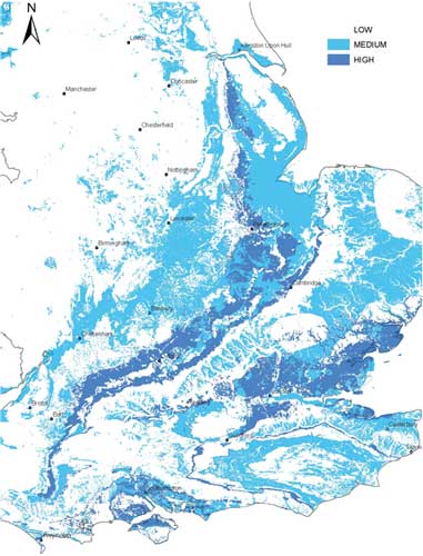
Where does shrink–swell happen?
The rock formations most susceptible to shrink–swell behaviour are found mainly in the south-east of Britain. Here many of the ‘clay’ formations are too young to have been changed into stronger ‘mudrocks’, leaving them still able to absorb and lose moisture. Clay rocks elsewhere in the country are older and have been hardened by burial deep in the Earth and are less able to absorb water. In some areas (e.g. around The Wash and under the Lancashire Plain) they are deeply buried beneath other soils that are not susceptible to shrink–swell behaviour.
Superficial deposits such as alluvium, peat and laminated clays can also be susceptible to soil subsidence and heave (e.g. in the Vale of York and the Cheshire Basin).
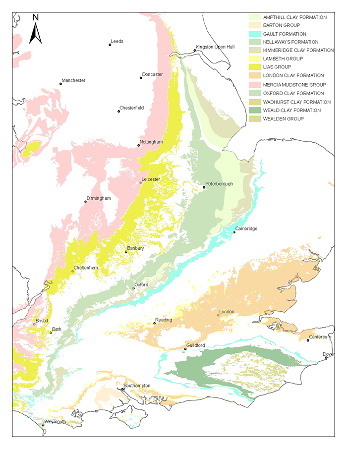
The rock formations most susceptible to shrink–swell behaviour are found mainly in the south-east of Britain. BGS © UKRI.
Our research
Damage may occur as tree roots take up water from the soil, causing the ground to dry out and shrink. Shrinkage can cause uneven settlement leading to subsidence at the surface. This occurs predominantly during spring and summer. The drying results in vertical and horizontal movement of the soil, which may lead to the subsidence of buildings with shallow foundations.
Damage by trees in residential areas
Tree roots grow in the direction of least resistance and where they have the best access to water, air and nutrients. In towns and cities, root growth can cause physical damage to structures by simply pushing the ground apart.
All clays are susceptible to some shrinkage and swelling due to changes in moisture content. Those with a higher proportion of expansive clay minerals, such as smectite, are even more prone. The depth of shrinkage and swelling is contained by the zone where moisture changes are most likely to occur. This is usually the upper 1.5–2 m, but can be up to 5 m, of the subsurface. The depth affected can be greatly influenced by the presence of tree roots and surface cracking.
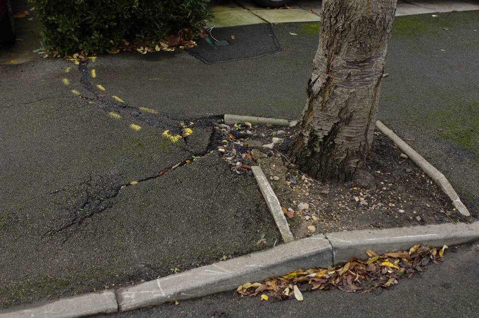
Areas with many older houses and old-style shallow foundations can be seriously affected. A number of London boroughs have seen large numbers of street trees removed due to subsidence-related insurance claims. Recommendations on the safe planting distance of a tree from a building are published. However, existing trees also affect the foundations beneath houses.
Paving of driveways
Paving of previously open areas of land, such as the building of patios and driveways, can cause major disruption to the soil moisture system.
Paving an area with low-permeability materials such as concrete increases water run-off and reduces the amount of rain water that can soak into the ground. If the paving cuts off infiltration, many trees will send their roots deeper into the ground or further from the trunk in order to find water. The movement of these tree roots will cause disturbance of the ground and will lead to the removal of water from a larger area around the tree.
This situation may be made worse as trees continue to extract water during the growing months, when rainfall is low. If a more permeable type of surface, such as block paving, is used, more rain water can enter the ground and supply nearby tree roots.
| Concrete | Clay Soil | Asphalt | Block Paving | Road Surface | Sandy Soil |
|---|---|---|---|---|---|
 |  |  |  |  |  |
| Low | High |
If paving becomes cracked and open due to the action of tree roots, large amounts of water can enter the ground, causing clay-rich soils to expand and swell, possibly causing heave damage. The impact of paving will depend upon a number of factors including:
- soil type
- slope of the ground
- type and size of tree
- type of paving used
GeoSure is a BGS product that gives an indication of ground stability and the potential for ground movement or subsidence. It includes data for collapsible deposits, compressible ground, landslides (slope instability), running sand, shrink–swell and soluble rocks (dissolution).
The shrink–swell layer is based on properties of both bedrock and superficial deposits and also takes into account areas where bedrock is covered by superficial deposits. The resultant map shows areas susceptible to shrink–swell, with the potential for soil-volume change subdivided into very high, high, medium, low or nil.
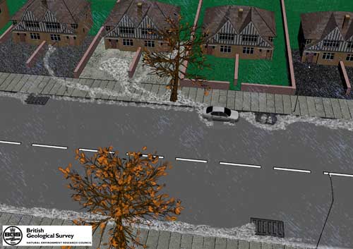
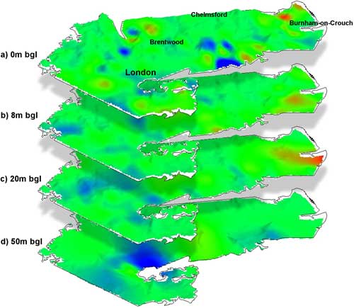
3D volume-change potential mapping, London
All clays are susceptible to some shrinkage and swelling due to changes in moisture content. Those with a higher proportion of expansive clay minerals, such as smectite, are even more prone. The amount by which a soil changes in volume as it dries or becomes saturated is known as its volume-change potential (VCP) and this in turn is reflected by shrinkage and swelling of the ground.
The VCP indicates the potential of a soil to change in volume due to a change in soil moisture. Soils with high or very high VCP may easily cause damage to foundations with a small volume change. Soils with low or medium VCP are not likely to expand or shrink by a damaging amount, under normal situations, but may experience such a change in extreme conditions.
Using BGS data from the national geotechnical database, a 3D model for the VCP of the London Clay Formation has been created. This has revealed a significant geographical trend in the VCP of the deposit, confirming an overall increase in plasticity from west to east, but also showing subtle trends with depth.
When the VCP values for the London and Hampshire basins are examined, the results show major differences in the values for the London Clay Basin and the Hampshire Basin.
Selected references
Harrison, M, Jones, L D, Gibson, A, Cooper, A, Wildman, G, and Foster C. 2009. GeoSure Version 5 methodology review: shrink–swell British Geological Survey Internal Report IR/08/092.
Jones, L D, and Hobbs, P R N. 2004. The shrinkage and swelling behaviour of UK soils: clays of the Lambeth Group. British Geological Survey Research Report RR/04/01.
Jones, L D, and Hobbs, P R N. 1998. The shrinkage and swelling behaviour of UK soils: Mercia Mudstone. British Geological Survey Technical Report Series No. WN/98/14.
Jones, L D, and Hobbs, P R N. 1998. The shrinkage and swelling behaviour of UK soils: Gault Clay. British Geological Survey Technical Report Series No. WN/98/14.
Jones, L D, and Terrington, R. 2011. Modelling volume change potential in the London clay. Quarterly Journal of Engineering Geology and Hydrogeology, Vol. 44(1), 109–122.
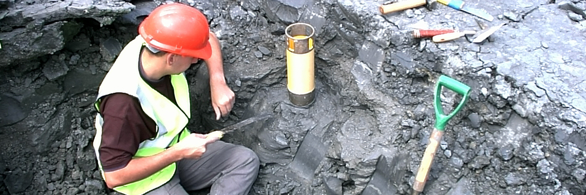
We are collecting samples of each shrink–swell-susceptible rock formation in the UK to test their geotechnical and mineralogical properties and their shrink–swell characteristics. Over time, this will build a comprehensive database for each rock type that will provide planners, engineers and homeowners with information about the hazards posed by shrink–swell.
Currently, research is concentrated on those rock types demonstrating the greatest susceptibility to shrink–swell behaviour and therefore most likely to pose problems in the towns and cities of south-east England. Research into the clays of the Lias Group and the Reading and Gault formations has been successfully completed. Current research is concentrated on the London Clay and the clays of the Weald region.
We carry out detailed geotechnical and mineralogical investigations into rock types known to shrink and we are modelling their properties across the near surface. This research underpins guidance contained in the national GeoSure datasets and is the basis for our responses to local authorities, companies and members of the public who require specific information on the hazard in their areas.
SHRINKiT
To assist with laboratory testing of undisturbed clay samples, we have developed SHRINKiT — an automated measurement system to safely and reliably measure the shrinkage properties of soils.
The standard test, originally devised in the 1950s, used liquid mercury. Not only was this very dangerous, it also produced unreliable results.
To tackle this problem, SHRINKiT uses an automated laser to measure the pattern of volume change as a sample is dried on a moving platform. This produces consistent, reproducible and meaningful results, and is safe to use.
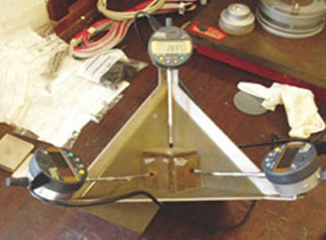
3D swelling strain
The 3D swell-strain apparatus was developed at the BGS by adapting a design taken from the International Society of Rock Mechanics (ISRM). The apparatus measures the orthogonal (X, Y and Z) strains of a cube of clay or mudstone immersed in water and subjected to swelling. The overall volumetric strain is calculated from the data and, if required, the strain anisotropy (different properties in different directions).
The advantage of the design is that does not require leak-proof seals for the strain gauge armatures, as illustrated in the ISRM method.
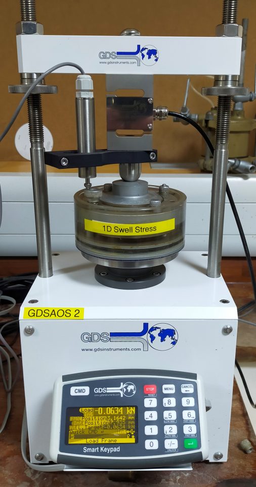
1D swelling pressure
Clay-rich formations are capable of exerting considerable stresses on foundations and services when exposed to an increase in water content from the desiccated (dry) state. The 1D swelling pressure test enables the susceptibility of these formations to shrink–swell to be determined.
The GDS automated 1D swelling-pressure apparatus detects the swelling of the flooded specimen soil using a transducer and an electronic feedback system initiates a vertical force sufficient to counteract the swelling strain, which is applied via the load frame motor. The load is logged and the results are summarised in a plot of swelling pressure versus time.
The test fulfils the specifications of the British Standards swelling pressure tests.
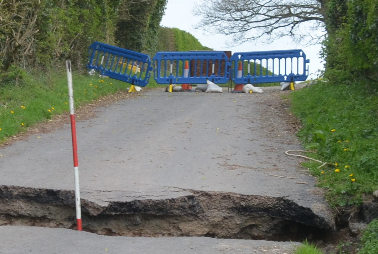
Clay soils are susceptible to shrinking and swelling, and the associated change in volume is one of the causes of subsidence, which is visible when cracks appear in our buildings.
Clay soils (e.g. the London Clay, which is very susceptible to volume change) are found in many areas of the UK, but are most common in the London area and in the south-east of England.
If we have a wet day, does that mean the ground becomes saturated and any concerns of subsidence due to shrinking and swelling clays are out the window?
Unfortunately not! Similarly, when we have a warm sunny day, it does not mean the soil will dry out and cracks will start to appear in the ground and our homes. Rainfall, temperature and climate can all affect shrink–swell.
Rainfall
Recent research investigating the controlling factors of shrink–swell properties of clays has found that the preceding two years of rainfall has a strong influence on the ground saturation and thus the potential of subsidence in our buildings.
So a rainy day, even a rainy month, has to be considered within the context of the rainfall of the preceding two-year period, to assess the potential of shrink–swell today. Once the two-yearly period of rainfall is calculated, only then does this start to give us an indication of the moisture within the ground and the susceptibility of shrinkage. The research has enabled thresholds in rainfall values to be established that suggest high, medium or low likelihood of shrinkage and subsidence occurrence.
Temperature
Temperature has also been found to be influential, with higher temperatures causing more evaporation and evapotranspiration, leading to further drying and shrinking soils.
Climate change
Looking to the future, warmer, drier summers and increases in annual temperature and rainfall variability are suggested for the UK. What is considered a heat wave today is likely to be the norm in the 2050s and cool in the 2080s!
By combining the BGS GeoSure dataset and applying the UK Climate Projections (UKCP) scenarios for rainfall and temperature changes in the UK for the next century, maps have been produced for the south-east of England showing areas with varying vulnerability to shrink–swell and thus subsidence in the future due to climate change. The maps show that areas with clay soils that shrink and swell with changes in moisture are going to become increasingly susceptible in the coming century and beyond.
References
ABI. 2018. [Online search.] Shrink–swell. Accessed 4 September 2020.
Harrison, A M, Plim, J F M, Harrison, M, Jones, L D, and Culshaw, M G. 2012. The relationship between shrink–swell occurrence and climate in south-east England. Proceedings of the Geologists’ Association, Vol. 123(4), 556–575.
Hobbs, P R N, and Jones, L D. 2000. Clay shrinkage research at the British Geological Survey. Slips, Shrinks, and Swells – Clay Minerals and Geotechnics, Joint Meeting of the Clay Minerals Group of the Mineralogical Society and Engineering Group of the Geological Society. Keyworth, Nottingham, December 2000.
Hobbs, P R N, Jones, L D, Kirkham, M P, Gunn, D A, and Entwisle, D C. 2019. Shrinkage limit test results and interpretation for clay soils. Quarterly Journal of Engineering Geology and Hydrogeology, Vol. 52(2), 220–229.
Hobbs, P R N, Jones, L D, Kirkham, M P, Roberts, P, Haslam, E P, and Gunn, D A. 2013. A new apparatus for determining the shrinkage limit of clay soils. Geotechnique, Vol. 64(3), 195–203.
Hobbs, P R N, Jones, L D, Northmore, K J, and Entwisle, D C. 2000. Shrinkage behaviour of some tropical clays. 675-680 in Proceedings of the Asian Conference on Unsaturated Soils. Rahardjo, Toll, D, and Leong (editors), UNSAT-ASIA 2000, Singapore. (Rotterdam: A A Balkema.)
Jones, L D. 2017. Expansive soils. In Encyclopaedia of Engineering Geology. Bobrowsky, P T, and Marker, M (editors). (London, UK: Meteor Springer.)
Jones, L D. 2002. Shrinking and swelling soils in the UK: assessing clays for the planning process. Earthwise, Issue 18, British Geological Survey.
Jones, L D. 2004. Cracking open the property market. Planet Earth, Autumn 2004, 30–31.
Jones, L D, and Jefferson, I. 2012. Expansive soils. 413–441 in ICE manual of geotechnical engineering. Volume 1, geotechnical engineering principles, problematic soils and site investigation. Burland, J (editor.) (London, UK: ICE Publishing.)
Jones, L D, and Terrington, R. 2011. Modelling volume change potential in the London clay. Quarterly Journal of Engineering Geology and Hydrogeology, Vol. 44(1), 109–122.
Jones, L D, Jefferson, I, and Banks, V. 2020. Swelling and shrinking soils. 223–242 in Geological Hazards in the UK: Their Occurrence, Monitoring and Mitigation. Engineering Geology Special Publications 29. Giles, D P, and Griffiths, J S (editors). (London, UK: Geological Society.)
Jones, L D, Lee, K A, and Hulbert A. 2017. London’s subsurface ground space in high demand. Tunnels and Tunnelling.
Lu, P, Rosenbaum, M S, and Jones, L D. 2000. Fractal behaviour of particle size and its implications for describing volume-change in clays. Slips, Shrinks and Swells – Clay Minerals and Geotechnics Conference, Joint Meeting of the Clay Minerals Group of the Mineralogical Society and Engineering Group of the Geological Society. Keyworth, Nottingham, December 2000.
Nelson, J D, and Miller, D J. 1992. Expansive soils—problems and practice in foundation and pavement engineering. (Wiley, New York, USA: Department of Civil Engineering, Colorado State University.)
Contact
If you want to discover more then please contact Lee Jones.
You may also be interested in
Shallow geohazards
Measuring, recording and analysing near-surface geological hazards including landslides, sinkholes and discontinuities.