New research highlights significant earthquake potential in Indonesia’s capital city
Research reveals that a fault cutting through the subsurface of Jakarta could generate a damaging earthquake of high magnitude.
04/11/2025 By BGS Press

The Jakarta Fault runs beneath the southern part of the capital city of Indonesia, Jakarta. Jakarta is one of the largest cities in the world, with a population exceeding 30 million in the metropolitan area. New research by BGS and Indonesian colleagues shows that this fault could generate a magnitude 6.5 earthquake, which would expose a large number of people as well as significantly important economic infrastructure to strong ground shaking.
Between 2019 and 2023, Indonesian scientists from the Institut Teknologi Bandung (ITB), National Research and Innovation Agency (BRIN) and the Geospatial Information Agency (BIG) collected ground movement data across the Jakarta Fault from a dense network of global navigation satellite systems (GNSS). These measurements revealed slow, millimetre-scale changes in ground movement occurring across the fault, which indicated energy accumulating that will need to be released, potentially in a future earthquake.
Geophysical modelling shows that ground movement is accruing on the fault at 3.2 mm per year, with the fault locked or ‘stuck’ down to at least 7.2 km. This accumulation has been happening for at least 210 years, which means that releasing it all now would result in a magnitude 6.5 earthquake.

While magnitude 6.5 earthquakes are not uncommon in Indonesia, they mostly occur under the ocean. The danger here is that the earthquake could occur in the middle of a densely built-up area like Jakarta, which means a much higher level of risk to life and infrastructure.
Dr Ekbal Hussain, remote sensing geoscientist at BGS and research co-leader.
The Jakarta Fault is a relatively newly recognised major tectonic fault on the Indonesian island of Java. It is a part of a broader fault system that cuts across most of Java, which, with a population of 157 million people, is the most densely populated island on Earth. Geophysical surveys conducted by BGS in the 1970s and 1980s, in collaboration with the Indonesian Geological Research and Development Center, helped identify this major tectonic structure for the first time, but its earthquake potential has remained unclear until now.
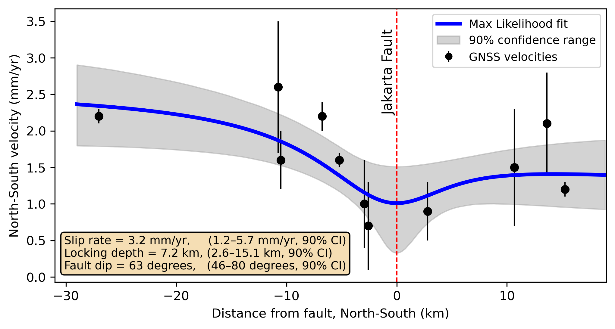
The ground movements across the Jakarta Fault were modelled to estimate the energy storage rate (slip rate) on the fault. Source: Gunawan et al., 2025.
This research forms part of strategic UK/Indonesia research partnerships on geological hazard solutions, as outlined in a recently published White Paper, UK/Indonesia partnerships for advancing geohazard science for disaster risk assessment in Indonesia. The paper, co-developed by key Indonesian and UK hazard experts, presents a strategic roadmap to significantly reducing the impacts of geological hazards in the country. Importantly, it highlights the strength of UK and Indonesian science partnerships for delivering the best disaster resilience science.
More information
Access the full paper: GNSS constraints on the Jakarta Fault, Indonesia: resolving slip rate and seismic hazard potential
Funding
This is work is funded by the UKRI National Capability Geoscience to tackle global environmental challenges programme. The BGS and Indonesian researchers involved in this study are continuing their engagement with local government to address the hazard challenges raised in this work.
Related news

Updated geological assessment of the Southern North Sea set to underpin future offshore infrastructure development
25/03/2026
The first regional assessment for 30 years will support offshore marine and subsurface planning for the UK’s low-carbon energy infrastructure, including the 2030 target of 45 to 50 GW generated through offshore wind.

New research could help provide a more reliable water supply for millions in rural Africa
24/03/2026
A new BGS-led study has revealed crucial insights into the longstanding challenges affecting the reliability and performance of rural water supply infrastructure in sub-Saharan Africa.

Call for new members and Chair to join the NERC facilities steering committees
25/02/2026
New members are needed to join the committees over the next four years.

Your views wanted: developing a geothermal energy subsurface data portfolio
24/02/2026
BGS is aiming to support the growth of the sector by providing the best-available, location-specific geothermal and ground source heat information as an accessible product or service.

Map of BGS BritPits showing the distribution of worked mineral commodities across the country
18/02/2026
BGS’s data scientists have generated a summary map of the most commonly extracted mineral commodities by local authority area, demonstrating the diverse nature of British mineral resources.

Funding awarded to map the stocks and flows of technology metals in everyday electronic devices
12/02/2026
A new BGS project has been awarded Circular Electricals funding from Material Focus to investigate the use of technology metals in everyday electrical items.

New UK/Chile partnership prioritises sustainable practices around critical raw materials
09/02/2026
BGS and Chile’s Servicio Nacional de Geología y Minería have signed a bilateral scientific partnership to support research into critical raw materials and sustainable practices.

Extensive freshened water confirmed beneath the ocean floor off the coast of New England for the first time
09/02/2026
BGS is part of the international team that has discovered the first detailed evidence of long-suspected, hidden, freshwater aquifers.

Funding secured to help mitigate ground risk in UK construction sector
05/02/2026
The BGS Common Ground project has been awarded new funding to help unlock the value of ground investigation data.

Can sandstones under the North Sea unlock the UK’s carbon storage potential?
02/02/2026
For the UK to reach its ambitious target of storing 170 million tonnes of carbon dioxide per year by 2050, it will need to look beyond the current well-studied geographical areas.

Quaternary UK offshore data digitised for the first time
21/01/2026
The offshore wind industry will be boosted by the digitisation of a dataset showing the Quaternary geology at the seabed and the UK’s shallow subsurface.

Suite of ten new soil reference materials released
02/01/2026
BGS has a longstanding track record of producing high-quality reference materials and has released ten new soil reference materials.