Key information
Scale:
N/ACoverage:
SW EnglandAvailability:
FreeFormat:
ESRI grid data (500 m cell size). Printable maps in pdf format. Database tables for survey points.Price:
Free for commercial, research and public use under the Open Government Licence. Please acknowledge the material
Uses:
Local-level useThe Geochemical Baseline Survey of the Environment (G-BASE) is a major BGS project that surveyed the surface geochemistry of Great Britain.
Please note: there are now national-scale datasets available providing Stream Sediment Geochemistry and Topsoil Geochemistry for the UK.
Soil and stream-sediment geochemistry data is available for south-west England as a standalone dataset. The G-BASE geochemical data has been coupled with the Tellus South West collaborative environmental survey and research project funded by the Natural Environment Research Council (NERC). A number of geochemical maps are available for download and to view.
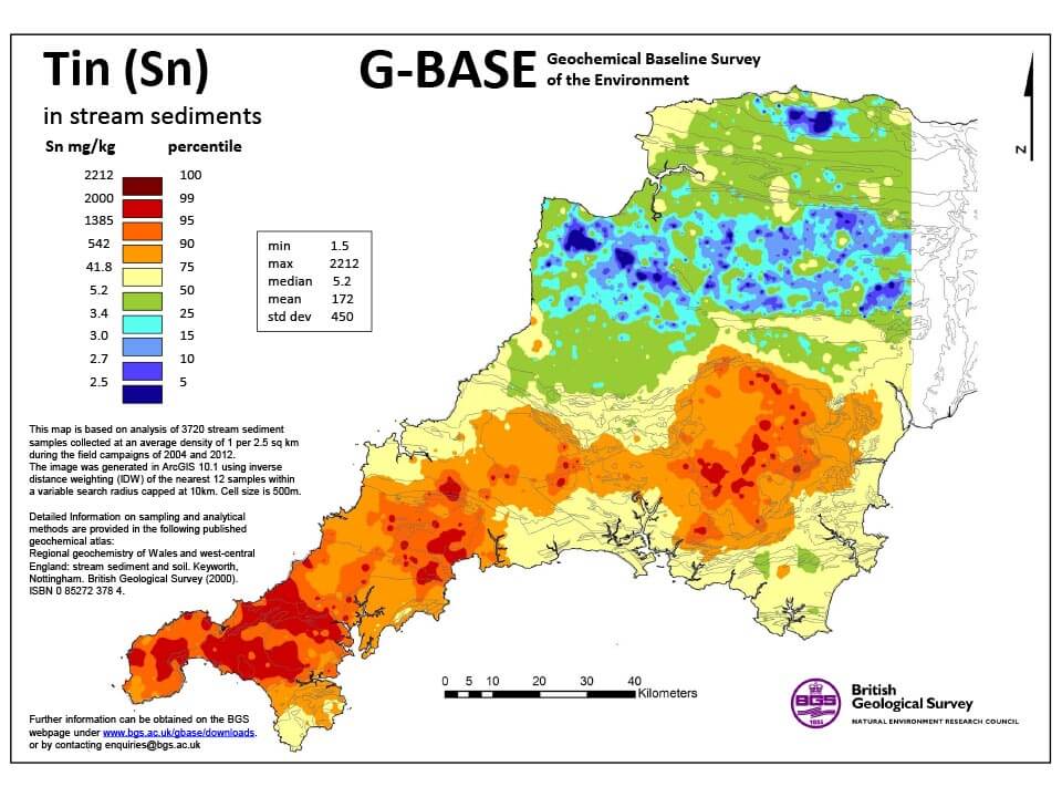

G-BASE for south-west England sample for tin. BGS © UKRI – Contains OS data © Crown copyright 2020.
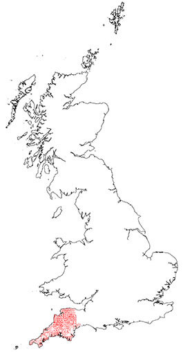
G-BASE for south-west England coverage. BGS © UKRI – Contains OS data © Crown copyright 2020.
Mapping baseline soil and stream-sediment geochemistry on a regional scale provides important chemical information that can be used for a number of purposes including:
- providing a marker of the current state of the environment for the measurement and monitoring of future change
- assessing the condition, health and productivity of soils and sediments for agricultural and ecosystem functions
- identifying and quantifying human impact on the environment, indicating elevated concentrations of potential harmful elements
- identifying new possible sources of mineral potential
These applications are relevant to:
- human and ecological health
- planning and development
- land contamination legislation
- agricultural development
- mineral exploration
We have the expertise to provide underpinning geochemical interpretation of the relationships between the long history of metal mining in south-west England and a legacy of elevated concentrations of metals in river sediments and floodplain soils.
Additional information on our expertise is available.
Methodology and data
The average sample density for stream sediment is approximately one site per 2.5 km2. Density for soil in south-west England is variable across the area, ranging from one per 2 km2 to one per 5 km2, depending on the nature and variability of underlying geological parent material.
Analytical quality is high with strict quality control to ensure continuity with existing national G-BASE geochemical data.
Analytical (X-ray fluorescence) data for the <150 μm fraction of stream sediment and the <2 mm fraction of soil samples are available for some or all of the major and trace elements:
| Aluminium | Copper | Nickel | Tantalum |
| Antimony | Gallium | Niobium | Tellerium |
| Arsenic | Germanium | Phosphorus | Thorium |
| Barium | Hafnium | Potassium | Tin |
| Bismuth | Indium | Rubidium | Titanium |
| Bromine | Iodine | Samarium | Thallium |
| Cadmium | Iron | Scandium | Tungsten |
| Caesium | Lanthanum | Selenium | Uranium |
| Calcium | Lead | Silicon | Vanadium |
| Cerium | Magnesium | Silver | Yttrium |
| Chlorine | Manganese | Sodium | Ytterbium |
| Chromium | Molybdenum | Strontium | Zinc |
| Cobalt | Neodymium | Sulphur | Zirconium |
Major and trace element stream sediment and soil geochemical maps are available to download as pdfs, or to view using the Tellus south-west interactive map viewer. Soil maps can also be viewed at the UK Soil Observatory portal also.
Search the BGS Onshore GeoIndex for the availability of G-BASE soil, stream water and stream sediment data in south-west England.
The downloads are interpolated maps of soil and stream sediment geochemical data based on the analysis of 1154 shallow (5–20 cm) soil samples and 3720 stream sediment samples.
The images for major and trace elements in soil and stream sediment were generated using an inverse distance weighting (IDW) algorithm applied to the nearest 12 samples within a variable search radius capped at 10 km and a cell size of 500 m × 500 m. The interpolated images show element concentrations between known sample points.
The colour ramp is based upon percentile classes of the data distribution.
Information on the concentrations of rare earth elements (REE) in stream sediments is also available.
Soil and sediment geochemical maps and data available for download
Publications
Ferreira, A, Daraktchieva, Z, Beamish, D, Kirkwood, C, Lister, T R, Cave, M, Wragg, J, and Lee, K. 2018. Indoor radon measurements in south-west England explained by topsoil and stream sediment geochemistry, airborne gamma-ray spectroscopy and geology. Journal of Environmental Radioactivity, Vol. 181, 152–171.
Kirkwood, C, Cave, M, Beamish, D, Grebby, S, and Ferreira, A. 2016. A machine learning approach to geochemical mapping. Journal of Geochemical Exploration, Vol. 167, 49–61.
Kirkwood, C, Everett, P, Ferreira, A, and Lister, R. 2016. Stream sediment geochemistry as a tool for enhancing geological understanding: an overview of new data from south west England. Journal of Geochemical Exploration, Vol. 163, 28–40.
Palumbo-Roe, B, Wragg, J, and Cave, M. 2015. Linking selective chemical extraction of iron oxyhydroxides to arsenic bioaccessibility in soil. Environmental Pollution, Vol. 207, 256–265.
Rawlins, B G, O’Donnell, K, and Ingham, M. 2003. Geochemical survey of the Tamar catchment (south-west England). British Geological Survey Commissioned Report CR/03/027N. (Nottingham: British Geological Survey.)
Wragg, J, Cave, M, Hamilton, E, and Lister, T R. 2018. The link between soil geochemistry in south-west England and human exposure to soil arsenic. Minerals, Vol. 8(12), 570.
You may also be interested in
UK: Topsoil geochemistry
The UK Compiled Topsoil Dataset (UKTS), is the most extensive topsoil geochemistry dataset for the UK.

UK: Stream sediment geochemistry
The UK stream sediment geochemistry maps present data compiled from the G-BASE and TellusNI geochemical projects.