Between 2001 and 2011, BGS carried out a series of geochemical surveys in the Clyde Basin forming an integral part of the BGS G-BASE project and the Glasgow and Clyde Basin Urban Super Project (CUSP).
CUSP was a multi-disciplinary catchment-based project to characterise the geoenvironment of the Clyde Basin to aid sustainable planning and development in and around Scotland’s major conurbation.
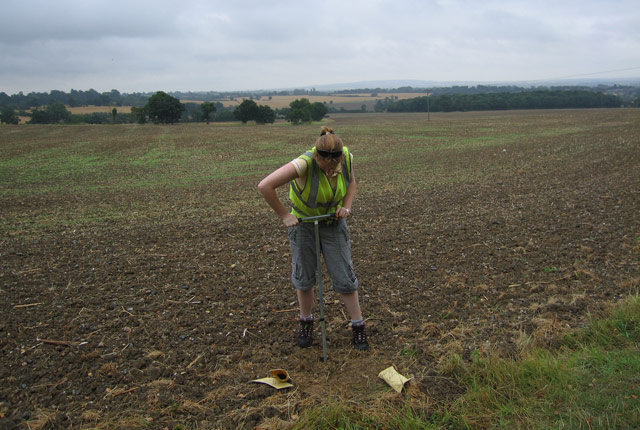
The geochemical surveys were based on the collection of 2000 stream and river sediment/water and 3943 soil samples that were analysed to determine the distribution of c. 50 inorganic chemical parameters that are important for agriculture and/or land and water/sediment quality assessment. Additional studies determined the concentration of c. 50 persistent organic pollutants (POPs) in selected soil and river sediment samples. Results reveal the natural and geological influences on; and the impacts of urbanisation/industrialisation, former mining and atmospheric deposition on soil and drainage system resources. Understanding the controls on soil and surface water/sediment chemical quality provides an invaluable basis to aid catchment management and urban regeneration for the future.
The data shows the chemical state of the surface environment across Scotland’s largest urban area and a key river catchment, against which to assess future change. As demonstrated by the list of publications below, they have application to understanding a variety of environmental issues including:
- land and water chemical quality assessment and regulation
- distribution of potentially harmful substances and diffuse pollution for environmental protection
- distribution of essential trace elements for agriculture and ecosystem health
- soil–surface water–groundwater interactions
- contaminant migration in the River Clyde catchment
- sustainable drainage systems (SuDS)
- catchment management studies
- land use planning and development
- soil carbon stocks
- the data were the first to show a link between soil metal chemistry and deprivation indicators in the UK (See Morrison et al., 2013 in Publication list)
Main outputs
The geochemical surveys were carried out in various phases, with the following main outputs:
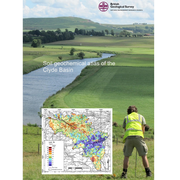
Top (5 – 20 cm) and deeper (35 – 50 cm) soil samples collected across the Clyde Basin at a sample density of 1 per 2 km2 in rural and 4 per 1 km2 in urban areas. Analysed for c. 50 inorganic chemical parameters.
- Soil Geochemical Atlas of the Clyde Basin. 2017. British Geological Survey Open Report, OR/14/032. ISBN 978-0-85272-881-9.
80 urban topsoil (5 – 20 cm) samples from 10 different land use types in Glasgow City. Analysed for c. 100 inorganic and organic chemical substances.
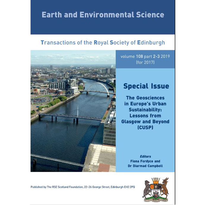
- Earth and Environmental Science Transactions of the Royal Society of Edinburgh. Special Issue: CUSP.2019. Vol.108(2-3).
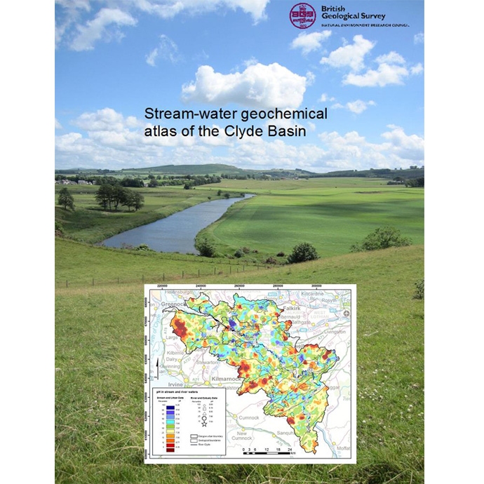
Water samples from small (1st and 2nd order) rural streams, collected at a sample density of 1 per 1.5 km2 from the same sites as the existing 1980s G-BASE stream sediment survey ( ). Analysed for c. 50 inorganic chemical parameters.
- Stream Water Geochemical Atlas of the Clyde Basin. 2017. British Geological Survey Open Report OR/16/015. ISBN 978-0-85272-876-5.
40 river sediment and water samples collected from all junctions with major tributaries on the River Clyde upstream of Glasgow. Sediment analysed for c. 100 inorganic and organic substances. Water analysed for c. 50 inorganic parameters.
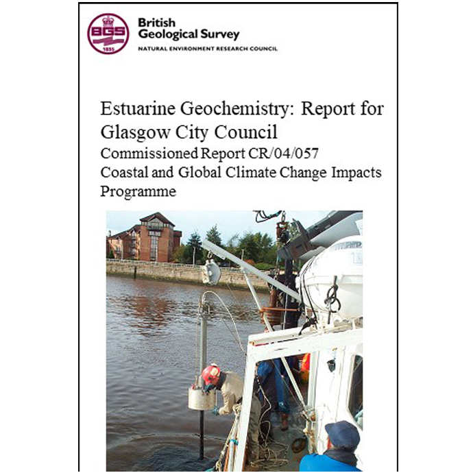
Sediment and water samples collected from the inner and outer estuary of the River Clyde. Analysed for c. 100 inorganic and organic chemical substances.
Carried out in collaboration with Glasgow City Council, the Scottish Environment Protection Agency and Glasgow Humane Society.
- Estuarine Geochemistry: Report for Glasgow City Council. 2004. British Geological Survey Commissioned Report, CR/04/057. Contact BGS Enquiries.
Fine (< 150 µm) fraction urban stream sediment; and stream water collected from every km of length of all tributaries draining into the River Clyde within the Glasgow City area. Analysed for c. 60 inorganic and organic chemical substances.
Carried out in collaboration with Glasgow City Council.
- Clyde Tributaries: Report of Urban Stream Sediment and Surface Water Geochemistry for Glasgow. 2004. British Geological Survey Commissioned Report CR/04/037.
- See also: Clyde Stream-water Geochemical Atlas
Top (5 – 20 cm) and deeper (35 – 50 cm) soil samples collected across the Glasgow conurbation at a sample density of 1 per 2 km2 in rural and 4 per 1 km in urban areas. Analysed for c. 50 inorganic chemical parameters.
- Urban Soil Geochemistry of Glasgow. 2012. British Geological Survey Open Report, OR/08/002.
- See also: Clyde Soil Geochemical Atlas
For all the surveys above, see also the CUSP Special Issue of the Earth and Environmental Science Transactions of the Royal Society of Edinburgh. Links to individual papers in this volume are given in the Publications list below.
- Earth and Environmental Science Transactions of the Royal Society of Edinburgh. Special Issue: CUSP.2019. Vol.108(2-3).
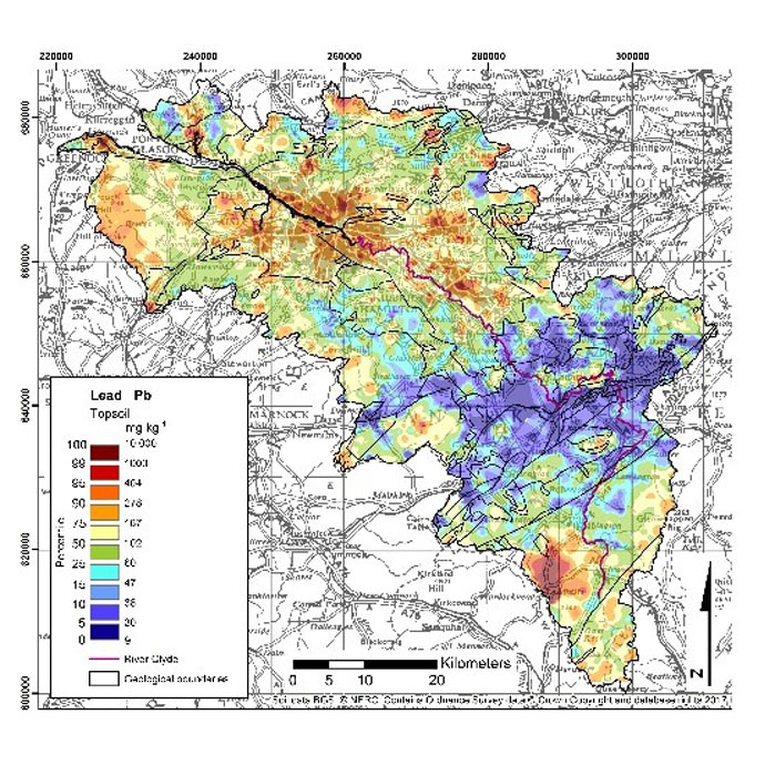

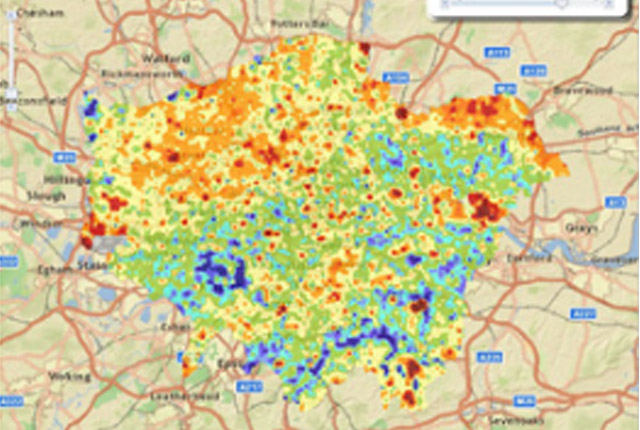
Lead concentrations in Clyde Basin topsoil
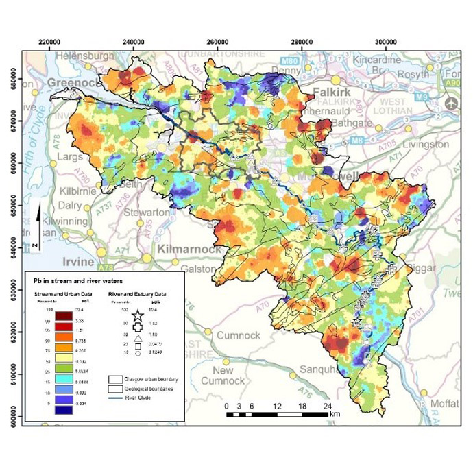
Lead concentrations in Clyde Basin surface water
Data
Data Search the BGS Onshore GeoIndex for the availability of G-BASE soil, stream water and stream sediment data. G-BASE data are available under license from BGS. Contact the BGS enquiry service.
Publications
- Bearcock J M, Smedley P L, Fordyce F M, Everett P A and Ander E L. 2019. Controls on surface water quality in the River Clyde catchment, Scotland, UK, with particular reference to chromium and lead. The Geosciences in Europe’s Urban Sustainability: Lessons from Glasgow and Beyond (CUSP). Earth and Environmental Science: Transactions of the Royal Society of Edinburgh, 108 (2-3), 249–267.
- British Geological Survey. 1993. Regional Geochemical Atlas Southern Scotland and Parts of Northern England. Keyworth: British Geological Survey.
- Fordyce, F M, Ó Dochartaigh, B É, Lister, T R, Cooper, R, Kim, A, Harrison, I, Vane C and Brown, S E. 2004. Clyde Tributaries: Report of Urban Stream Sediment and Surface Water Geochemistry for Glasgow. British Geological Survey Commissioned Report CR/04/037.
- Jones, D G, Lister, T R, Strutt, M H, Entwistle, D C, Harrison, I, Kim, A W, Ridgway, J and Vane, C H. 2004. Estuarine Geochemistry: Report for Glasgow City Council. British Geological Survey Commissioned Report, CR/04/057. Available from the BGS enquiry service.
- Jones D G, Vane C H, Lass-Evans S, Chenery S, Lister T R, Cave M R, Gafeira J, Jenkins G, Leslie A, Breward N, Freeborough K, Harrison I, Kim A W, Lacinska A, Milodowski A, Ridgway J, Riding J, Strutt M, Wagner D and Wilkinson I. 2019. Geochemistry and related studies of Clyde estuary sediments. The Geosciences in Europe’s Urban Sustainability: Lessons from Glasgow and Beyond (CUSP). Earth and Environmental Science: Transactions of the Royal Society of Edinburgh, 108 (2-3), 269–288.
- Lass-Evans S. 2012. Human impact on sediment quality in the Clyde post-industrial catchment, Glasgow. In: Research Conference 2012 – Daphne Jackson Trust Case Studies. Bath, 24 October 2012, 24.
- Lass-Evans, S and Fordyce F M. 2012. Sediment quality in the River Clyde catchment. Scottish Consortium for Rural Research Newsletter 75. 3.
- Lopes dos Santos R A and Vane C H. 2019. Tracking natural organic carbon in the River Clyde, UK using glycerol dailkyl glycerol tetraethers (GDGT). The Geosciences in Europe’s Urban Sustainability: Lessons from Glasgow and Beyond (CUSP). Earth and Environmental Science: Transactions of the Royal Society of Edinburgh, 108 (2-3), 289–298.
- Palumbo-Roe, Barbara; Banks, Vanessa J.; Bonsor, Helen C.; Hamilton, Elliott M.; Watts, Michael J.. 2017. Limitations on the role of the hyporheic zone in chromium natural attenuation in a contaminated urban stream. Applied Geochemistry, 83. 108-120.
- Sim G. 2019. The mobility and speciation of chromium in the urban-industrial environment. PhD Thesis, University of Edinburgh.
- Smedley P L, Bearcock J M, Fordyce F M, Everett P A, Chenery S and Ellen R. 2017. Stream-water Geochemical Atlas of the Clyde Basin. British Geological Survey Open Report OR/16/015. ISBN 978-0-85272-876-5.
- Vane, C.H., Chenery, S.R., Harrison, I., Kim, A.W., Moss-Hayes, V., Jones, D.G. 2011. Chemical Signatures of the Anthropocene in the Clyde Estuary, UK: Sediment hosted Pb, 207/206Pb, Polyaromatic Hydrocarbon (PAH) and Polychlorinated Biphenyl (PCB) Pollution Records. Philosophical Transactions of the Royal Society (A) 369, 1085-1111.
- Vane, C.H., Harrison, I., Kim, A.W. 2007. Assessment of Polyaromatic Hydrocarbons (PAHs) and Polychlorinated Biphenyls (PCBs) in surface sediments of the Inner Clyde Estuary, U.K. Marine Pollution Bulletin, 54, 8, 1301-1306.
- Vane C H, Lopes dos Santos R A, Kim A W, Moss-Hayes V, Fordyce F M and Bearcock J M. 2019. Persistent organic pollutants (PAH, PCB, TPH) in freshwater, urban tributary and estuarine surface sediments of the River Clyde, Scotland, UK. The in Europe’s Urban Sustainability: Lessons from Glasgow and Beyond (CUSP). Earth and Environmental Science: Transactions of the Royal Society of Edinburgh, 108 (2-3), 299–313.
- Vane C H, Moss-Hayes V, Kim A W, Edgley E, Cave M R and Bearcock J M. 2019. Mercury (Hg), n-alkane and unresolved complex mixture (UCM) hydrocarbon pollution in surface sediment across the rural-urban-estuarine continuum of the River Clyde, Scotland, UK. The Geosciences in Europe’s Urban Sustainability: Lessons from Glasgow and Beyond (CUSP). Earth and Environmental Science: Transactions of the Royal Society of Edinburgh, 108 (2-3), 315–326.
- Vane, C.H. Yun-Juan Ma, She-Jun Chen and Bi-Xian Mai. 2010. Inventory of Polybrominated diphenyl ethers (PBDEs) in sediments of the Clyde Estuary, U.K. Environmental Geochemistry & Health, 32(1), 13-21.
Fordyce F M, Lass-Evans S and Ó Dochartaigh, B É. A Case Study to Identify Urban Diffuse Pollution in the Light Burn Catchment, Glasgow, UK. Stage 3 contribution to: Wade, R et al. 2013. A Critical Review of Urban Diffuse Pollution Control: Methodologies to Identify Sources, Pathways and Mitigation Measures with Multiple Benefits. CRW2012/1.Centre of Expertise for Waters (CREW), James Hutton Institute, Aberdeen.
Wade R, Lundy L, Fordyce F M, Berwick N, Jefferies C, McLean N, Lass-Evans S, Ó Dochartaigh B É, Garcia-Haba E, Jose R and Spray C. 2013. Research Summary. A Critical Review of Urban Diffuse Pollution Control: Methodologies to Identify Sources, Pathways and Mitigation Measures with Multiple Benefits. CRW2012/1.Centre of Expertise for Waters (CREW), James Hutton Institute, Aberdeen.
- Appleton J.D., Cave, M.R., Palumbo-Roe, B. and Wragg J. 2013. Lead bioaccessibility in topsoils from lead mineralisation and urban domains, UK. Environmental Pollution 178, 278-287.
- Appleton, J.D., Cave, M.R. and Wragg, J. 2012 Anthropogenic and geogenic impacts on arsenic bioaccessibility in UK topsoils. Science of the Total Environment, 435. 21– 29.
- Appleton, J.D., Cave, M.R. and Wragg, J. 2012. Modelling lead bioaccessibility in urban topsoils based on data from Glasgow, London, Northampton and Swansea, UK. Environmental Pollution, 171. 265-272.
- Broadway, A. 2008. Development of Methodologies for Determination of the Human Bioaccessibility of Chromium and other Elements in Glasgow Soil. PhD Thesis, University of Edinburgh.
- Broadway A, Cave, M R, Wragg J, Fordyce F M, Bewley R J F, Graham M C, Ngwenya B T and Farmer J G. 2010. Determination of the bioaccessibility of chromium in Glasgow soil and the implications for human health risk assessment. Science of the Total Environment, 409 (2), 267-277.
- Campbell, S.D.G., Merritt, J.E., Monaghan, A.A., Mansour, M., Loughlin, S., Hughes, A. G., Ó Dochartaigh, B. E., Fordyce, F. M. and Entwisle, D. 2009. 3D attributed geoscience models and related GIS datasets to assist urban regeneration and resolve environmental problems in and around the Glasgow conurbation, UK. Proceedings from EUREGEO 2009: European Congress on Regional Geoscientific Cartography and Information Systems, Munich, Germany, 9-12 June 2009. Bayerisches Landesamt fur Umwelt, 41-46.
- Campbell, S.D.G., Merritt, J.E., Ó Dochartaigh, B.E., Mansour, M., Hughes, A.G., Fordyce, F.M., Entwisle, D.C., Monaghan, A.A. and Loughlin, S. 2010. 3D geological models and hydrogeological applications: supporting urban development – a case study in Glasgow-Clyde, UK. Zeitschrift der Deutschen Gesellschaft fur Geowissenschaften, 161 (2), 251-262.
- Cundill A, Bacon J, Dale P, Fordyce F M, Fowler D, Hedmark A, Hern A and Skiba U. 2011. Chapter 5: Contamination. In: Dobbie, K.E., Bruneau, P.M.C., Towers, W.(eds). The State of Scotland’s Soil. Natural Scotland. Scottish Environment Protection Agency: Stirling. pp 45-71.
- Farmer J G, Broadway A, Cave, M R, Wragg J, Fordyce F M, Graham M C, Ngwenya B T and Bewley R J F. 2011. A lead isotopic study of the human bioaccessibility of lead in urban soils from Glasgow, Scotland. Science of the Total Environment 409 (23) 4958–4965.
- Flight, D.M.A. and Scheib, A.J. 2011. Soil geochemical baselines in UK urban centres: the G-BASE project. In: Johnson, C., Demetriades, A., Locutura, J., Ottesen, R.T. (Eds.), Mapping the Chemical Environment of Urban Areas. Wiley-Blackwell, Oxford, 186-206.
- Fordyce F M, Brown S E, Ander E L, Rawlins B G, O’Donnell K E, Lister T R, Breward N and Johnson C C. 2005. GSUE: Urban geochemical mapping in Great Britain. Geochemistry: Exploration, Environment, Analysis. Vol. 5(4), 325-336 (12).
- Fordyce F M, Everett P A, Bearcock J M and Lister T R. 2019. Soil metal/metalloid concentrations in the Clyde Basin, Scotland, UK: implications for land quality. The Geosciences in Europe’s Urban Sustainability: Lessons from Glasgow and Beyond (CUSP). Earth and Environmental Science: Transactions of the Royal Society of Edinburgh, 108 (2-3), 191–216.
- Fordyce F M, Everett P A, Bearcock J M, Lister T R, Gowing C, Watts M and Ellen R. 2017. Soil Geochemical Atlas of the Clyde Basin. British Geological Survey Open Report, OR/14/032. ISBN 978-0-85272-881-9.
- Fordyce F M, Nice S E, Lister T R and Ó Dochartaigh, B É. 2013. The chemical quality of urban soils in Glasgow, UK, with reference to anthropogenic impacts and current toxicologically-based soil guideline values. Extended abstracts of the Society for Environmental Toxicology and Chemistry (SETAC) European Conference. 12-16 May 2013, Glasgow. Soil Ecotoxicology III Session Abstract 14129.
- Fordyce F M, Nice S E, Lister T R, Ó Dochartaigh B É, Cooper R, Allen M, Ingham M, Gowing C, Vickers B P and Scheib A. 2012. Urban Soil Geochemistry of Glasgow. British Geological Survey Open Report, OR/08/002.
- Hogg., M. 2010. Relationships between Soil Metal Land Quality and Land Use – a Case Study from Glasgow, UK. MSc Thesis. Cardiff University.
- Kim A W, Vane C H, Moss-Hayes V L, Beriro D J, Nathanail C P, Fordyce F M and Everett P A. 2019. Polycyclic aromatic hydrocarbons (PAH) and polychlorinated biphenyls (PCB) in urban soils of Glasgow, UK. The Geosciences in Europe’s Urban Sustainability: Lessons from Glasgow and Beyond (CUSP). Earth and Environmental Science: Transactions of the Royal Society of Edinburgh, 108 (2-3), 231–247.
- Morrison, S. 2011. Assessment of Geo-environmental Inequalities in the Glasgow Conurbation. MSc By Research Thesis. University of Glasgow.
- Morrison S, Fordyce F M and Scott E M. 2013. An initial assessment of spatial relationships between respiratory cases, soil metal content, air quality and deprivation indicators in Glasgow, Scotland, UK: relevance to the environmental justice agenda. Environmental Geochemistry and Health.
- Rawlins, B G, Vane, C H, Kim, A, Tye, A, Kemp, S and Bellamy, P. 2008. Methods for estimating types of soil organic carbon and their application to surveys of UK urban areas. Soil Use and Management, 24 (1). 47-59.
- Wragg J, Broadway A, Cave M R, Fordyce F M, Palumbo-Roe B, Beriro D, Farmer J G, Graham M C, Ngwenya B T and Bewley J F R. 2019. Linkage between solid-phase apportionment and bioaccessible arsenic, chromium and lead in soil from Glasgow, Scotland, UK. The Geosciences in Europe’s Urban Sustainability: Lessons from Glasgow and Beyond (CUSP). Earth and Environmental Science: Transactions of the Royal Society of Edinburgh, 108 (2-3), 217–230.
- Fordyce F M, Ó Dochartaigh B É, Bonsor H C, Ander E L, Graham M T, McCuaig R and Lovatt M J. 2019. Assessing threats to shallow groundwater quality from soil pollutants in Glasgow, UK: development of a new screening tool. The Geosciences in Europe’s Urban Sustainability: Lessons from Glasgow and Beyond (CUSP). Earth and Environmental Science: Transactions of the Royal Society of Edinburgh, 108 (2-3), 173–190.
- Lovatt M J. 2008. Assessing the Importance of Depth to Groundwater in a Methodology for Prioritising Threats to Groundwater Quality from Surface Contaminants in the Clyde Gateway, Glasgow. MSc Thesis, University of Strathclyde.
- McCuaig, R. 2011. Validation of a GIS-based Tool for Prioritising Threats to Shallow Groundwater Quality from Soil Pollutants in Glasgow. MSc Thesis. Birmingham University.
You may also be interested in:

UK: Stream sediment geochemistry
The UK stream sediment geochemistry maps present data compiled from the G-BASE and TellusNI geochemical projects.
G-BASE: urban geochemistry
An integral part of the G-BASE and TellusNI survey programs was to map and establish the soil geochemical baselines of urban areas in the UK. Systematic geochemical sampling and analysis of soil samples was carried out in 25 urban centres.

Applied geochemistry
Since the 1960s, the BGS has amassed considerable geochemical data holdings and developed significant expertise in applied geochemistry.