
Soil parent material sample. BGS © UKRI.
Soil parent materials model
- 1:50 000
- Great Britain
- Premium
The Soil Parent Material Model details the distribution of physiochemical properties of the weathered and unweathered parent materials of Great Britain. This 1:50 000-scale version contains over 30 rock and sediment characteristics built upon the standard BGS Geology 50K geological dataset, adding simplified classifications of lithological properties.
Supporting documents
Key information
- Scale:
- 1:50 000
- Coverage:
- Great Britain
- Availability:
- Premium
- Price:
£0.35 per km2. Subject to number of users, licence fee and data preparation fee
- Format:
- GIS polygon data. (ESRI, MapInfo, others available by request)
- Uses:
- Local-level use
- Themes:
- Geology, Soils and landscapes
- Sector:
- Agriculture, Weathering and erosion
Soils are the result of weathering processes that occur on the Earth’s surface where the atmosphere meets the geosphere and hydrosphere. We live in this ‘critical zone’, relying on our soils to grow our food and sustain the biodiversity and health of our environment.
A ‘parent material’ is a soil-science name for a weathered rock or deposit from and within which a soil has formed. In Great Britain, parent materials provide the basic foundations and building blocks of the soil, influencing their texture, structure, drainage and chemistry.

Soil parent material sample. BGS © UKRI.

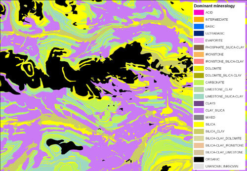
Soil parent map coverage. BGS © UKRI – Contains OS data © Crown copyright 2020.
The Soil Parent Material Model details the distribution of physiochemical properties of the weathered and unweathered parent materials of Great Britain to:
- facilitate spatial mapping of soil properties in Great Britain
- identify soils and landscapes sensitive to erosion
- provide a national overview of our soil resource
- develop a better understanding of weathering properties and processes
Available versions
There are two versions of the Soil Parent Material Model available.
1:50 000 scale
This licensable, 1:50 000-scale version of the Soil Parent Material Model contains over 30 rock and sediment characteristics built upon the standard BGS Geology 50K geological dataset, adding simplified classifications of lithological properties. The attribute content includes a range of information on:
- texture
- colour
- structure
- mineralogy
- lithology
- carbonate content
- genetic origin
One kilometre resolution
The free, 1 km-resolution model details six basic parent-material parameters derived from the 1:50 000-scale version.