Upgraded web portal improves access to geomagnetism data
BGS’s geomagnetism portal, which holds data for over 570 observatories across the world, has received a significant update.
02/06/2025 By BGS Press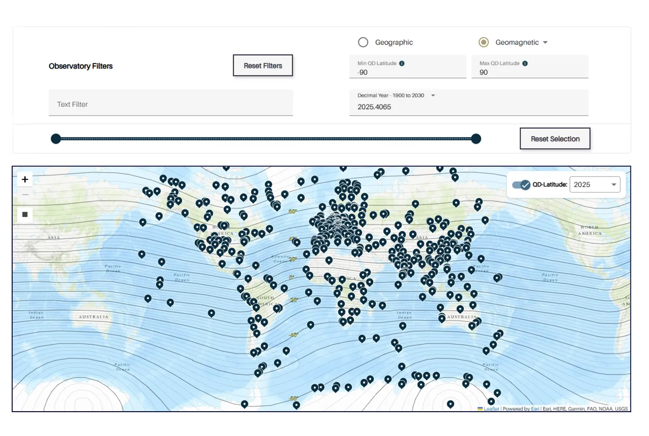

The World Data Centre (WDC) for Geomagnetism, based in Edinburgh, was established in 1966 and is operated by BGS. Its mission is to collate, store and distribute data (and associated metadata) from observations of the Earth’s magnetic field.
As part of this mission, the WDC Data Portal, created by BGS, holds data and metadata on over 570 magnetic observatories around the world and provides open access to these holdings. The data portal was launched at the end of 2024 with a fresh, modern interface providing a step change in accessibility to these important datasets.
The new WDC data portal allows users to plot graphs of geomagnetic data, display availability charts and filter by time or location. It also now offers observatory K-index data as well cadences of minute, hour, day, month and year. Data can be downloaded from the portal in six different text formats, and an API (application/program interface) is available for programmatic access to the data and metadata.
A newly released update has introduced new filters, including magnetic latitude filtering and dip angle filtering. Filtering observatories by magnetic latitude and dip angle is an important tool for academics whose research targets specific phenomena, such as those in the auroral regions or the equatorial electrojet.
The data from the portal can also be used to help produce models, including the International Geomagnetic Reference Field (IGRF), which is created for the public good and is updated every five years to ensure scientists across the world can continue with their forecasts and explorations. The model’s fourteenth update was released in January 2025 and was led by BGS, alongside 18 other institutions from four continents.
One other feature of the new WDC data portal is that makes metadata — the information about the data — more easily accessible to users. This is important as it means users can trust the data and trace its origin.

We are really pleased to announce the recent updates to our geomagnetism portal, which showcases the world’s biggest repository of magnetic field data from ground observatories. The new features and design of the portal mean that it is more user friendly and ensures that more data than ever before is freely accessible to users.
The portal allows models to be created, including IGRF-14, which, in a full circle moment, feeds back into the portal by providing the data for magnetic latitude filtering and dip angle filtering.
Adam Emsley, geomagnetism scientific support and IT specialist at BGS.
In February 2025, the WDC was awarded CoreTrustSeal certification. CoreTrustSeal is an international, community-based, non-governmental and non-profit organisation promoting sustainable and trustworthy data infrastructures. To achieve certification, a data repository must supply evidence demonstrating that it is following good practices and meeting certain standards.
We worked hard on the update of the portal and it is great to see that we have been awarded CoreTrustSeal certification, which highlights that we are a trustworthy data resource.
Adam Emsley, geomagnetism scientific support and IT specialist at BGS.
Access the WDC Data Portal.
Related news

Isotopes and science: my student placement at BGS
08/04/2026
Industrial placements at BGS for undergraduate students give real-life experience of working in laboratories and learning different analytical techniques.

Updated geological assessment of the Southern North Sea set to underpin future offshore infrastructure development
25/03/2026
The first regional assessment for 30 years will support offshore marine and subsurface planning for the UK’s low-carbon energy infrastructure, including the 2030 target of 45 to 50 GW generated through offshore wind.

New research could help provide a more reliable water supply for millions in rural Africa
24/03/2026
A new BGS-led study has revealed crucial insights into the longstanding challenges affecting the reliability and performance of rural water supply infrastructure in sub-Saharan Africa.

Call for new members and Chair to join the NERC facilities steering committees
25/02/2026
New members are needed to join the committees over the next four years.

Your views wanted: developing a geothermal energy subsurface data portfolio
24/02/2026
BGS is aiming to support the growth of the sector by providing the best-available, location-specific geothermal and ground source heat information as an accessible product or service.

Map of BGS BritPits showing the distribution of worked mineral commodities across the country
18/02/2026
BGS’s data scientists have generated a summary map of the most commonly extracted mineral commodities by local authority area, demonstrating the diverse nature of British mineral resources.

Funding awarded to map the stocks and flows of technology metals in everyday electronic devices
12/02/2026
A new BGS project has been awarded Circular Electricals funding from Material Focus to investigate the use of technology metals in everyday electrical items.

New UK/Chile partnership prioritises sustainable practices around critical raw materials
09/02/2026
BGS and Chile’s Servicio Nacional de Geología y Minería have signed a bilateral scientific partnership to support research into critical raw materials and sustainable practices.

Extensive freshened water confirmed beneath the ocean floor off the coast of New England for the first time
09/02/2026
BGS is part of the international team that has discovered the first detailed evidence of long-suspected, hidden, freshwater aquifers.

Funding secured to help mitigate ground risk in UK construction sector
05/02/2026
The BGS Common Ground project has been awarded new funding to help unlock the value of ground investigation data.

Can sandstones under the North Sea unlock the UK’s carbon storage potential?
02/02/2026
For the UK to reach its ambitious target of storing 170 million tonnes of carbon dioxide per year by 2050, it will need to look beyond the current well-studied geographical areas.

Quaternary UK offshore data digitised for the first time
21/01/2026
The offshore wind industry will be boosted by the digitisation of a dataset showing the Quaternary geology at the seabed and the UK’s shallow subsurface.