An integral part of the G-BASE and TellusNI survey programmes was to map and establish the soil geochemical baselines of urban areas in the UK.
Systematic geochemical sampling and analysis of soil samples was carried out in 25 urban centres. Soil samples were collected from two depths (5–20 cm topsoil and 35–50 cm deeper soil) at an average density of four every 1 km2. Samples were collected according to the methods described in the G-BASE Field Procedures Manual. Topsoil samples were analysed by X-ray fluorescence (XRF) for a range of major and trace elements; topsoil pH and loss on ignition (LOI) were also determined. The deeper soil samples were stored in the G-BASE sample archive.
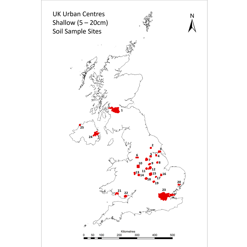

Figure 1: UK Urban Centres Shallow (5-20 cm) Soil Sample Sites. See main outputs section for further information and links to reports.
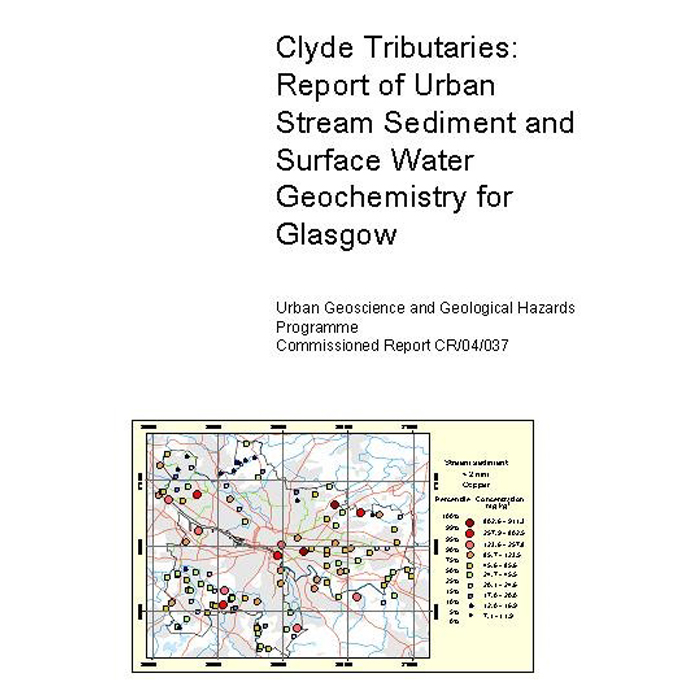
In addition to the standard urban soil dataset, stream sediment and stream water samples were collected within the Glasgow urban area.
The urban surveys were carried out according to the methods outlined in:
- Fordyce, F M, Brown, S E, Ander, E L, Rawlins, B G, O’Donnell, K E, Lister, T R, Breward, N and Johnson, C C. 2005. GSUE: urban geochemical mapping in Great Britain. Geochemistry: Exploration, Environment, Analysis. Vol. 5(4), 325–336.
- Johnson, C C, and Ander, E L. 2008. Urban geochemical mapping studies: how and why we do them. Environmental Geochemistry and Health, Vol. 30(6), 511–530.
- Johnson, C C, Demetriades, A, Locutura, J, and Ottesen, R T (editors). 2011. Mapping the Chemical Environment of Urban Areas. (UK: Wiley Online Library.)
- Johnson, Christopher. 2005. 2005 G-BASE field procedures manual. British Geological Survey, 65pp. (IR/05/097) http://nora.nerc.ac.uk/id/eprint/5190/
The resultant data provides the most extensive set of systematic soil chemical information available for UK urban environments and are used to:
- assess the condition of soil within populated areas.
- identify and quantify human impact on soil in urban areas through comparison with the rural, natural soil geochemical background
- assess pollution and potential risks to the health of ecosystems and humans, as an aid to environmental protection
Applications are relevant to land-use planning and sustainable development, urban regeneration and land contamination legislation.
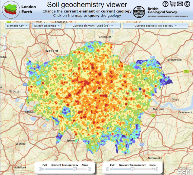
Reports are available for a number of urban centres. Click on the links in the table below to download the reports. Additional information is available for Glasgow and London.
* See Figure 1
| Locality | Urban centre |
|---|---|
| 1 | Glasgow |
| 2 | York |
| 3 | Kingston upon Hull |
| 4 | Scunthorpe |
| 5 | Doncaster |
| 6 | Manchester |
| 7 | Sheffield |
| 8 | Lincoln |
| 9 | Mansfield |
| 10 | Stoke-on-Trent |
| 11 | Derby |
| 12 | Nottingham |
| 13 | Telford |
| 14 | Wolverhampton |
| 15 | Leicester |
| 16 | Peterborough |
| 17 | Corby |
| 18 | Coventry |
| 19 | Northampton |
| 20 | Ipswich |
| 21 | Swansea |
| 22 | Cardiff |
| 23 | London |
| 24 | Belfast |
| 25 | Derry/Londonderry |
For project information and outputs see:
- Clyde Basin
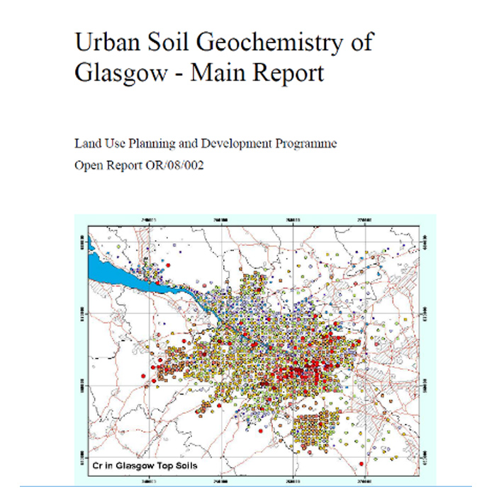
- Urban soil geochemistry of Glasgow
- Clyde tributaries: report of urban stream sediment and surface water geochemistry for Glasgow
The G-BASE, TellusNI and BGS urban geochemical datasets have been used extensively in studies to understand geochemical processes in urban environments to help inform land quality assessments and sustainable urban development.
Stream sediment and stream water
- Controls on surface water quality in the River Clyde catchment, Scotland, UK, with particular reference to chromium and lead.
- Clyde Tributaries: Report of Urban Stream Sediment and Surface Water Geochemistry for Glasgow.
- Geochemistry and related studies of Clyde estuary sediments. The Geosciences in Europe’s Urban Sustainability: Lessons from Glasgow and Beyond (CUSP).
- Human impact on sediment quality in the Clyde post-industrial catchment, Glasgow.
- Sediment quality in the River Clyde catchment.
- Tracking natural organic carbon in the River Clyde, UK using glycerol dailkyl glycerol tetraethers (GDGT).
- The mobility and speciation of chromium in the urban-industrial environment.
- Stream-water geochemical atlas of the Clyde Basin.
- Mercury (Hg), n-alkane and unresolved complex mixture (UCM) hydrocarbon pollution in surface sediment across the rural-urban-estuarine continuum of the River Clyde, Scotland, UK.
- Persistent organic pollutants (PAH, PCB, TPH) in freshwater, urban tributary and estuarine surface sediments of the River Clyde, Scotland, UK.
CREW urban diffuse pollution project
- A Case Study to Identify Urban Diffuse Pollution in the Light Burn Catchment, Glasgow, UK.
- Research Summary. A Critical Review of Urban Diffuse Pollution Control: Methodologies to Identify Sources, Pathways and Mitigation Measures with Multiple Benefits.
Urban soil
- Sources of anthropogenic contaminants in the urban environment.
- Geogenic control on soil chemistry in urban areas : a novel method for urban geochemical mapping using parent material classified data.
- Variation in soil chemistry related to different classes and eras of urbanisation in the London area.
- Lead bioaccessibility in topsoils from lead mineralisation and urban domains, UK.
- Anthropogenic and geogenic impacts on arsenic bioaccessibility in UK topsoils.
- Modelling lead bioaccessibility in urban topsoils based on data from Glasgow, London, Northampton and Swansea,
- Geogenic signatures detectable in topsoils of urban and rural domains in the London region, UK, using parent material classified data.
- Wolverhampton urban environmental survey : an integrated geoscientific case study.
- Concentrations of PAH and PCB in London.
- Ground conditions in central Manchester and Salford : the use of the 3D geoscientific model as a basis for decision support in the built environment.
- Development of Methodologies for Determination of the Human Bioaccessibility of Chromium and other Elements in Glasgow Soil.
- Determination of the bioaccessibility of chromium in Glasgow soil and the implications for human health risk assessment.
- Geochemical baseline data for the urban area of Cardiff.
- Geochemical baseline data for the urban area of Telford.
- The Fate of Contaminants in Urban Soils and Sediments: Novel Assessments and Implications for Risks, Manchester.
- Measuring the solid-phase fractionation of lead in urban and rural soils using a combination of geochemical survey data and chemical extractions.
- GIS as a Tool to Illustrate the Use of Urban Geochemical Data in the Risk Assessment of Hazardous Pollutants.
- A lead isotopic study of the human bioaccessibility of lead in urban soils from Glasgow, Scotland.
- London region atlas of topsoil geochemistry.
- Soil geochemical baselines in UK urban centres: the G-BASE project.
- Urban soils geochemistry and GIS-aided interpretation : a case study from Stoke-on-Trent.
- GSUE: Urban geochemical mapping in Great Britain.
- Soil metal/metalloid concentrations in the Clyde Basin, Scotland, UK: implications for land quality.
- Soil geochemical atlas of the Clyde Basin.
- The chemical quality of urban soils in Glasgow, UK, with reference to anthropogenic impacts and current toxicologically-based soil guideline values.
- Urban Soil Geochemistry of Glasgow.
- Geochemical baseline data for the urban area of Mansfield.
- Geochemical baseline data for the urban area of Sheffield.
- Organic analysis for urban geochemical survey soil samples.
- Relationships between Soil Metal Land Quality and Land Use – a Case Study from Glasgow, UK.
- Understanding the quality of chemical data from the urban environment. Part 1, quality control procedures.
- Urban geochemical mapping studies : how and why we do them.
- London Earth topsoil chemical results : user guide.
- Assessment of Lead and Arsenic Bioavailability in Surface Soils in the Cardiff Area.
- Influence of Geology and Anthropogenic Activity on the Geochemistry of Urban Soils.
- Urban Geochemistry: A study of the influence of anthropogenic activity on the heavy metal content of soils in traditionally industrial and non-industrial areas of Britain.
- Polycyclic aromatic hydrocarbons (PAH) and polychlorinated biphenyls (PCB) in urban soils of Glasgow, UK.
- Land use and lead content in the soils of London.
- Geochemically based solutions for urban society: London, a case study.
- Lability of Pb in soil: effects of soil properties and contaminant source.
- The assessment of point-source and diffuse soil metal pollution in Swansea (Wales, UK) using robust geostatistical methods : a case study in Swansea (Wales, UK).
- The relationship between historical development and potentially toxic element concentrations in urban soils.
- Spatial distribution patterns of phosphorus in top-soils of Greater London Authority area and their natural and anthropogenic factors.
- Identifying geogenic and anthropogenic controls on different spatial distribution patterns of aluminium, calcium and lead in urban topsoil of Greater London Authority area.
- Comparison of methods for addressing the point-to-area data transformation to make data suitable for environmental, health and socio-economic studies.
- Geochemical baseline data for the urban area of Swansea.
- Assessment of Geo-environmental Inequalities in the Glasgow Conurbation.
- An initial assessment of spatial relationships between respiratory cases, soil metal content, air quality and deprivation indicators in Glasgow, Scotland, UK: relevance to the environmental justice agenda.
- Inorganic soil geochemical baseline data for the urban area of the Belfast Metropolitan Area, Northern Ireland.
- Geochemical baseline data for the urban area of York.
- Geochemical baseline data for the urban area of Lincoln.
- Geochemical baseline data for the urban area of Scunthorpe.
- Geochemical baseline data for the urban area of Kingston-upon-Hull.
- Human health risk assessment for exposure to soil at London Road Allotments, Coventry (UK).
- The assessment of point and diffuse metal pollution of soils from an urban geochemical survey of Sheffield, England.
- The use of soil survey data to determine the magnitude and extent of historic metal deposition related to atmospheric smelter emissions across Humberside, UK.
- Presentation of lead and zinc data from soil geochemical surveys of the urban area of Corby and surrounding rural land.
- Methods for estimating types of soil organic carbon and their application to surveys of UK urban areas.
- The impact of urbanization on metals in soils: A case study from Leicester.
- Urban geochemistry: research strategies to assist risk assessment and remediation of brownfield sites in urban areas.
- Polycyclic aromatic hydrocarbons (PAH) and polychlorinated biphenyls (PCB) in urban soils of Greater London, UK.
- Urban geology of Swansea: Neath : Port Talbot.
- Linkage between solid-phase apportionment and bioaccessible arsenic, chromium and lead in soil from Glasgow, Scotland, UK.
- Using Local Moran’s I to identify contamination hotspots of rare earth elements in urban soils of London.
Groundwater and soil pollutants project (GRASP):
- Assessing threats to shallow groundwater quality from soil pollutants in Glasgow, UK: development of a new screening tool.
- Assessing the Importance of Depth to Groundwater in a Methodology for Prioritising Threats to Groundwater Quality from Surface Contaminants in the Clyde Gateway, Glasgow.
- Validation of a GIS-based Tool for Prioritising Threats to Shallow Groundwater Quality from Soil Pollutants in Glasgow.
You may also be interested in

Applied geochemistry
Since the 1960s, the BGS has amassed considerable geochemical data holdings and developed significant expertise in applied geochemistry.