3D geological modelling
3D geological modelling for the 21st century
Introduction
The British Geological Survey (BGS) holds a vast amount of geological data on the subsurface of the UK which is synthesised with geological conceptual understanding into 3D geological models to predict the geology in the subsurface. These range from local to urban scales (typically <100 m below ground level) to regional basin scales (typically several hundred metres below ground level) to national scale models (>2000 m below ground level). 3D geological models are used to inform decision-making in engineering, urban planning, hydrogeological study, mineral exploration, renewable energy, and environmental applications. For example: the BGS have developed a series of 3D geology models and urban study reports to support planning and development within major cities of the UK.
Why 3D?
3D geological modelling has become a key tool for understanding and visualising the challenges associated with the subsurface, and has widespread use across the petroleum, mineral exploration, ground engineering, and geothermal sectors. With comprehensive UK‑wide geological datasets, the BGS is well placed to produce high‑quality 3D geological models that support emerging industries and help address major national challenges, including rising energy demand, increasing susceptibility to geological hazards, and utilisation of subsurface space. The uses of 3D geological models are explained below.
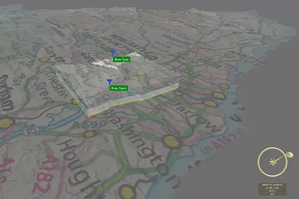
The emergence of groundwater at the surface occurs in a range of geological environments, including areas affected by historical mining. Between 122,000 and 289,000 properties are considered at risk in England (McKenzie et al., 2015). Groundwater flow studies are critical in the Northumbria region due to the long‑standing problem created by historical coal mining. Extensive networks of abandoned mines and worked coal seams, combined with large sandstone channels within the coal measures, allow groundwater to move rapidly through the subsurface and require continuous pumping.
Effective groundwater management became achievable with the introduction of 3D subsurface geological modelling in the Project Groundwater Northumbria (PGN) initiative. By modelling the coal measures and major seams, the project improves understanding of likely groundwater flow pathways, enabling more accurate prediction and mitigation of groundwater flooding.
This approach allows the Environment Agency and Gateshead Council to prioritise resources more effectively, focusing on areas where impacts are greatest and where groundwater is most likely to emerge.
Learn more: Project Groundwater Northumbria case study.
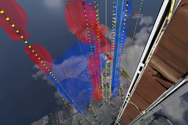
With the increasing focus on the green energy transition, the British Geological Survey (BGS) has taken a leading role in advancing knowledge of subsurface fluid flow and fracture behaviour. This work is supported by state‑of‑the‑art research technologies deployed at the UK Geoenergy Observatory in Cheshire. High‑resolution monitoring systems enable detailed observation of fluid movement through different geological units, made possible through the integration of advanced instrumentation and data acquisition technologies. These insights contribute to the development of a robust 3D geological model of the area, enhancing geological and geothermal understanding to inform future analysis and applications.
Learn more: Cheshire UK Geoenergy Observatory case study.
The BGS has a broad understanding of the regional and national subsurface geology encompassing structural framework, stratigraphy and its practical application for managing aquifer systems, screening for subsurface storage solutions and harvesting resources such as geothermal energy. Through a series of UK‑wide screening projects, the BGS has advanced the conceptualisation of these systems to support strategic high-level decision‑making on their sustainable use.
These initiatives are supported by sophisticated visualisation technologies that facilitate clear communication with both geological specialists and wider stakeholder groups.
Learn more: National and regional scale resource management and screening case study.
The UK construction sector invests approximately £1.2 billion per year in Ground Investigation, yet unforeseen ground conditions still cause significant delays and overspend, estimated at 10 per cent of project costs or £120 million per year. Unforeseen ground conditions are a major factor in these delays and overspends.
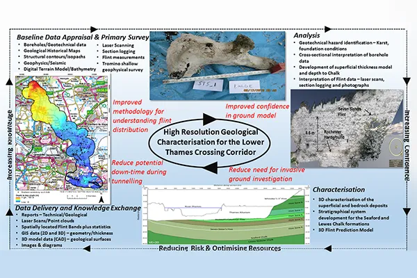
3D geological modelling for major infrastructure projects has proven to mitigate unforeseen ground conditions, helping to synthesise a vast amount of data to help inform on the subsurface geology. The BGS have shown this on Farringdon Station (CrossRail), the Haweswater Aqueduct and the Lower Thames Crossing projects.
Learn more: Lower Thames Crossing case study.
Analysis and data interpretation
The interpretation and data analysis phase are critical and tailored to each model, depending on data availability, geological context, and project objectives. BGS holds a substantial archive of legacy datasets, with specialist expertise available to interpret and apply them effectively from 2D to 3D.
Techniques and expertise include:
- Digital field survey geological mapping-data integration
- Terrain analysis and aerial imagery interpretation
- Borehole core analysis and log interpretation, Borehole records – British Geological Survey
- Seismic data conversion and analysis
- Literature analysis
- Fault and fracture analysis
- Engineering assessments and geotechnical testing
- Third party data integration and analysis e.g. Mining Remediation Authority coal seams, mine abandonment plans and other data
Model workflow and construction
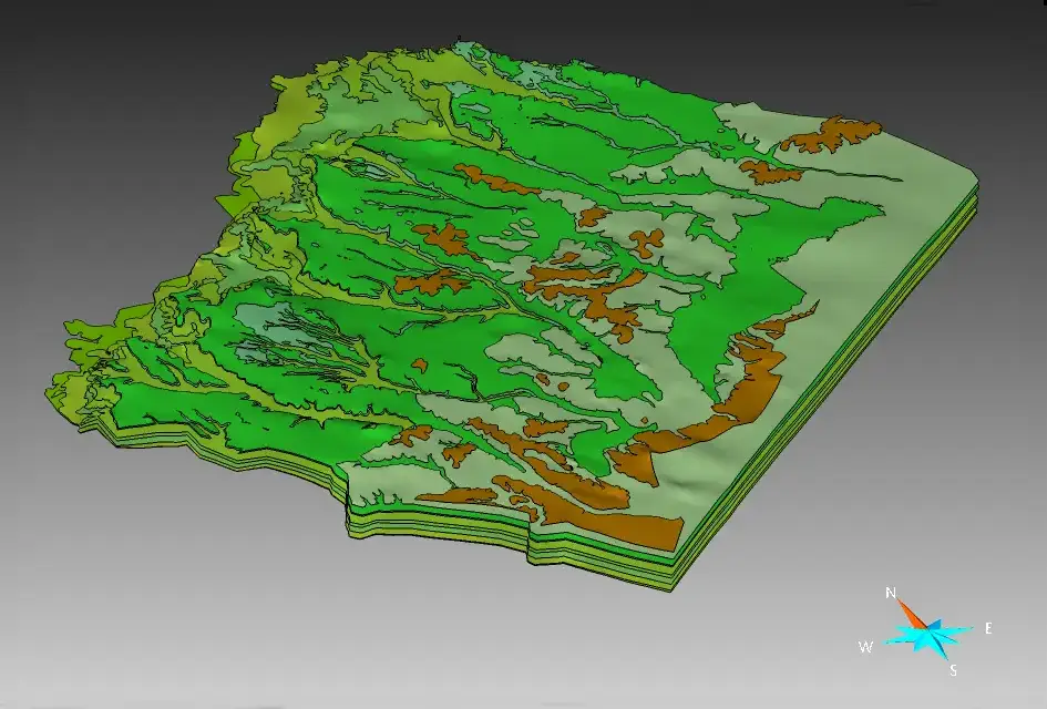
A large portion of the 3D geological modelling process is dedicated to data digitisation, interpretation, and analysis of the data listed above. Borehole records and 2D geological maps are integrated to define stratigraphic frameworks using cross-sections, often revising pre-existing map interpretations. Model resolution and depth are aligned with the area’s structural complexity, requirements of the clients and availability of the data. The model workflow includes collating all the data, assessing the data quality, analysing the data, bringing into the modelling environment. Conceptualisation using cross sections are used to understand the geology, and then the model is calculated using the appropriate software according to the objectives of the 3D geological model. We do 3D geological modelling for both Bedrock (the main mass of rocks forming the Earth that are present everywhere, whether exposed at the surface in outcrops or concealed beneath superficial deposits or water) as well as superficial (glacial and river deposits).
The BGS use several software to model these separately or together including:
- Aspen SKUA (formerly GOCAD)
- Petrel
- Groundhog Desktop
And have expertise in other software such as:
- Leapfrog (when requested by the client)
- Mira Geoscience
- Loop3D
Reporting and quality check-assurance
A formal procedure is followed to develop reports tailored to specific client requirements. Each deliverable undergoes a rigorous process of quality assurance and quality control (QA/QC) to ensure accuracy, consistency, and reliability. Reports are prepared using a standardised template which promotes uniformity across projects and facilitates ease of review, comparison, and future referencing.
Outputs
The outputs are delivered through GIS platforms and web-based viewers, as well as in 3D-compatible formats to ensure interoperability with other industry-standard 3D modelling software.