In the event of an eruption in Iceland, volcanic emissions may affect the UK. If volcanic emissions reach the UK, we need you to collect observations and samples to help us learn about the nature of the eruption.
Should such an eruption occur in Iceland, we will update the BGS website and the @BGSVolcanology Twitter feed. When the Icelandic Met Office (IMO) raises or decreases the aviation colour code, we will send out information through social media.
The best place for up-to-date information on Icelandic volcano unrest or eruption is the IMO website. There is additional information at the University of Iceland’s Institute of Earth Sciences.
What we need from you
As we can’t be everywhere at once, we need you to get out and make some observations of volcanic effects in the UK. For example:
- If you can see ash falling, what can you see?
- Can you smell anything?
- Is there a haze in the air? How high is it — above the trees or near the ground?
- Is there a lot of ash falling? Is it lying on your or a neighbour’s car?
Just this information and your location will tell us a lot about the how far volcanic emissions have travelled and where and how much of the UK is being affected by the volcanic eruption.
If you can, send us your photos too. If you can collect an ash sample we can look at it under the microscope and learn about the eruption and the processes going on in the ash cloud and atmosphere.
Collecting ash samples and general observations
Collecting samples of volcanic ash and making observations can be very simple. The best places to look for ash are on your car’s windscreen, plant leaves or any clean surface off the ground.
You can collect a volcanic ash sample following our simple method or others described in the video. Once you have collected your sample, you can send it along with your observations to BGS Edinburgh or use this website.
When you collect a sample remember to record the start and end dates and times between which you collected the sample, so that we know exactly when the sample was collected and can relate it to specific eruption episodes.
What you will need:
- sticky tape
- scissors
- an old book or magazine
- a sheet of plain, white paper
- Open the book, stick the end of the tape to the edge of the page, close the book and roll the tape around the book sticky side out. Cut the tape and stick the end to another page of the book.
- Put the book outside, preferably somewhere high up and away from surface-blown dust and trees — a car roof is ideal. Weigh it down with something heavy to stop it blowing away.
- Clean a section of the car windscreen (e.g. 30 cm × 30 cm) so that you can take a photo of it at the end of your collection period.
- Make a note of the date and time that you put your book out and leave it outside for a day or so, or until the ash fall period is over.
- When you have finished collecting ash, put the sheet of white paper over the tape and press it down onto the sample.
- Make a note of the date and time that you collect your sample.
If you’re using the myVolcano app:
- Record your location.
- Type in a description e.g. sticky tape on paper sample from *volcano name* eruption.
- Take a photograph, using the ‘Add a photo’ tool, of the section of car windscreen you cleaned when you started collecting ash and give it a name e.g. ‘car windscreen at end of sampling period’.
- Slide the ‘Collect ash sample’ to green and in the ‘Measurements’ section record any measurements you made including the start date and time, and the end date and time, of ash collection.
- Submit your record and write the reference number generated by the app on the back of the sample.
- Add your email address on the paper if you would like to find out what we learned from your sample.
- Cut the tape at either end of the piece of paper, place it in an envelope and send it to BGS Edinburgh.
If you’re not using the myVolcano app:
- Label the paper with your town, postcode, the start date and time and end date and time of your ash collection.
- Add your email address if you would like to find out what we learned from your sample.
- Cut the tape at either end of the piece of paper and send it to BGS Edinburgh.
Send all samples to:
*insert volcano name* ash sample
British Geological Survey
Lyell Centre
Research Avenue South
Edinburgh
EH14 4AP
If you send us your contact details, we will send you preliminary results of analyses of the samples and observations we receive, and you will be contributing to valuable scientific research.
Case study: 2011 Grímsvötn volcano eruption
In 2011, we learnt a lot from samples sent in by the British public about the Grímsvötn eruption.
Volcanic ash is made up of tiny pieces of rock and glass. It is hard, abrasive and mildly corrosive, not at all like the soft ash that results from burning wood or paper.
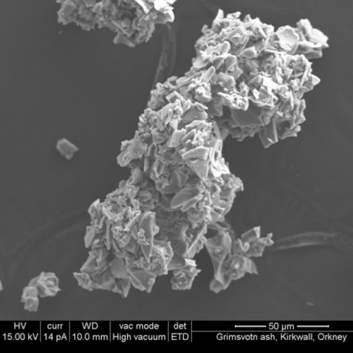
These images show that the magma was fragmented by two explosive processes: bursting of gas bubbles in the magma and interaction with water (rapid expansion of steam). The images and descriptions of ash grains are from samples sent from Kirkwall Grammar School in Orkney.
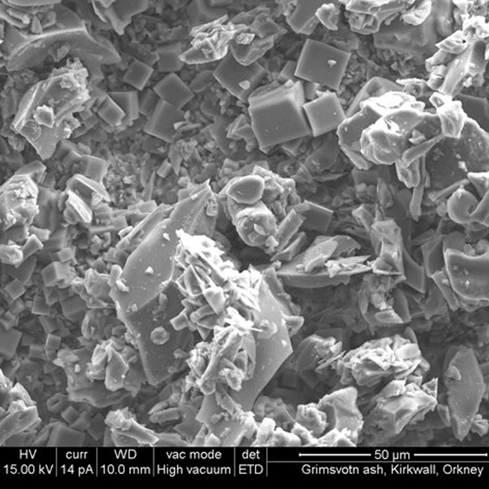

A large aggregate showing abundant cubic halite crystals and angular glass shards. Halite (sodium chloride, or salt) is a late-stage ‘glue’ probably formed as the ash grains come into contact with sea spray in the atmosphere. Samples sent by Kirkwall Grammar School in Orkney. BGS © UKRI.
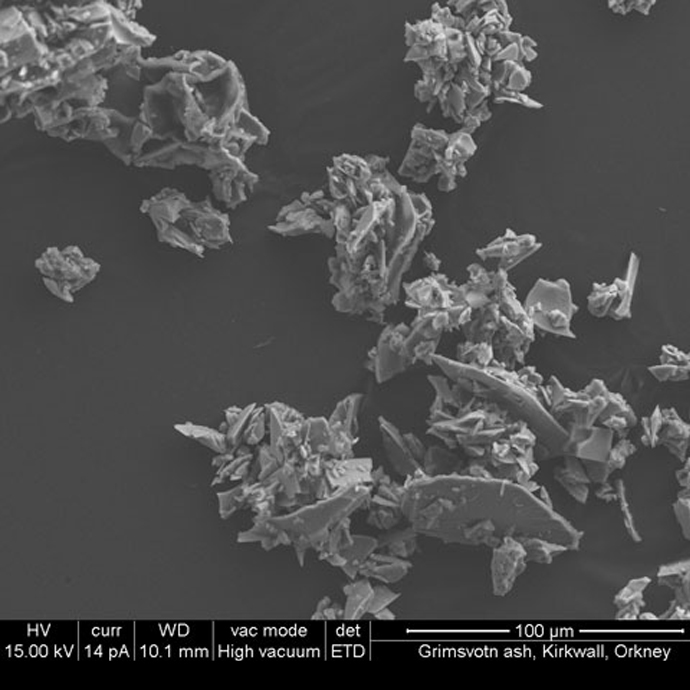
Aggregates of angular, plate-like and curvi-planar glass shards (fragments of magma that cooled quickly) with smaller particles stuck to surfaces. Samples sent by Kirkwall Grammar School in Orkney. BGS © UKRI.
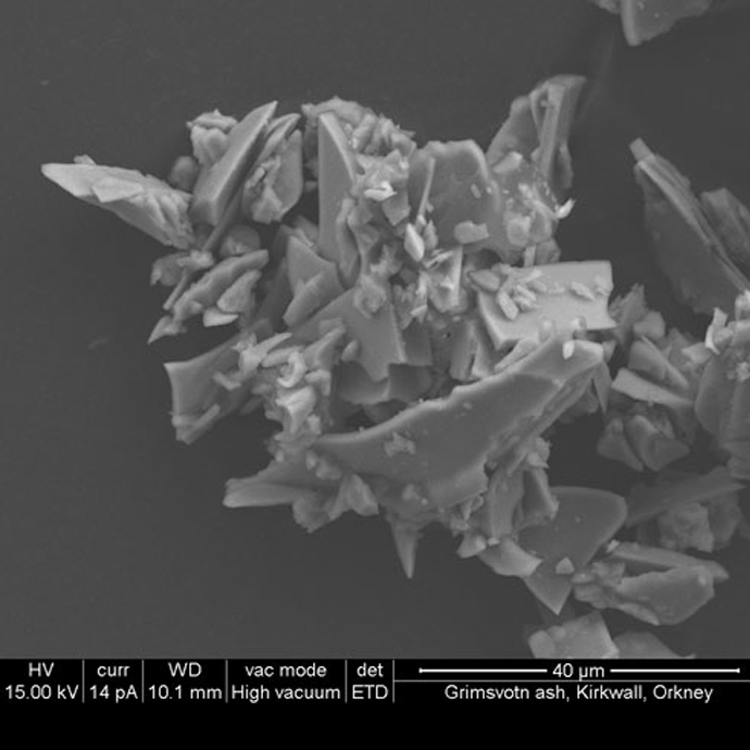
An aggregate of very sharp, angular, plate-like and crescent-shaped glass shards. Samples sent by Kirkwall Grammar School in Orkney. BGS © UKRI.
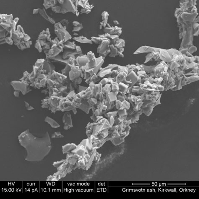
Loose, dendritic aggregate of platy and angular glass shards partly cemented together by cubic crystals of halite. Samples sent by Kirkwall Grammar School in Orkney. BGS © UKRI.
An aggregate of sharp, angular, plate-like and crescent-shaped glass shards. Samples sent by Kirkwall Grammar School in Orkney. BGS © UKRI.
Contact
Contact Julia Crummy, Katy Mee or Sue Loughlin for more information on collecting observations and volcanic ash samples.
You may also be interested in
Volcanology
Our scientists lead research projects and work in partnerships around the world to improve our understanding of volcanic processes, hazards and risks.

Citizen science
Allowing scientists to accomplish research objectives more readily than would otherwise be possible, using volunteers to perform research-related tasks.