
Radon potential. BGS © UKRI.
Radon potential
- 1:50 000
- Great Britain and Northern Ireland
- Premium
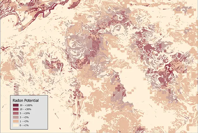
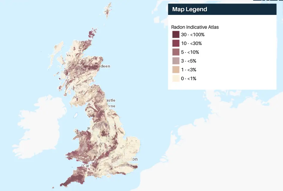
The radon potential dataset is the definitive map of radon-affected areas in Great Britain and Northern Ireland, created jointly by UK Health Security Agency (UKHSA) and the BGS. We used long-term radon measurements, made in over 479 000 homes across Great Britain and 23 000 homes across Northern Ireland (without affecting householders’ confidentiality), combined with geological map data.
Supporting documents:
Key information
- Scale:
- 1:50 000
- Coverage:
- Great Britain and Northern Ireland
- Availability:
- Premium
- Price:
£0.35 per km2. Subject to number of users, licence fee and data preparation fee.
- Format:
- GIS polygon data. (ESRI, MapInfo, other available by request)
- Uses:
- Local-level to regional-level use
- Themes:
- Built environment, Hazards
In collaboration with the UK Health Security Agency (UKHSA), BGS released a significant update to the ‘Indicative Atlas for Radon in Great Britain’ and its underpinning data-product ‘Radon Potential for Great Britain’ on 1 December 2022. If you would like more information about this update please contact our digital data team (digitaldata@bgs.ac.uk).
The radon potential dataset is the definitive map of radon-affected areas in Great Britain and Northern Ireland, created jointly by UK Health Security Agency (UKHSA) and the BGS. We used long-term radon measurements, made in over 479 000 homes across Great Britain and 23 000 homes across Northern Ireland (without affecting householders’ confidentiality), combined with geological map data.
Radon potential dataset coverage. BGS © UKRI – Contains OS data © Crown copyright 2020.
UKHSA recommends that radon levels should be reduced in homes where the annual average is at or above 200 becquerels per cubic metre (200 Bq/m3) — this is known as the ‘radon action level’.
UKHSA defines radon affected areas as ‘those with one per cent chance or more of a house having a radon concentration at or above the radon action level of 200 Bq/m3‘.
The radon potential dataset answers these questions:
- Is a property in a radon affected area?
- What level of radon protective measures do I need to install if I am building a new building or an extension to an existing building?
You may also be interested in

Indicative Atlas of Radon
Radon is a natural radioactive gas, which enters buildings from the ground. Exposure to high concentrations increases the risk of lung cancer.