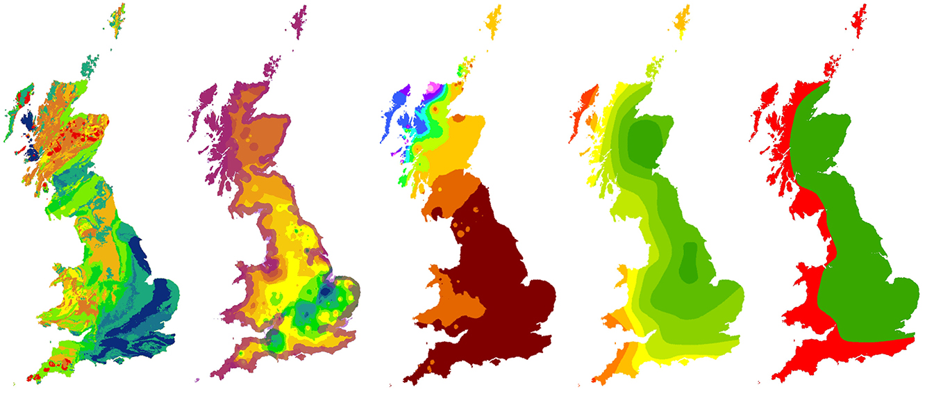

Biosphere Isotope Domains GB (Version 2) showing (from left to right) strontium, sulfur, lead, oxygen (drinking water) and oxygen (human tooth enamel) domains. BGS © UKRI – Contains OS data © Crown copyright 2023.
Biosphere isotope domains (Great Britain)
- The dataset is represented by 1 km hexagon cells
- Great Britain
- Open
The Biosphere Isotope Domains GB (Version 2) data comprises analysis and location-specific information for strontium, sulfur, lead and oxygen (from drinking water and tooth enamel) isotope variation for Great Britain.
Key information
- Scale:
- The dataset is represented by 1 km hexagon cells
- Coverage:
- Great Britain
- Availability:
- Open
- Price:
Free grid data available under the Open Government Licence. Please acknowledge the material.
- Format:
- Excel data, GIS polygon data, and online map viewer.
- Uses:
- Regional-level to National-level use
- Themes:
- Geochemistry, Soils and landscapes
The dataset consists of four components:
- GIS dataset showing the distribution of five domains across Great Britain (strontium, sulfur, lead, oxygen (groundwater) and oxygen (tooth enamel)
- Excel data containing sample information for strontium, sulfur and lead, used in creating the domain maps
- An accompanying web portal for viewing and interrogating the GIS data
- High resolution (300 dpi) maps in JPEG format for all isotope domains
This dataset brings together:
- The oxygen isotope groundwater map published by Darling et al. (2003).
- An update to the strontium layer of the biosphere isotope map published by Evans et al. (2018).
- A new sulfur dataset for plants in Great Britain.
- The oxygen isotope composition of human tooth enamel based on Evans et al. (2012).
- Lead isotope data from mineral deposits across Great Britain, predominantly from Blichertoft et al. (2016).
These five layers can be interrogated to produce a distribution map of the different isotope compositions that can be found across Great Britain. Specifically, it contains:
- Biosphere strontium (87Sr/86Sr): strontium isotope variation derived from c.1300 strontium samples, predominantly from plants and water
- Sulfur δ34S ‰ (VCDT) variation from c.500 modern plants samples.
- Contoured lead isotope variations across Great Britain based on c.600 mineral analyses.
- Oxygen δ18O ‰ (human enamel): oxygen isotope variations in tooth enamel given as the mean and 1SD of ‘local’ populations.
- Oxygen δ18O drinking water ‰ (VSMOW): oxygen isotope variations in groundwater across Great Britain.
This resource is aimed at archaeologists using skeletal analysis to study the geographic origins, movements and diet of past people and populations. The data can also be used in modern studies of bird and fish migration, tracking sources of illegal importation of materials and authentication of food origins.
Biosphere isotope domains – video guide


Biosphere Isotope Domains: How to use the website
