Borehole scans

Scanned borehole record Borehole logging

Free search of over a million borehole records.

The BGS Borehole record viewer offers direct, online access to the National Geoscience Data Centre collection of onshore scanned boreholes, shafts and well records.
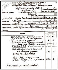
By clicking on the search button below you accept the Terms and conditions of using this service.

What is a borehole record?  A record of boreholes, shafts and wells from all forms of drilling and site investigation work. Boreholes range from one metre to several thousand metres deep.

Borehole records are produced from a geologist's or surveyor's observations of the rock core extracted from the ground. It typically includes locality, lithological descriptions with depth and thickness.

Other on-site measurements that may be noted are:

  • geophysical logs

Abbreviations used in borehole/water well records 124 KB pdf

See also What is a borehole? 400 KB pdf

National well archive   Searching BGS borehole records also gives you access to the the National Well Record Collection. It contains more than 130 000 classified records of wells, boreholes and springs within England and Wales; a unique database of hydrogeological information.

On-site measurements that may be noted are:

  • water level measurements
  • geochemistry data

GeoRecords Plus+

Operating a borehole drilling rig

For more detail use the GeoRecords Plus+ service.

The GeoRecords Plus+ Team will check, prepare and supply your selected borehole record as a pdf document.

Free with GeoRecords Plus+— a borehole data pack containing:

  • geological map extract
  • data listing of your site selection

Download an example Borehole Data Pack 1.8 MB pdf

Download the GeoRecords Plus+ borehole ordering User Guide 400 KB pdf

GeoIndex

Borehole record scans can also be obtained via GeoIndex, our map-based index that allows users to search for information about BGS data collections.