Between 14 September and 7 October 2016, the BGS contributed to an advisory mission in Solotvyno, Ukraine, for the European Union Civil Protection Mechanism (EUCPT). The mission was undertaken in response to a cross-border (Ukraine/Romania) environmental pollution incident and was commissioned by the Director General of the Directorate-General of European Civil Protection and Humanitarian Aid Operations (DG ECHO).
It was suspected that the cross-border environmental pollution was linked to the Solotvyno salt mine complex. The mission was to generate a ‘comprehensive risk assessment at the Solotvyno salt mines area’, requiring a focus on the stability of the workings and the potential impact on the River Tisza, a major tributary of the Danube. It comprised 16 experts from eight countries and included five of the experts from the original scoping mission in July, 2016.
The legacy of the mines was evident in all aspects of Solotyvno life with significant implications for humanity, civil engineering and socio-economics, including consideration of the economic value of the salt to the region, the political complexity and the Tisza as a major tributary of the Danube.
Mining history
The Solotvyno mine in the Zakarpatye province of Ukraine was the first (former) Russian rock-salt mine (Logunov, 1997). It is situated in a southerly looping meander of the River Tisza, which forms the border between Ukraine and Romania. Six medieval mines were worked to a relatively shallow depth and collapse of these mines led to the formation of the saline ponds that lie at the heart of the current tourist industry. Three deeper mines were commissioned between 1809 and 1975 and they extended to depths of up to 430 m.
The mines were constructed as a series of tall (up to 65 m high) chambers, in the order of 12–20 m wide, at a number of levels. Mine 7 closed in 1953 after the collapse of one of the support pillars, whereas Mine 8 and Mine 9 were closed because of flooding. Mine 7 was artificially flooded, resulting in the formation of more than 50 sinkholes of up to 20 m diameter and up to 40 m deep. The largest of the sinkholes is in the order of 200 m in diameter.
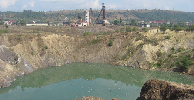

Sinkhole associated with Mine 7, with mining infrastructure in the background. BGS © UKRI.
The abandoned mines were left to flood because, when filled with saturated brine, the potential for further dissolution and therefore the risk of further collapse is minimised. During the mission the International EUCPT collected data on the mines and their history, undertook a surface and groundwater survey and visually assesed the integrity of infrastructure.
Tourism
The modern tourist industry grew up based on the health benefits of brine pools. Until September 2008, Solotvyno advertised itself as a medical resort with an allergological hospital using the former mines for speleotherapy therapies at depths up to 300 m below ground level.
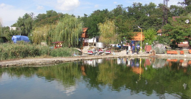
Collapsed medieval mines as a tourist attraction. BGS © UKRI.
Geology
The Miocene (23 to 5 million years ago) salt deposits of Solotvyno occur in the fault-bounded Solotvyno depression of the Ukranian Carpathians. They comprise a fault-bound, 2000 m-long salt diapir (salt dome) that is elongate in shape and lies along a north-west to south-east alignment. The Miocene sedimentary sequence consists of sandstones and siltstones interbedded with volcanic tuffs, resting on igneous and metamorphic rocks of the Ukrainian Precambrian shield. The rock salt is predominantly white in colour, with grey layers of clays with subordinate gypsum anhydrites (Hryniv et al., 2007). The salt has recrystallised as flow-textured halite due to metamorphism.
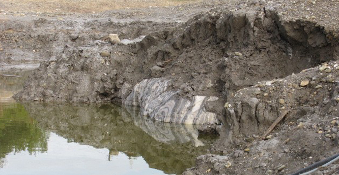
Residual clays capping the salt in the flooded abandoned medieval mines. BGS © UKRI.
The presence of the impurities gives rise to characteristic karst processes (both void and sinkhole development) operating in the salt. Where undisturbed, the clay-rich salt residue forms a naturally protective layer, locally referred to as palag or pallah, and the different forms of crystallisation influence the geomechanical properties of the salt. River terrace deposits provide evidence of Neogene (23 to 2.5 million years ago) uplift and cover the surface of the salt dome. The engineering properties of the overlying sediments (high permeability) is influential in naturally occurring salt karst.
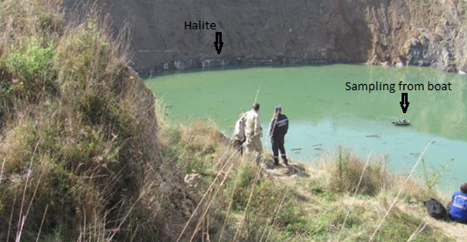
Sinkhole water sampling. BGS © UKRI.
Conceptual model development
Scientists focused on the development of a conceptual ground model as the basis of a risk assessment. Many different types of data were collected, including:
- Hydrogeological data: comprising surface and groundwater sampling, with on-site measurements (electrophysical and GPS) supplemented with isotope analyses carried out by BRG (Germany) and basic chemical analyses. This data was collected to further understanding of the hydrology of the River Tisza, the baseline hydrogeology, the mining hydrology and karst processes. Water sampling in the sinkholes was undertaken in collaboration with Ukraine State Rescue Service (Mountain Rescue).
- Geological data: collected from the literature and supplemented by presentations and discussions with academics from the National Academy of Sciences.
- Building condition structural surveys: used to assess the extent of mining effects.
- Socio-economic data: collected through a series of interviews at the state, regional, district and local level.
- Mining data: obtained through liaison officer/team leader negotiation with the mine engineers and municipal administrative bodies.
Fieldwork
Fieldwork was monitored and facilitated by the EUCPT technical staff and Ukrainian colleagues from the National Academy of Sciences. Impact assessment was challenging in the context of anthropogenic activities, such as poor land-management practices, e.g. pipe discharges to the sinkholes and destruction of the palag cover, with the potential to exacerbate the natural processes that have resulted in a deterioration of the mines and surrounding area.
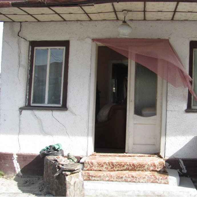
Ground stability impact on construction. BGS © UKRI.
Risk assessment
Risk assessment was undertaken using ‘Bowtie’ techniques comprising a diagrammatic capture of risk flow thought processes in terms of causes–risk–consequences. These diagrams enabled an assessment of risk criticality in terms of the land-stability risk to the local population and potential environmental impact on the Tisza.
Impact
In response to the report, the Directorate General for European Civil Protection and Humanitarian Aid Operations (DG ECHO) has provided grant funding for the project ‘Improving disaster risk reduction in Transcarpathian region’ (ImProDIRet), aimed at strengthening how communities, government, and other relevant stakeholders jointly manage the risks in the Transcarpathian region, with particular attention to the Solotvyno salt mines. This project extended the work by:
- undertaking further risk assessment
- generating risk maps for Solotvyno and the broader Transcarpathia region
- creating a disaster risk reduction platform for Transcarpathia
- carrying out community safety surveys and risk awareness campaigns with children
- creating an awareness and disaster information app
- broadly agreeing a roadmap for Solotvyno
Acknowledgements
This research was collaborative it was undertaken through the European Union Civil Protection Mechanism with the support of Ukrainian technical experts from the National Academy of Science (NAS) of Ukraine, the Solotvyno Mine authorities, and Ukraine State Rescue Service (Mountain Rescue).
References
, S P, , B V, , O V, and
Logunov, E V. 1997. A history of salt production in Russia. Science Tribune, January 1997.
Stoeck, L, Banks, V, Shekhunovac, S, and Yakovlevc, Y. 2020. The hydrogeological situation after salt-mine collapses at Solotvyno, Ukraine. Journal of Hyrdology: Regional Sudies, Vol. 30, 100701.
You may also be interested in
Sinkholes and karst research
Our research extends beyond the distribution and processes associated with sinkhole formation to the broader subject of karst.