Download our 3D geology models as Minecraft worlds and learn how geology can influence the landscape.
We have built five worlds to allow you to explore underground and learn about the geology. Four of these worlds show small sites around the UK and use real geological data to show what the geology looks like under the surface. The fifth world shows a simplified geology of the whole of mainland Great Britain. These models show how geology can influence landscapes and land use, and can help teach geology to a younger audience.
At the end of section, there is also a user-generated volcano world created by three students from Nottingham.
- Getting started: requirements and installation
- How did we make the BGS Minecraft worlds?

Once downloaded, save the BGS_GB_Geology world into your resources folder. Watch this animation for additional help. BGS ©UKRI .
Getting started: requirements and installation
To start you off on your Minecraft journey we have built a spawn point, which includes some information about the blocks and which real world geology they represent. You can use this to learn more about the geology of the area by spawning back to the platform at any point.
- a licenced copy of Minecraft
- 50 MB free disk space per local area world
- 6 GB for the Great Britain world
- more than 4 GB of RAM
- Download the 3D model as a zip file archive (between 1 and 65 MB).
- Unzip the archive to a temporary location.
- Start Minecraft.
- On the home screen, click ‘Options’.
- Click ‘Resource Packs’.
- Click ‘Open resource pack folder’. This will open a new window showing the contents of your Minecraft ‘Resource Packs’ folder.
- Navigate to the folder (called .minecraft on Windows).
- Open the ‘saves’ folder.
- Move the unzipped archive to this ‘saves’ folder.
How did we make the BGS Minecraft worlds?
We decided to use glass blocks that were coloured by traditional geology map colours. This allows you to dig into the model and ‘fall’ between each geological layer. You can then explore under the ground in Minecraft because the glass blocks allow you to see through them. When experimenting with these 3D Minecraft worlds we discovered that, by using glass blocks, the player could see the true extent of the geology straight away.
What data did we use?
To build each of these models we used a number of different datasets, including:
- 3D geology — geological surfaces taken from BGS 3D models
- elevation — taken from the surface of the 3D geology models
- topography — OS VectorMap District
The worlds
- Glasgow Minecraft world
- Ingleborough Minecraft world
- York Minecraft world
- West Thurrock Minecraft world
- Great Britain Minecraft world
- Volcano Minecraft world
Glasgow Minecraft world
The geology in this world is in two parts. The first has the shallower rocks and soils directly underneath Glasgow, called ‘superficial geology’. We have also included artificial ground in this world.
The second, lower part, is called the ‘bedrock geology’ (this is the hard rock, not what Minecraft calls Bedrock) and these rocks date from the Carboniferous Period, including the Upper Coal Measures.
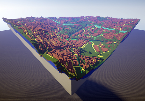
Minecraft world of the centre of Glasgow. BGS © UKRI.
When you first land in the world, there will be signposts with information to get you started. Once you’ve got your bearings you can fly around the 3D world by double tapping then holding the space bar, which will cause you to fly up into the air. This world includes the topography (features on the ground such as roads and buildings) that will help you to find your way around the world.
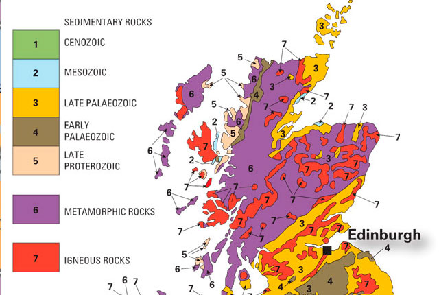
Geology key
The geological units for each world have been grouped together in order to accommodate the limited Minecraft glass block palette of 16 colours. Where possible, we have tried to emulate the BGS geological unit colours.
This Glasgow Minecraft world is based on the BGS central Glasgow 3D geological model. The geological model gives engineers and construction companies a subsurface view of the geology underneath Glasgow to help save time and money during construction projects. It also provides insight into the potential for geothermal heat from the water found in flooded mine workings — see UK Geoenergy Observatories Glasgow.
Covering about 100 km2, the area shows the superficial deposits of the central Glasgow area, including glaciated material from successive ice sheets. The model was built within BGS’s GOCAD® and GSI3D software, using a digital elevation model of 20 m cell resolution, and is based on datasets held by BGS, such as digital maps and boreholes.
The superficial deposits in the Minecraft world are mostly glacial tills, reflecting the advances and retreats of ice sheets. The tills often rest directly on bedrock geology and comprise a mixture of clay, sand and silt with pebbles, cobbles and boulders.
Other types of superficial deposits in the area are related to several marine inundations (raising and lowering of the sea level) during and since the last glaciation, the development of river terraces, the deposition of estuary sediments, and local lakes, some infilled partly by peat.
The bedrock geology in the Minecraft world dates back to the Carboniferous Period (485–541 million years ago). The majority of the rocks were deposited in an environment such as a river delta or a shallow sea and consist of sandstone, coal and limestone. The rocks were identified using borehole material and descriptions from borehole drill wells and using things found in the rock, such as fossils and minerals, to give the rocks an age.
Ingleborough Minecraft world
This Minecraft world uses the classic geological study area of Ingleborough, Yorkshire Dales, as an introduction to 3D geological models. This world is modelled at 1:250 000 scale and covers an area of 18 km2. You can fly over the landscape at the surface or dig below ground to expose some of the limestone landscape beneath Ingleborough.
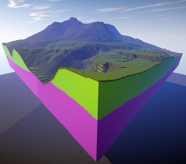
Minecraft world of the classic geological study area of Ingleborough. BGS © UKRI.
When you first land in the world there will be signposts with information to get you started. Once you’ve got your bearings, you can fly around the 3D world by double tapping then holding the space bar, which will cause you to fly up into the air. This world includes the topography (map features on the ground such as roads and buildings) that will help you to find your way around the world.
Geology key
The geological units for this world have been grouped together in order to accommodate the limited Minecraft glass block palette of 16 colours. Where possible, we have tried to emulate the BGS geological unit colour.
The geological model was built by BGS in 2010 using GSI3D and is calculated using a digital elevation model (DEM) with a 5 m grid spacing, it extends to about 100 m OD.
The Minecraft world contains three areas of worked ground, one in the Great Scar Limestone Group in the north and two in the Ingleton Group in the main valley. The world contains three superficial rock units; alluvium from the rivers Doe, Kingsdale and Ribble, peat on the flanks of Ingleborough and till in the south-west and north-east.
The till has been modelled in areas of drumlin development to accentuate the landforms. Till is present elsewhere in the area, but is not displayed in the world. The till in this region was laid down by the Devensian ice sheet, which covered the whole region.
The bedrock geology is made up of several layers. The youngest late Carboniferous deposits of the Pennine Lower Coal Measures Formation comprise interbedded sandstones, siltstones and mudstones with several coal seams. The early Carboniferous limestones of the Great Scar Limestone and Yoredale groups contain classic karst features such as Gaping Gill. The limestone is up to 500 m thick.
In the south-west, the Dent Formation, of Ordovician age (444–485 million years ago) and comprised of shallow marine sediments, limestone and pyroclastic rocks is encountered south of the North Craven Fault. Most of the area is unconformably underlain by the Ordovician Ingleton Group of sandstones, siltstones and conglomerates, which is over 300 m thick.
Download Ingleborough world
York Minecraft world
This Minecraft world covers 50 km2 of terrain to the north and east of York including in the north the village of Haxby. The area lies within the low lying Vale of York where deposits from the last glaciation (Devensian) often rest directly on the Triassic bedrock.
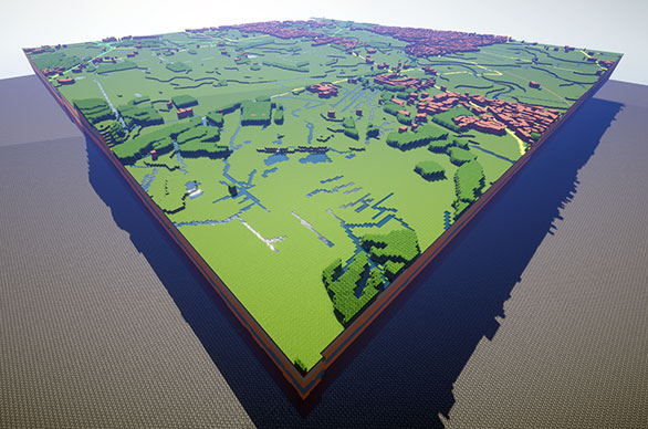
Minecraft world of 50 km2 of terrain to the north and east of York. BGS © UKRI.
When you first land in the world there will be signposts with information to get you started. Once you’ve got your bearings you can fly around the 3D world by double tapping then holding the space bar, which will cause you to fly up into the air. This world includes the topography (map features on the ground, such as roads and buildings) which will help you to find your way around the world.
Geology key
The geological units for each world have been grouped together in order to accommodate the limited Minecraft glass block palette of 16 colours. Where possible we have tried to emulate the BGS geological unit colours.
The York model was built by BGS in 2005 as a result of a geological survey and model building programme for the Selby and York areas. The rocks were identified using borehole material and descriptions from borehole drill wells and using things found in the rock, such as fossils and minerals, to give the rocks an age.
The model extends to about 50 m depth and has been calculated using a digital elevation model (DEM). At high vertical exaggerations, despite processing, some residual effects, mainly due to local woodland, can still be seen in the top model surface.
The world shows the large flat areas of alluvium of the River Ouse in the extreme south-west and its tributary the Foss.
The Vale of York Till forms the core of the York Moraine, which is a low ridge near the southern end of the world. During the glaciation, meltwater became ponded at several times in the Vale of York due to ice blocking drainage via the Humber into the North Sea Basin and beyond.
The bedrock in the area is Triassic Sherwood Sandstone, which is a significant aquifer in the Vale of York.
Download York world
West Thurrock Minecraft world
The West Thurrock world covers about 10 km2 along the eastern flank of the M25 motorway on the north bank of the River Thames. It depicts an extensively modified and developed landscape with several extensive areas of artificial ground, including the building of the Lakeside shopping complex within an old chalk quarry.
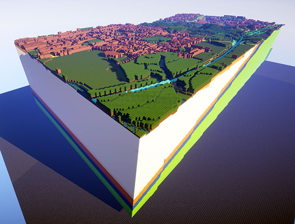
Minecraft world of West Thurrock showing the M25 motorway, east of London, on the north bank of the River Thames. BGS © UKRI.
When you first land in the world there will be signposts with information to get you started. Once you’ve got your bearings you can fly around the 3D world by double tapping then holding the space bar, which will cause you to fly up into the air. This world includes the topography (map features on the ground, such as roads and buildings) that will help you to find your way around the world.
Geology key
The geological units for each world have been grouped together in order to accommodate the limited Minecraft glass block palette of 16 colours. Where possible, we have tried to emulate the BGS geological unit colours.
The original geological model was built in 2009 in GSI3D. It shows a developed landscape with several extensive areas of artificial ground, including the building of the Lakeside shopping complex within an old chalk quarry.
The southern part of the world occupies the River Thames’s floodplain. Here, interbedded alluvial silts, clays and peats overlie gravel deposits. Together, these sediments are up to 15 m in thickness. Older river terrace deposits comprising sands and gravels fringe the alluvium and are preserved as erosional remnants farther north.
The bedrock geology is dominated by chalk, which underlies the whole area with the world extending to a depth of about 150 m. In the northern portion of the world, younger bedrock units are, in ascending order, the Thanet Sand, Lambeth, Harwich and London Clay formations.
Download West Thurrock world
Great Britain world
BGS has also developed a Minecraft world devoted to the geology of the whole of mainland Great Britain. This world shows an interpretation of the Ordnance Survey open map data on the surface and the rough position of the real geology beneath.
You will start at the BGS office in Cardiff. Look around you for signposts with information to get you started. Once you’ve got your bearings you can fly around the landscape by double tapping and holding the spacebar.
This Minecraft world uses the BGS Soil Parent Material Map to describe the geology across the whole of mainland Great Britain. The country was divided into smaller chunks (100 × 100km grid squares) so that Minecraft could cope with the whole area.
For each 100 × 100km square we:
- loaded the height of the land surface from an elevation of Great Britain, using a modified and scaled version of NEXTMap Britain data
- loaded the geology from the Soil Parent Material Map
- loaded the OS VectorMap® District raster files
- for each chunk we used the height data to add blocks repeatedly up to the specified height and using the real world geology for that location
- for the topmost block, we decided which material best matched the OS VectorMap® District data
- finally, we compiled groups of 32×32 chunks into regions, and then compiled the whole lot into one zip file
The Minecraft GB geology world represents the geology at the surface, but that geology does not change as you dig down into the world, as BGS doesn’t have 3D data covering the whole of the UK. It’s important to know that this is why the GB geology world is different to the larger scale models described above, which do have 3D geology included.
To do this, we have used BGS’s Soil Parent Material dataset. A parent material is a soil science name for a weathered rock or deposit from, and within which, a soil has formed. In the UK, parent materials provide the basic foundations and building blocks of the soil, influencing their texture, structure, drainage and chemistry. By using the parent material dataset we can get a general understanding of the types of geology to be found across Great Britain.
Using the methodology developed by the Ordnance Survey, we took the data from the OS VectorMap® District raster to decide the material of each block.
Volcano Minecraft world
This Minecraft world was created by three students from Nottingham. Created during summer 2020 during the COVID-19 lockdown, this volcano model was produced as a result of a short collaboration between BGS geospatial data staff and students from a local secondary school.
The volcano world includes a magma chamber, moving ‘redstone’ magma and side vents. At the surface, the world shows a farming village that benefits from the fertile volcanic soil that surrounds many volcanoes.
When you first land in the world there will be signposts with information to get you started. Once you’ve got your bearings you can fly around the 3D world by double tapping then holding the space bar, which will cause you to fly up into the air.
Download volcano world
Acknowledgements
- Minecraft is ©2009 – 2015 Mojang AB.
- Models built using Safe Software’s FME 2015.
- Contains Ordnance Survey data © Crown copyright and database right 2015.
You may also be interested in
Discovering Geology
Discovering Geology introduces a range of geoscience topics to school-age students and learners of all ages.
Maps and resources
Download and print free educational resources.