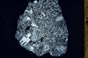
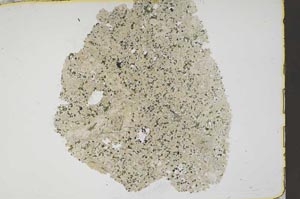
BGS mineralogy and petrology collection record
| Sample number | S44066; COLLNOXP219; |
|---|---|
| Sample Donor | Read,W.A. |
| Rock name | Not entered |
| Stratigraphy | Not entered |
| Comments | Sill, in Lower SedimentaryGroup of Calciferous Sandstone Series |
| Locality details | 2300 ft at 233 deg from Scout Head summit; near base of 40 ft crag, on S side of knoll, W of Meiklewood - Forestry Commission march |
| 50k map sheet | Stirling (39) |
| Map reference | NS 7203 9341 |
| Year collected | Not entered |
| Bore name | Not applicable |
| Confidentiality | No restrictions |
Petrological thin sections
Links to high resolution images
Transition from XPL to PPL light
S44066