
The Environment Agency has designated 11 principal aquifers in England and Wales. These are listed below, with the youngest aquifers at the top and the oldest at the bottom of the list.
Click on any of the named principal aquifers in the list to see a thumbnail map of the distribution that aquifer. Once you have selected the aquifer that you are interested in, click on the map or follow the link below the map for information about the geology and hydrogeology of the aquifer and to see a more detailed map of the distribution of the aquifer.
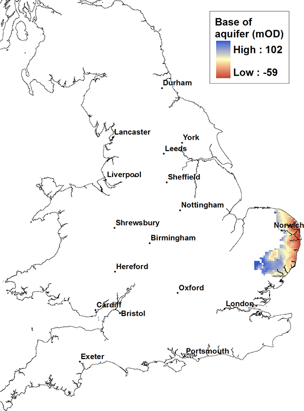

Crag aquifer map. BGS © UKRI.
The Crag
The Crag is a locally important aquifer, up to about 80 m thick, found in parts of East Anglia. It generally consists of unconsolidated marine sands that may be locally hard and consolidated. The Crag may form a single groundwater-bearing unit where it is connected to overlying glacial sands. The yield is typically moderate to low, of the order of 10 l/sec. Water quality can be poor, iron-rich and hard, particularly below a cover of boulder clay (a Quaternary glacial clay deposit). Seawater intrusion may occur in to the Crag near the coast.
Crag in the BGS lexicon of named rock units.
Area where the Crag is present
The Crag is present in central, southern and eastern East Anglia.
Elevation of base of the Crag
At its western extent the base of the Crag is at about 100 m above OD and dips gently to the east, but at its deepest on the coast of East Anglia it is only at about 50 or 60 m below OD.
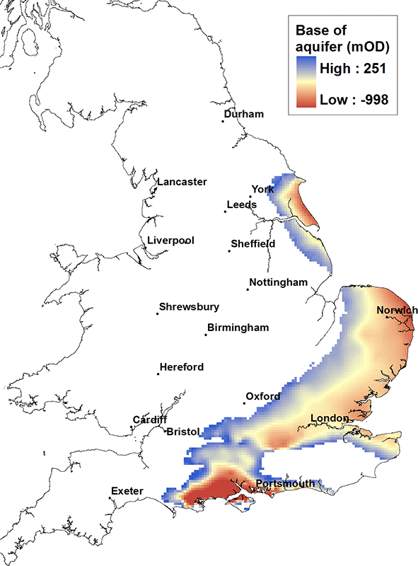
Chalk aquifer map. BGS © UKRI.
The Chalk
The Chalk is the major aquifer of southern and eastern England. It is a microporous white limestone with low matrix permeability. It is an aquifer due to its well developed interconnected network of fractures. Yields (typically of the order of 150 l/sec) are highest where the density of fractures is greatest and/or where the fractures are enlarged (sub-karst) typically in the top 80 to 100 metres of the aquifer.
Porewater found at depth in the aquifer may be saline, particularly where the Chalk is confined by Palaeogene and Quaternary deposits in the Thames Basin and across East Anglia. The Chalk is prone to diffuse pollution from nitrate and pesticides associated with agricultural activity at the land surface and more locally by point source pollution, for example from leakage or spillage of industrial chemicals and petroleum hydrocarbons.
BGS has published a number of regional memoirs on the Chalk aquifer, as well as an online memoir for the Thames Basin that includes information on the Chalk in this area.
Chalk in the BGS lexicon of named rock units.
Area where the Crag is present
The Chalk is present in the south east of Yorkshire, southwards across the Humber and into Lincolnshire. It is also present east and south of the Wash in a swathe across central southern England from north Norfolk, through the Thames Basin and along the Kent coast, down to the south coast, the Isle of Wight and into Dorset towards Portland Bill. It is associated with the iconic scenery of the Chalk downlands and the white cliffs in and around Dover.
Elevation of base of the Crag
The Chalk is exposed at the land surface along its western margins and generally dips east and southward. The base of the Chalk unit to the north of the Humber and along the east coast East Anglia is typically at a depth of the order of 500 m below OD, while in the centre of the Wessex Basin near Southampton the base of the Chalk may be in excess of 700 m below OD.
About the aquifer maps
Find out more about how the principal aquifers of England and Wales are defined in the methods section or download the data used to prepare the maps.