
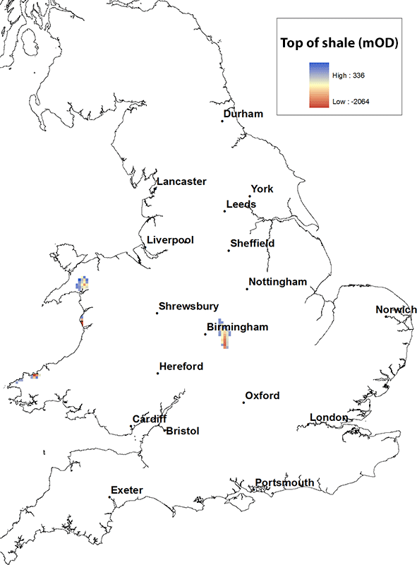
Shale and clay occurrence maps
Maps have been produced for the six major shale or clay units in England and Wales. The distribution of each of these is shown on separate shale and clay maps which include information on the depth to the top of the shale/clay unit. There is also associated interpretive information about each of the shale or clay units.
The maps
Select a shale unit to access a map and further information.
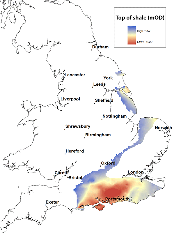
Kimmeridge Clay and Ampthill Clay formations map. BGS © UKRI.
The Kimmeridge Clay Formation consists of black shales with cementstones and oil shales. A report by DECC (now the North Sea Transition Authority) from 2013 states that the Kimmeridge Clay Formation is ‘potentially prospective shale (for oil and probably biogenic gas) because it contains ubiquitous oil shale beds. Its background shale has total organic carbon (TOC) up to about 10 per cent, its bituminous shale has TOC values up to 30 per cent and its oil-shales have TOCs reaching 70 per cent (e.g. the Blackstone Bed).’
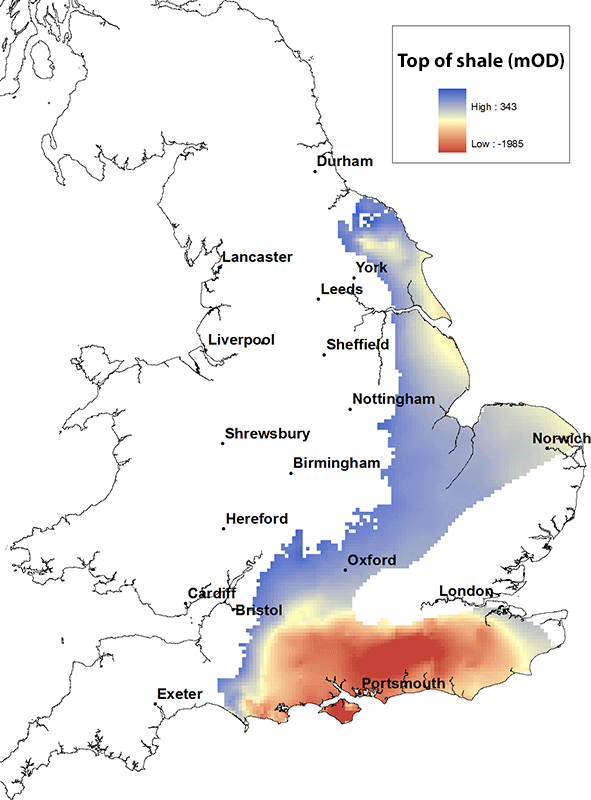
The Kimmeridge Clay Formation is found from the Yorkshire coast in a swathe down the east coast of England to north Norfolk and then running south westward to the east Dorset coast and more extensively eastward through the Wessex Basin and throughout southern England. The Ampthill Clay Formation is present in Oxfordshire and Wiltshire up to Humberside.
The maximum height of the top of the Kimmeridge Clay Formation is about 250 m above OD where it crops out at the western end of the Wessex Basin and is at its deepest, within the centre of the Wessex Basin, it reaches depths of in excess of 1000 m below OD.
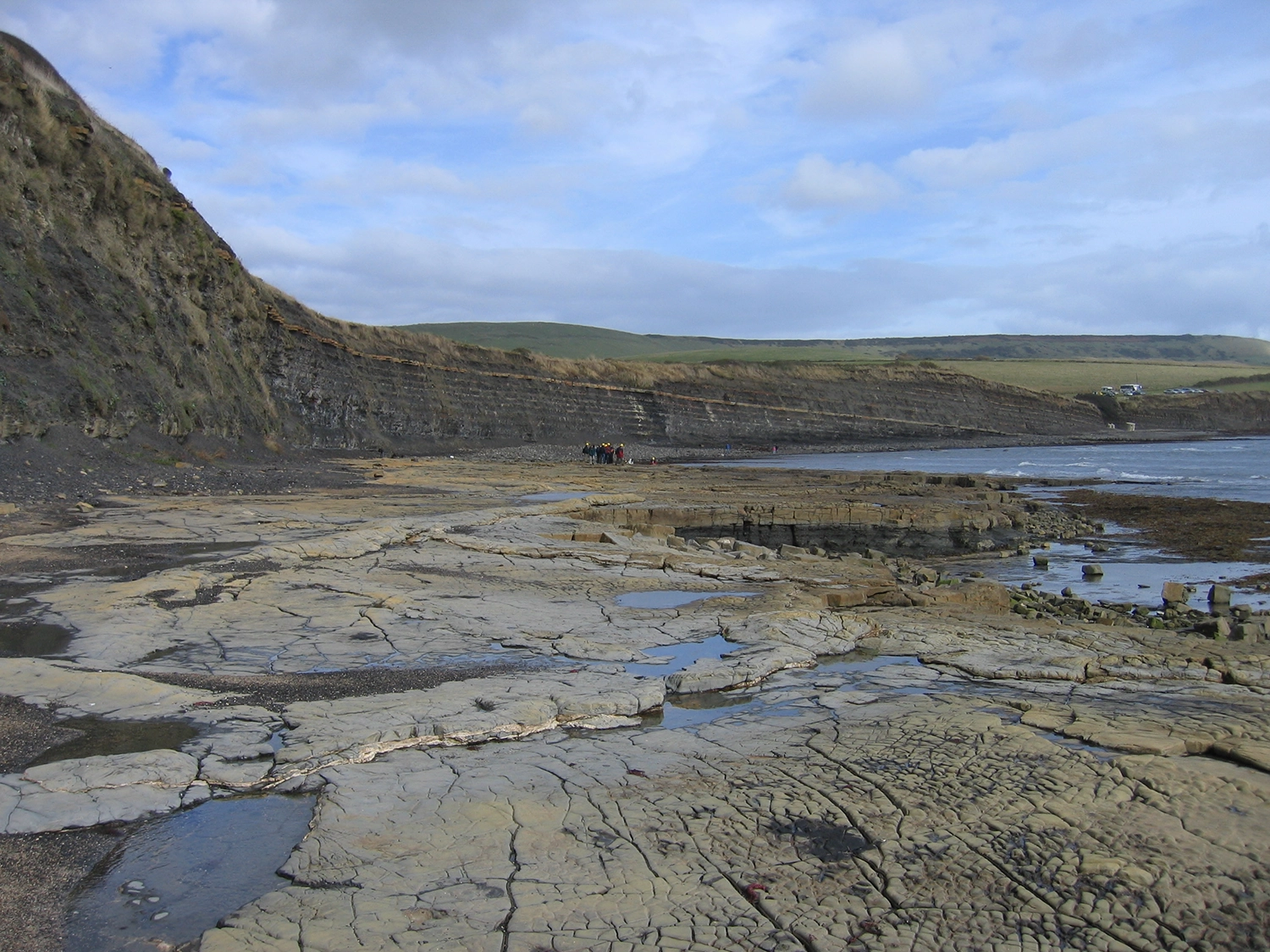
Kimmeridge Bay, Dorset, England is the type area for the Kimmeridge Clay Formation. BGS © UKRI.
Kellaways, Oxford Clay and Osgodby formations shale map. BGS © UKRI.
The Kellaways, Oxford Clay and Osgodby formations are lithologically diverse. They include mudstones, bituminous clays, calcareous siltstones, beds with limestone nodules and local sandstones. For example, where present, the Kellaways Sand Member may yield small, often saline, supplies of groundwater.
A report by DECC (now the North Sea Transition Authority) in 2013 states that the Oxford Clay Formation is ‘immature for hydrocarbon generation in the English Midlands, but […] in the Weald Basin its [total organic carbon] TOC reaches 7.83 per cent and it lies within the oil window at the basin’s depocentre. In southern England and central England there is often a bituminous horizon near the base, but this is absent in Yorkshire. TOCs average below 2 per cent in the non-bituminous sections but are over 4 per cent in most of the bituminous sections of central England, where they are immature for oil.’
The distribution of the Kellaways, Oxford Clay and Osgodby formations is similar to that of the overlying Kimmeridge Clay and Ampthill formations. They are found in a swathe from the Yorkshire coast down to the east coast of England to north Norfolk, through the Wessex Basin and along through southern England.
The maximum height of the top of the Kellaways, Oxford Clay and Osgodby formations is about 300 m above OD. The top of these formations is deepest within the centre of the Wessex Basin, where it reaches depths in excess of 1500 m below OD.
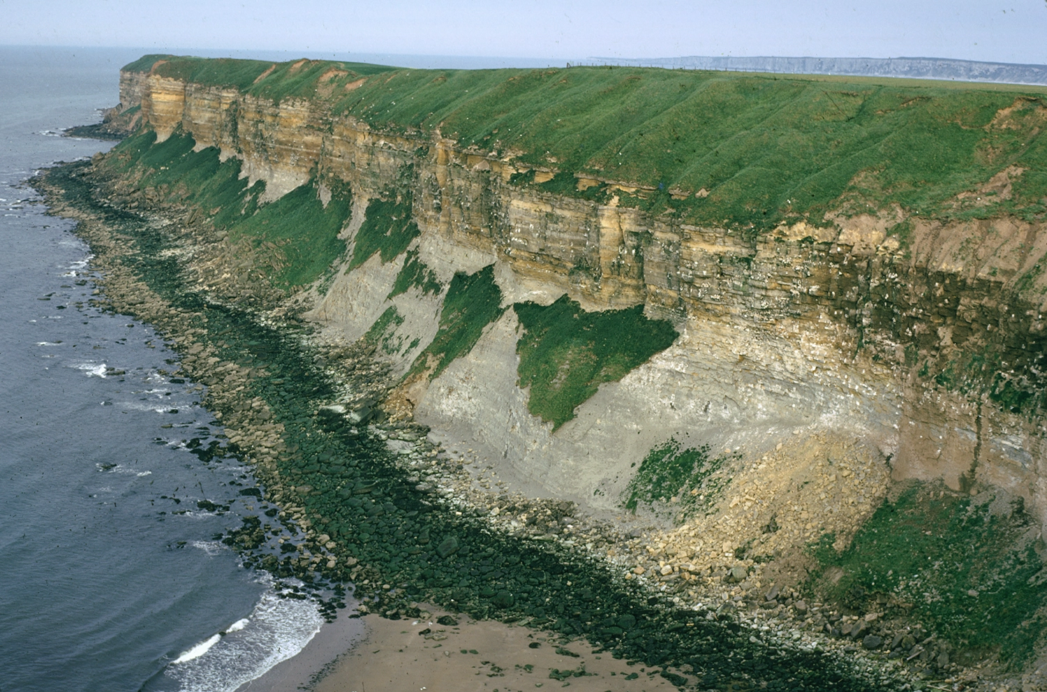
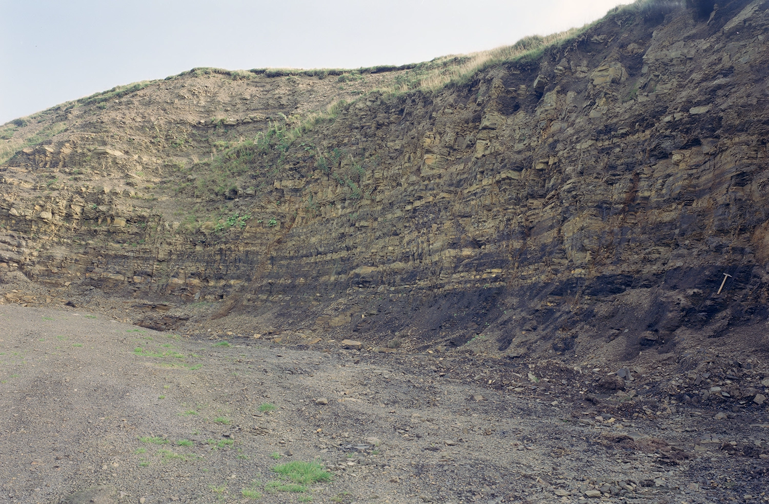
Newbiggin Cliff near Filey, Yorkshire, England. The cliff is composed of Oxford Clay Formation overlain by Corallian Group rocks and glacial till. BGS © UKRI.
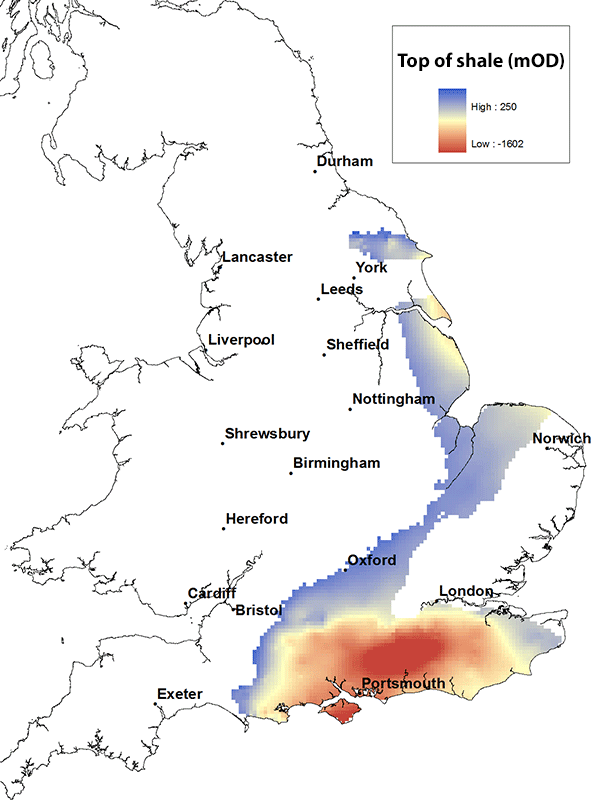
Lias shale map. BGS © UKRI.
The Lias consists of thick mudstones and clays with alternating bands of thin limestones. The fissured Marlstone Rock Formation (formerly the Marlstone Rock Bed) yields small supplies of groundwater in the East Midlands.
A report by DECC (now the North Sea Transition Authority) in 2013 states that the Lias ‘though probably lying in the oil window […] is immature for shale gas […] the Lias is the source rock for the Weald Basin petroleum system and for the Wessex Basin, with migration into three different reservoirs in Wytch Farm oil field.’
The distribution of the Lias is similar to that of the overlying Kimmeridge Clay and Ampthill formations and the Kellaways, Oxford Clay and Osgodby formations. It is present continuously from the Yorkshire coast, along the eastern seaboard of England down to north Norfolk, through central southern England down to Dorset and throughout the Wessex Basin and southern England.
The maximum height of the top of the Lias is about 300 m above OD. It is deepest within the centre of the Wessex Basin, where it reaches depths of almost 2000 m below OD.

Alternating shales and limestones of the Blue Lias Formation at Kilve, Somerset, England. BGS © UKRI.
Marros Group shale map. BGS © UKRI.
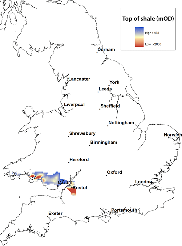
The Marros Group consists of siliceous mudstones and locally quartz rich sandstones and conglomerates. The group is present from Pembrokeshire throughout southern Wales and east of the Bristol Channel.
The maximum height of the top of the Marros Group is about 400 m above OD at outcrop in South Wales and is at its deepest in South Wales and to the east of the Bristol Channel, reaching depths of over 2500 m below OD.
Sandstones and mudstones of the Telpyn Point Sandstone Formation of the Marros Group at Nant Pedol, South Wales. BGS © UKRI.
Bowland and Craven shale map. BGS © UKRI.
The Bowland Shale Formation and Craven Group are variably fissile, organic-rich mudstones, with thin limestones and local sandstone, siltstones, cherts and reef limestones.
The Bowland shale gas study states that ‘The organic content of the Bowland-Hodder shales is typically in the range 1 to 3 per cent, but can reach 8 per cent [… and] is a function of burial depth, heat flow and time, but subsequent uplift complicates this analysis. Where they have been buried to sufficient depth for the organic material to generate gas, [… they] have the potential to form a shale gas resource analogous to the producing shale gas provinces of North America. Where the shales have been less-deeply buried, there is potential for a shale oil resource [… and the] shales are considered mature for gas generation at depths greater than c. 2900 m [below ground level]. However, central Britain has experienced a complex tectonic history and the rocks here have been uplifted and partially eroded at least once since Carboniferous times. Because of this, the present-day depth to the top of the gas window is dependent on the amount of uplift, and can occur significantly shallower than 2900 m.’
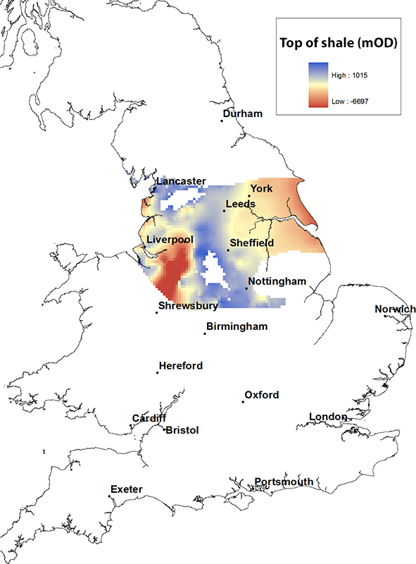
The Bowland and Craven are present throughout northern England, from the Yorkshire and Humberside coasts over to Merseyside and north to the Lancashire coast.
The maximum height of the top of the Bowland and Craven is about 1000 m above OD at outcrop and is at its deepest in the centre of the Cheshire Basin, reaching depths of over 6000 m below OD.
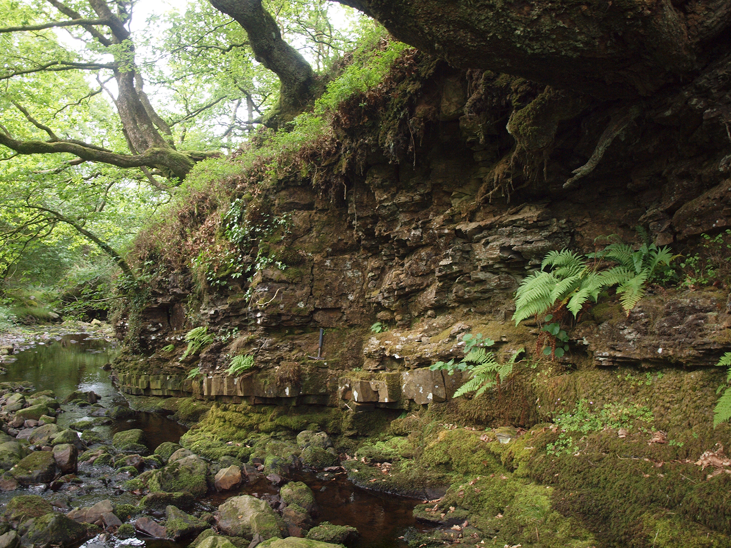
Interbedded mudstones typical of the Bowland Shale Formation at Bleasdale, north-west England. BGS © UKRI.
Upper Cambrian shales map. BGS © UKRI.
The Upper Cambrian shales are dark grey and black shales. A report by DECC (now the North Sea Transition Authority) in 2013 states that the Upper Cambrian shales have a ‘high organic content […] although they are probably overmature for conventional hydrocarbons.’
The Upper Cambrian shales are locally present in north and west Wales and in the West Midlands (Midlands microcraton) of England. The maximum height of the top of the shales is about 300 m above OD at outcrop in west Wales and the greatest depth is over 2000 m below OD, also in west Wales.
Maentwrog Formation at Pont-y-Gain, Eryri (Snowdonia), North Wales. BGS © UKRI.
OD refers to ordnance datum. It is the common reference level to which all vertical elevations (heights) on maps are related. As a simplification, it can be considered as equivalent to sea level.
On the maps published by BGS, a height given as a positive number is above OD and a negative one is below OD.