
Aquifer occurrence maps
There are eleven principal aquifers in England and Wales and the distribution of each of these at the surface and below ground is shown in a series of aquifer maps. The maps include information on the depth to the base of the geological units that form each of the principal aquifers, as well as interpretive information about the principal aquifers.
The maps
Select an aquifer to access a map and further information.
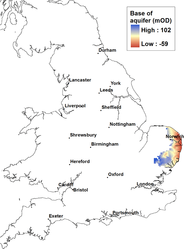
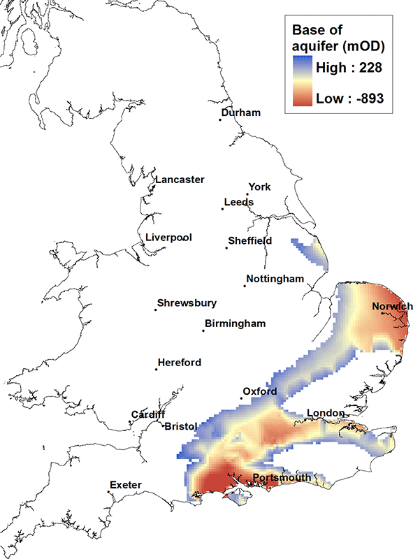
Crag aquifer map. BGS © UKRI.
The Crag is a locally important aquifer, up to about 80 m thick, found in parts of East Anglia. It generally consists of unconsolidated marine sands that may be locally hard and consolidated. The Crag may form a single groundwater-bearing unit where it is connected to overlying glacial sands. The yield is typically moderate to low, of the order of 10 l/sec. Water quality can be poor, iron-rich and hard, particularly below a cover of boulder clay (a Quaternary glacial clay deposit). Seawater intrusion may occur in to the Crag near the coast.
The Crag is present in central, southern and eastern East Anglia. At its western extent, the base is at about 100 m above OD and dips gently to the east, but at its deepest on the coast of East Anglia it is only at about 50 or 60 m below OD.
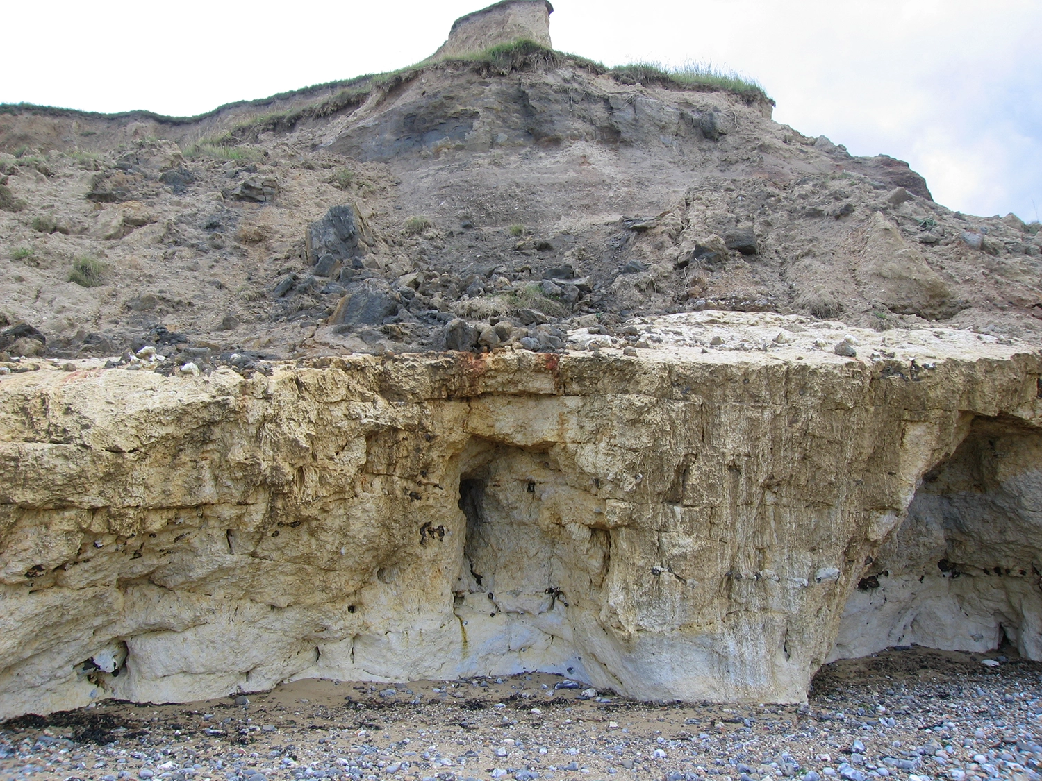
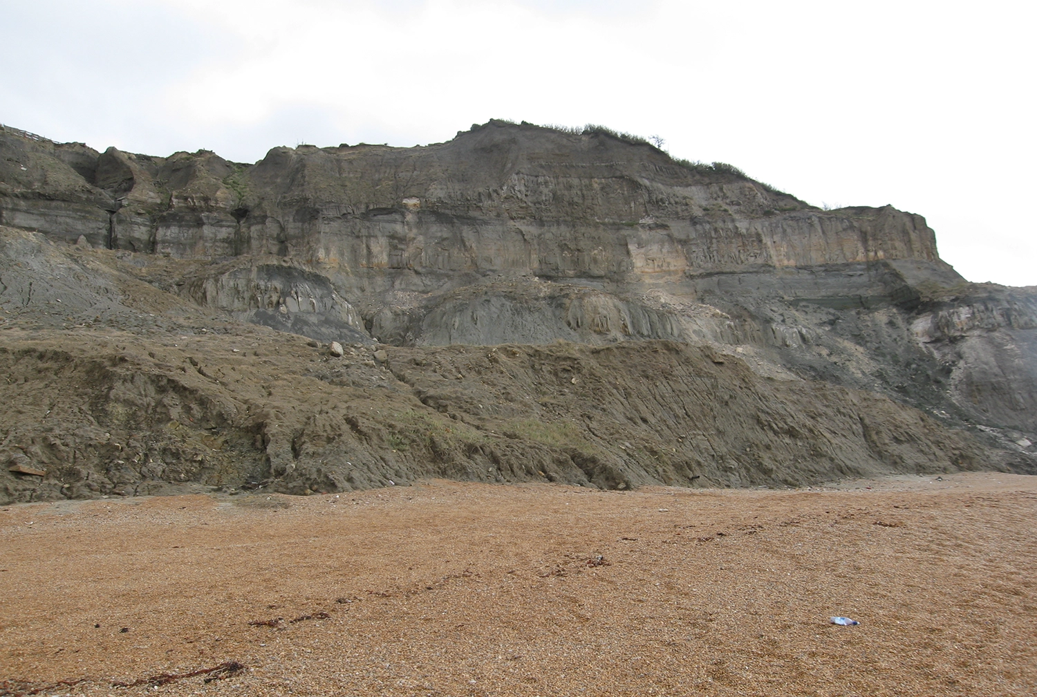
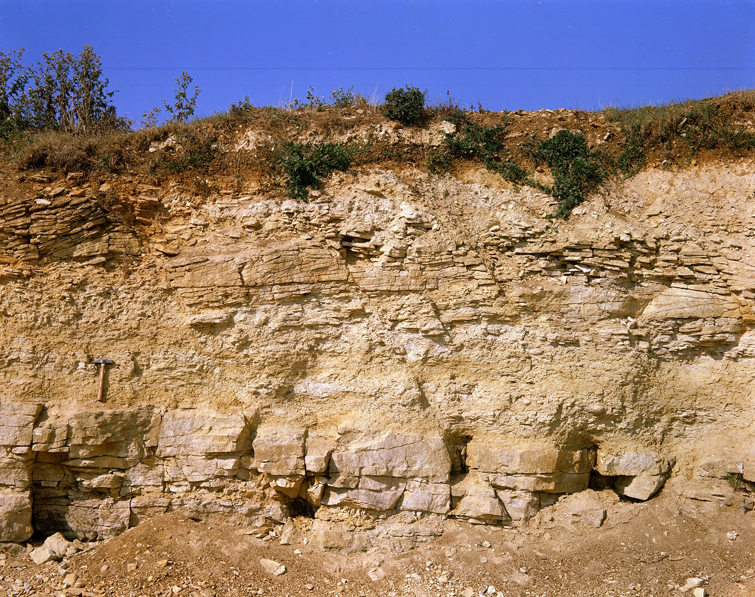
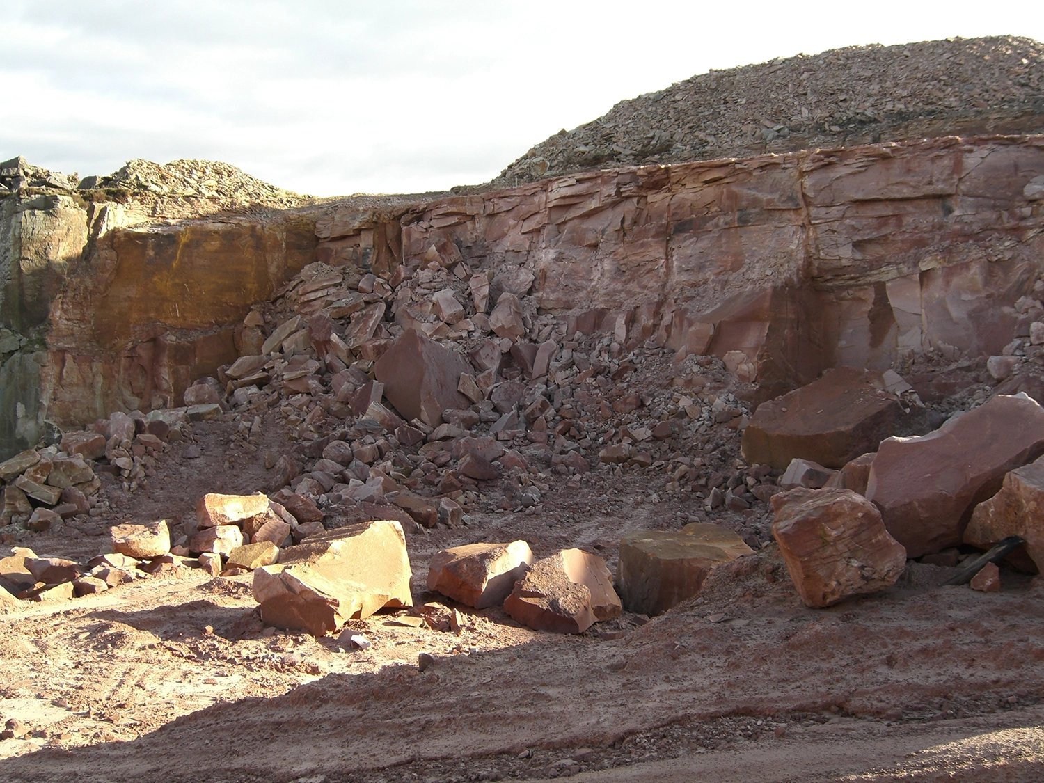
The Wroxham Crag Formation (dark, uppermost layer) of the Crag Group overlying chalk rafts on the east coast of Norfolk, England. BGS © UKRI.
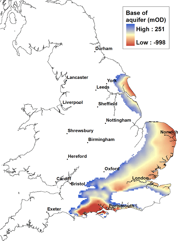
Chalk aquifer map. BGS © UKRI.
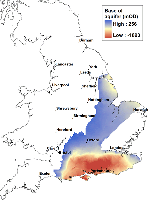
The Chalk is the major aquifer of southern and eastern England. It is a microporous white limestone with low matrix permeability. It is an aquifer due to its well developed interconnected network of fractures. Yields (typically of the order of 150 l/sec) are highest where the density of fractures is greatest and/or where the fractures are enlarged (sub-karst) typically in the top 80 to 100 metres of the aquifer.
Porewater found at depth in the aquifer may be saline, particularly where the Chalk is confined by Palaeogene and Quaternary deposits in the Thames Basin and across East Anglia. The Chalk is prone to diffuse pollution from nitrate and pesticides associated with agricultural activity at the land surface and more locally by point source pollution, for example from leakage or spillage of industrial chemicals and petroleum hydrocarbons.
The Chalk is present in south East Yorkshire, southwards across the Humber and into Lincolnshire. It is also present east and south of The Wash in a swathe across central southern England from north Norfolk, through the Thames Basin and along the Kent coast, down to the south coast, the Isle of Wight and into Dorset towards Portland Bill. It is associated with the iconic scenery of the Chalk downlands and the white cliffs in and around Dover.
The Chalk is exposed at the land surface along its western margins and generally dips east and southward. The base of the Chalk unit to the north of the Humber and along the east coast East Anglia is typically at a depth of the order of 500 m below OD, while in the centre of the Wessex Basin near Southampton the base of the Chalk may be in excess of 700 m below OD.
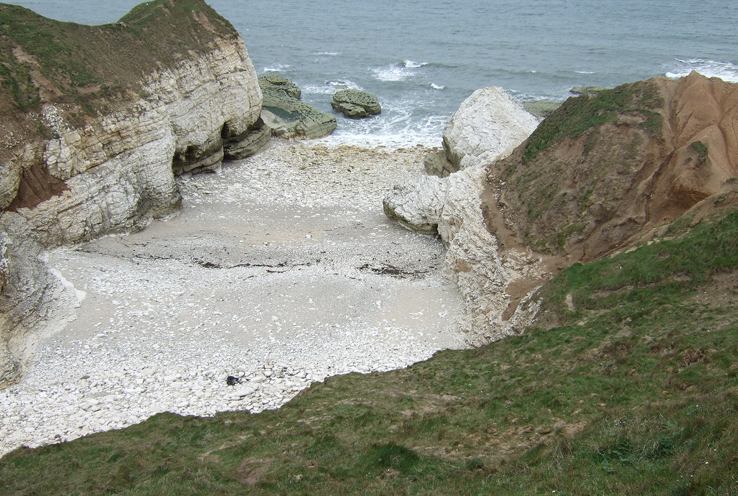
Chalk cliffs, Flamborough Head, England. BGS © UKRI.
Lower Greensand aquifer map. BGS © UKRI.
The Lower Greensand aquifer consists of lithologically variable sands and sandstones that are commonly glauconitic or iron-rich, with local clay-rich or sandy limestone beds. Yields of up to about 50 l/sec have been obtained and the water is typically soft and iron rich, although it becomes harder and more mineralised where it occurs below boulder clay (a Quaternary glacial clay deposit).
The distribution of the Lower Greensand unit closely mirrors that of the Chalk for much of England and Wales. It is not present north of the Humber but is present in Lincolnshire, east of The Wash over large parts of East Anglia, down through Cambridgeshire, throughout the Thames Basin, along the Kent coast and along the south coast of England as far as east Dorset.
The base of the Lower Greensand unit along the east coast East Anglia is typically at a depth of greater than 500 m below OD, while in the centre of the Wessex Basin near Southampton the base may be in excess of 800 m below OD.
The Lower Greensand Group forms cliffs from Blackgang Chine to New Walpen Chine, Isle of Wight. BGS © UKRI.
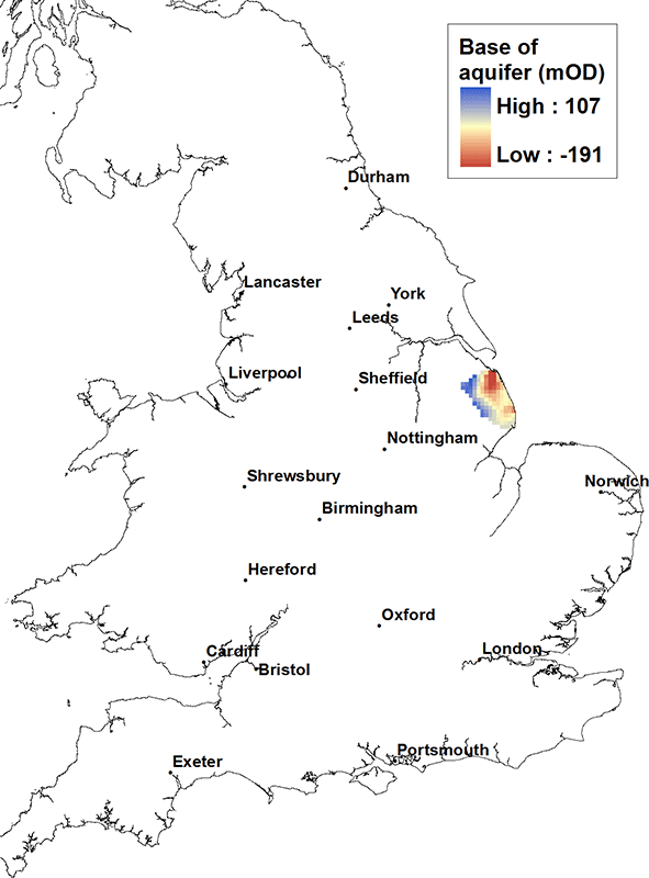
Spilsby Sandstone aquifer map. BGS © UKRI.
The Spilsby Sandstone is present in central and eastern Lincolnshire. It consists of a variably but often poorly cemented quartz sandstone up to about 30 m thick with alternating thin clays and marls. Yields are typically about 80 l/sec. Construction and development of water supply boreholes in the Spilsby Sandstone can be problematic due to the poor cementation of the unit. It can be the source of springs where it crops out at the western edge of its extent.
The Spilsby Sandstone dips gently north-eastward. The base of the unit is typically at about 100 m above OD falling to about 200 m below OD near the mouth of the Humber.

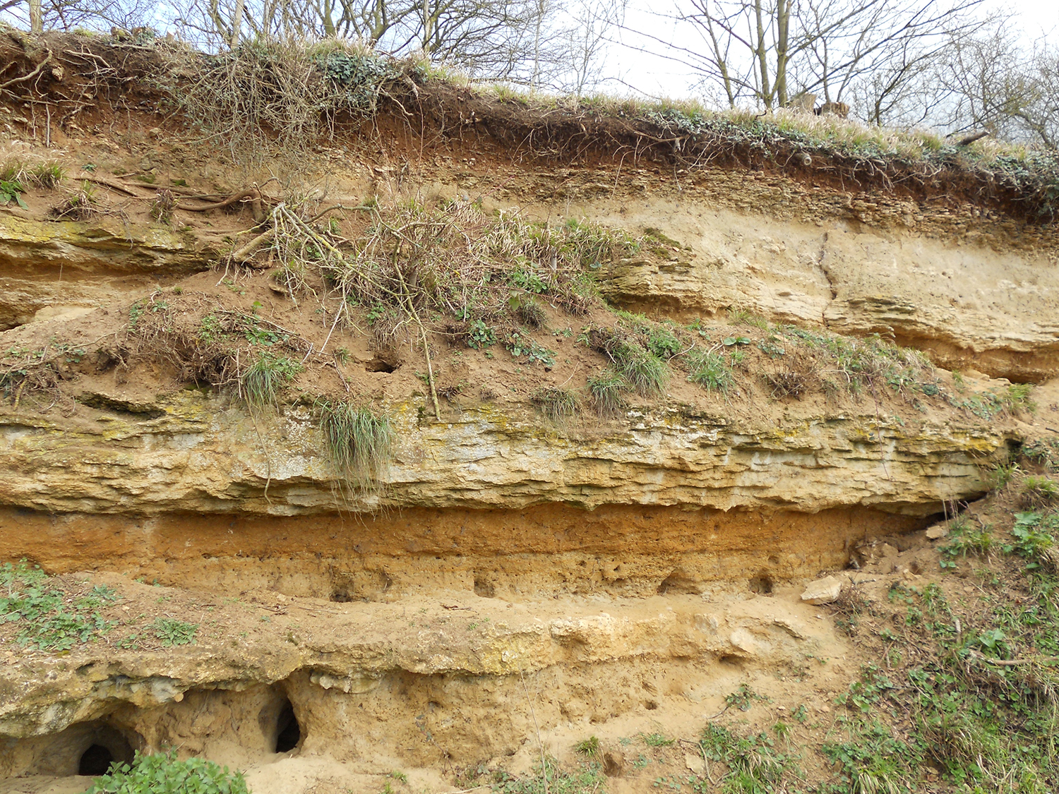
Spilsby Sandstone Formation in Clixby Sand Pit, Lincolnshire. BGS © UKRI.

Corallian limestone aquifer map. BGS © UKRI.
In Yorkshire, the Corallian limestone consists of limestones and grits up to about 110 m thick, thinning to about 20 m towards the south of the region, where the limestones are progressively replaced by clay. It is typically well jointed and gives rise to numerous springs. Here it yields up to 15 l/sec. The base of the unit dips from the west, where it is at about 300 m above OD, to the south-east coast, where it is below OD.
In the Cotswolds, the aquifer is up to 40 m thick, give yields of 5 to 10 l/sec, with water quality becoming increasingly saline down dip as the aquifer becomes confined in the Wessex Basin. The base of the aquifer is highest at its outcrop in the Cotswolds, at about 50 to 100 m above OD, and it dips into the centre of the Wessex Basin to a depth of about 1500 m below OD.
Coralliferous bioclastic limestones of the Corallian Group in Dry Sandford Quarry, Oxforshire, England. BGS © UKRI.
Oolites aquifer map. BGS © UKRI.
The Oolites aquifer unit (comprising the Great Oolite Group and the Inferior Oolite Group) is present in a broad band from Humberside, through central southern England and along the southern coast of England from Kent to Dorset. The aquifer consists of a variable group of limestones, sands and clays up to 150 m thick in Humberside, reducing in thickness to about 50 m in central and southern England. Yields are typically in the range 5 to 15 l/sec. Limestones in the aquifer become increasingly compact within the sequence down dip and the water rapidly becomes saline as the aquifer becomes confined.
The aquifer unit broadly dips from west to south east. It is highest in the Cotswolds at about 250 m above OD. It dips down to about 700 m below OD near the mouth of the Humber and deeply into the centre of the Wessex Basin to a depth of about 1900 m below OD.
Great Oolite Group limestone in a roadside quarry, Northamptonshire, England. BGS © UKRI.
Triassic sandstone aquifer map. BGS © UKRI.
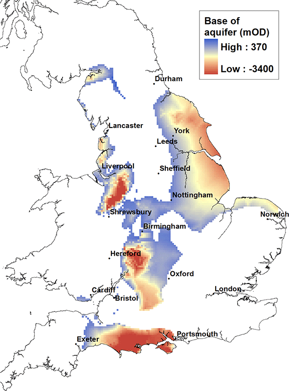
The Triassic sandstone forms the UK’s second most important aquifer after the Chalk and consists of sandstones, conglomerates and marls up to 600 m thick. It can yield up to 125 l/sec of good quality, hard to moderately hard water from the upper parts of the aquifer. In coastal and estuarine areas in the north-west of England, sea water intrusion occurs and groundwater becomes highly saline with depth.
The Triassic sandstone aquifer is present in a series of deep basins throughout the UK including Carlisle, eastern England from Yorkshire to The Wash, the Fylde coast in north-west England, the Cheshire Basin, Shropshire, Worcestershire, and southern England from Hampshire to Dorset. The base of the Triassic sandstone varies from about 100 m above OD at outcrop to deeper than 2500 m below OD in the centre of the Cheshire, Worcester and Wessex basins.
BGS has published a series of reports describing the baseline hydrogeochemistry of the major aquifers of the UK. Geochemistry baseline reports on the Triassic sandstone are available for:
- Liverpool and Rufford
- Manchester and east Cheshire
- Shropshire
- south Staffordshire and north Worcestershire
- west Cheshire and the Wirral

Castle Rock, Nottingham, England, is composed of the Triassic-aged Chester Formation of the Sherwood Sandstone Group. BGS © UKRI.
Magnesian Limestone aquifer map. BGS © UKRI.
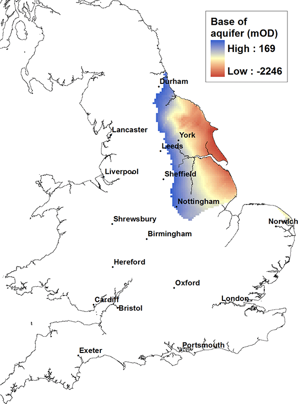
The Magnesian limestone aquifer is present in north-east and eastern England, east of the Pennines from near Durham down to Nottinghamshire and Lincolnshire. It consists of massive dolomitic and reef limestones with marls, sandstones and breccias, and is up to 300 m thick near Durham. Typical yields range up to 50 l/sec from the upper parts of the aquifer, but the water is typically very hard. Sea water intrusion may occur near the coast and groundwater becomes increasingly saline with depth.
The aquifer dips from the west to east. The base of the aquifer is at its shallowest along the western outcrop, at about 150 m above OD, and at its deepest along the eastern coast of England at greater than 2000 m below OD.
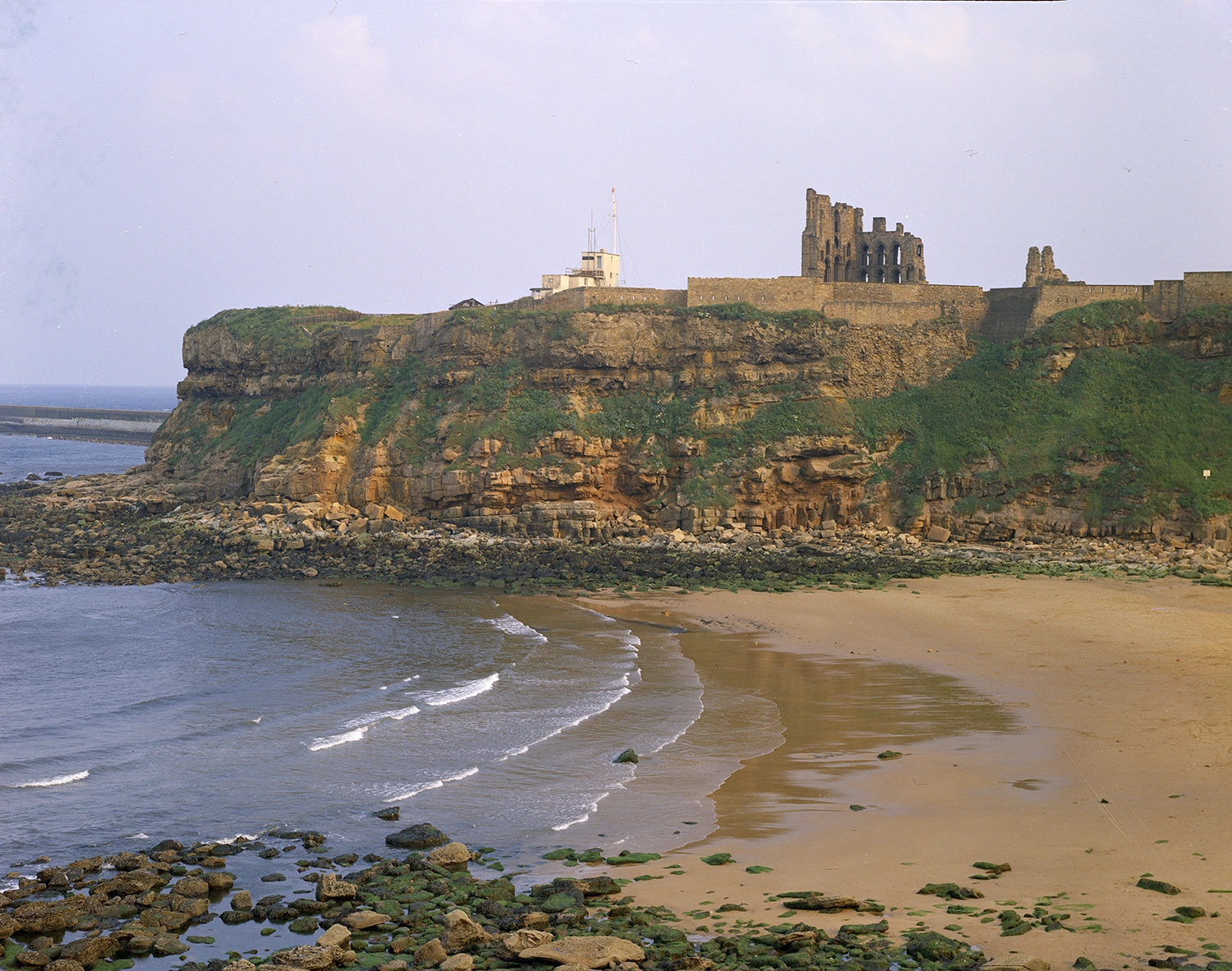
Tynemouth cliffs, composed of (top to bottom) the Roker Formation (formerly the Upper Magnesian Limestone), the Raisby Formation (formerly the Lower Magnesian Limestone), the Yellow Sands Formation and the Pennine Middle Coal Measures Formation. BGS © UKRI.

Permian sandstone aquifer map. BGS © UKRI.
The Permian sandstone aquifer consists of sandstones, marls and breccias. In south-west England, it is up to about 150 m thick with yields up to about 15 l/sec. In north-west England, it may reach up to 300 m in thickness and yields are typically higher at about 25 l/sec from the upper parts of the aquifer. The water in the Permian sandstones becomes highly saline at depth, for example, within the centre of the Cheshire Basin.
This aquifer is present in a series of basins in England and Wales: the southern part of the Carlisle Basin, the Cheshire Basin, in Shropshire and in the south-west of England in Dorset and eastern Devon. The base varies from about 300 m OD at outcrop in the Carlisle Basin to greater than 4000 m OD in the centre of the Cheshire Basin.
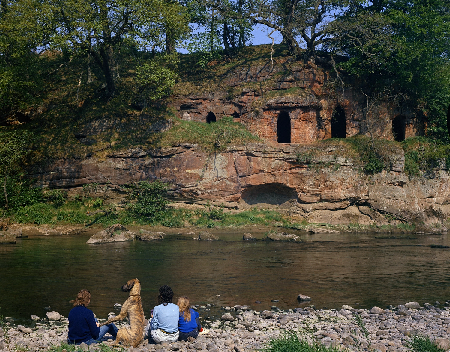
Dune-bedded, silicified Penrith Sandstone Formation exposed in the eastern bank of the River Eden in Cumbria, England, with artificial caves. BGS © UKRI.

Carboniferous limestone aquifer map. BGS © UKRI.
The Carboniferous limestone is a massive, well-fissured, karstic limestone that gives large water supplies of up to 175 l/sec from resurgences in the Mendips and South Wales and borehole yields of up to 40 l/sec from the upper parts of the aquifer.
BGS has published a series of reports describing the baseline hydrogeochemistry of the major aquifers of the UK. A baseline report on the Carboniferous limestone of northern England is available.
The Carboniferous limestone aquifer is present in a number of areas in England and Wales, sometimes at great depth. It is found across large parts of northern England, eastwards from the Peak District to the Lincolnshire coast, in north-east Wales, extensively in South Wales and across the Bristol Channel into the Mendips, Bristol and Bath area and at depth through parts of southern England, including east Kent.
At outcrop, the base of the aquifer can be found at between 330 to 500 m above OD, for example in the Peak District and in South Wales. However, in the centre of the northern England, North Wales and East Midlands basins, the aquifer formation can be found at depths well in excess of 3000 m below OD.
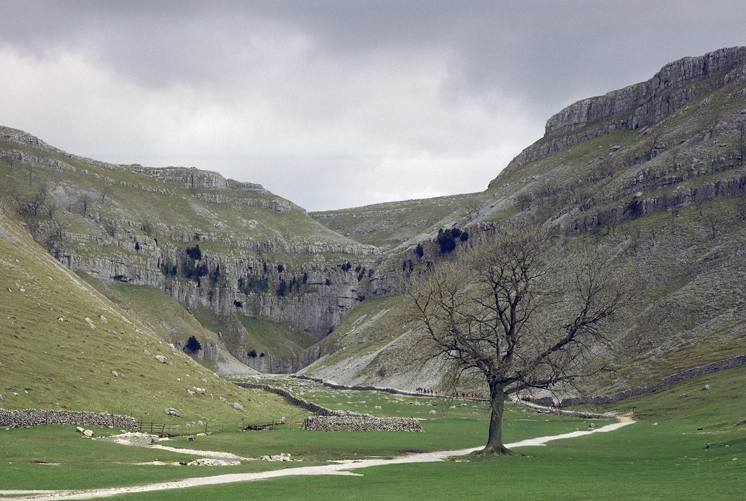
Gordale Scar, North Yorkshire, England. Gordale Beck cut the gorge through the Carboniferous limestone of the Malham Formation. BGS © UKRI.
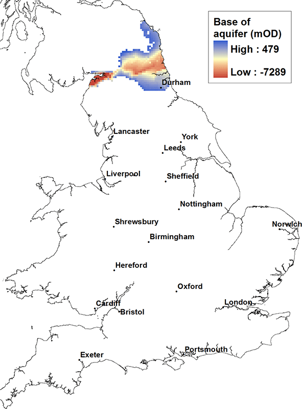
Fell Sandstone and Border Group aquifer map. BGS © UKRI.
The Fell Sandstone and Border Group aquifer consists of friable, quartz-rich sandstones with minor pebbly and silty bands. It is up to about 300 m thick. Yields are quite variable due to variations in the degree of jointing but typically less than 10 l/sec from the upper parts of the aquifer. Water is soft at outcrop but becomes harder down dip, particularly below cover.
The aquifer is found from the coast west of Carlisle, across northern England, to the coast between Sunderland and Berwick-upon-Tweed. At outcrop, the base of the aquifer can be as high as 450 m above OD, but at depth in the Carlisle Basin it can be found in excess of 7000 m below OD.
Fell Sandstone Formation in Doddington Quarry, Northumberland, England. BGS © UKRI.
OD refers to ordnance datum. It is the common reference level to which all vertical elevations (heights) on maps are related. As a simplification, it can be considered as equivalent to sea level.
On the maps published by BGS, a height given as a positive number is above OD and a negative one is below OD.